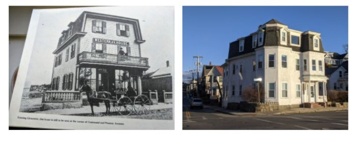
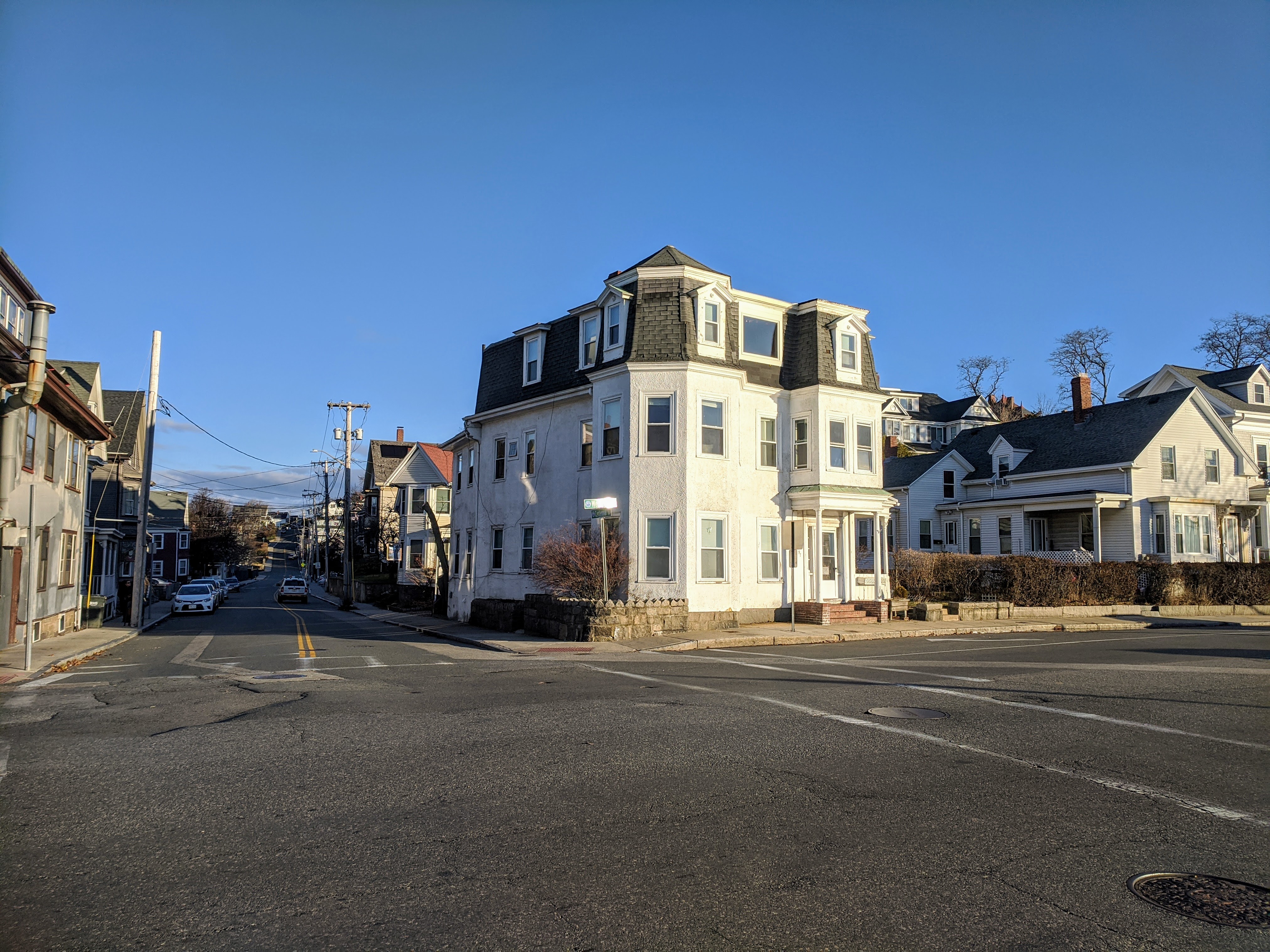
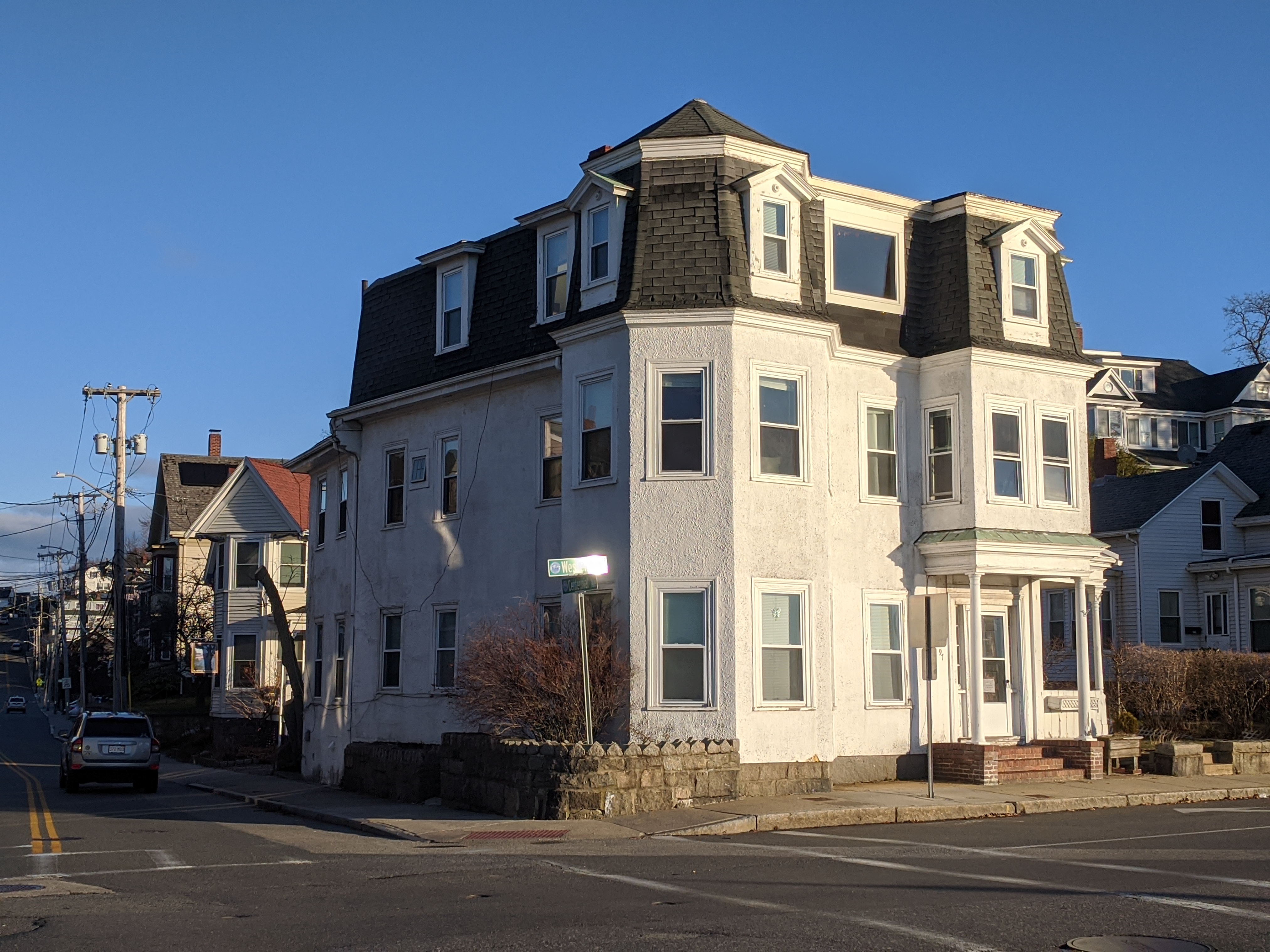
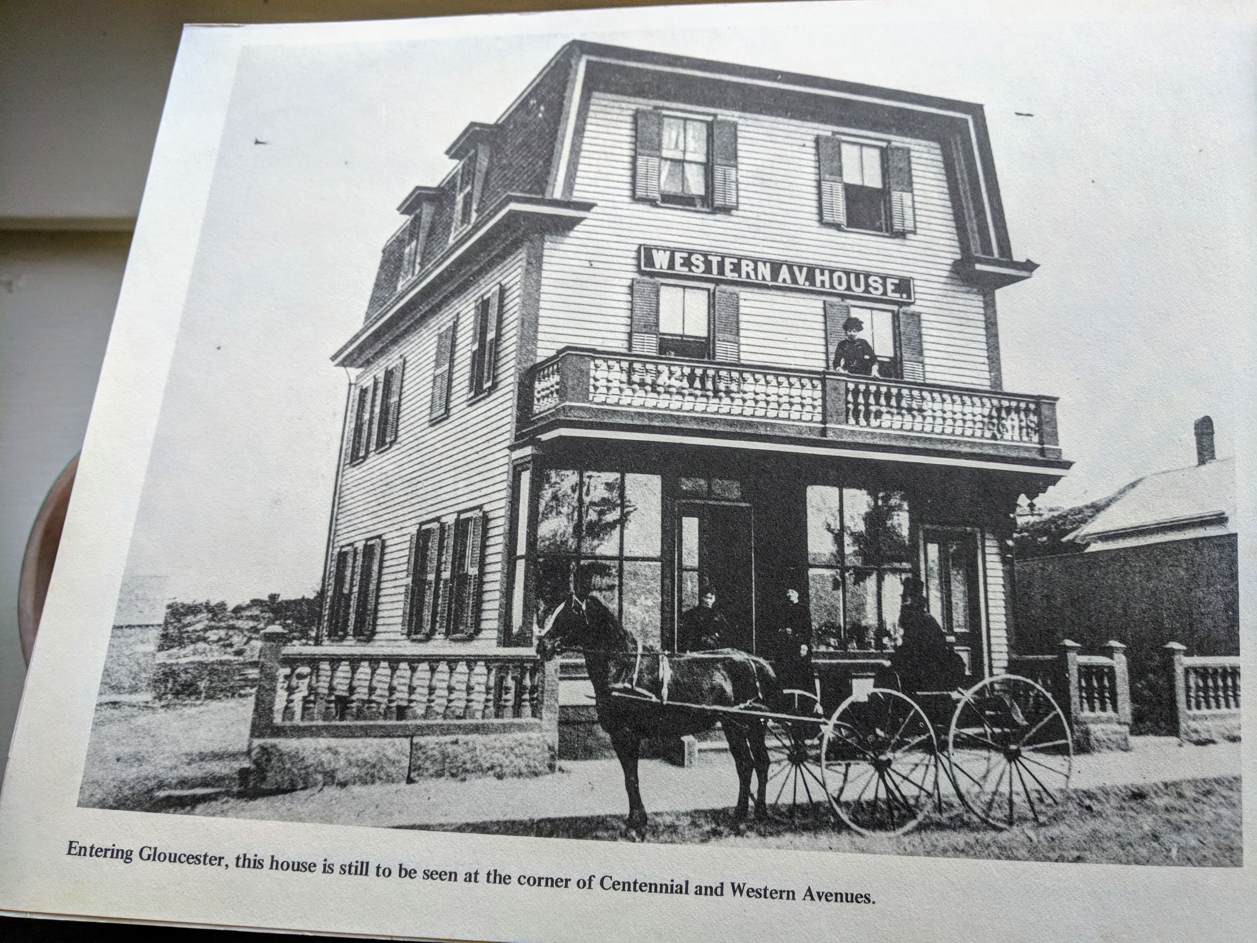
Bet you can name the cross streets. Scroll down for Then | Now Answer
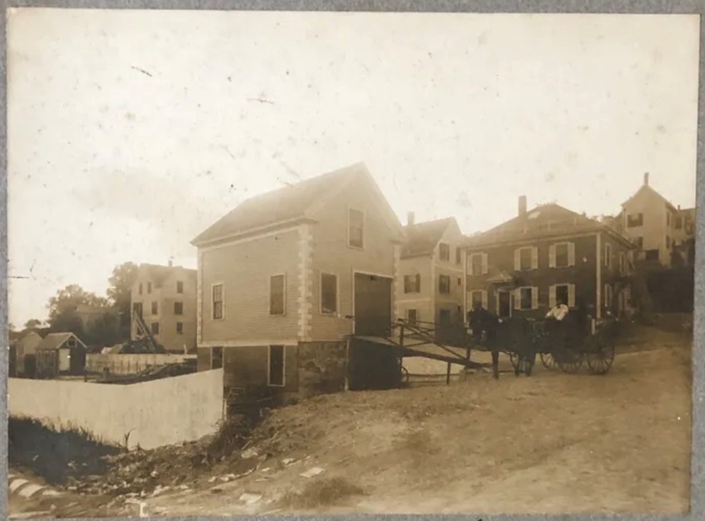
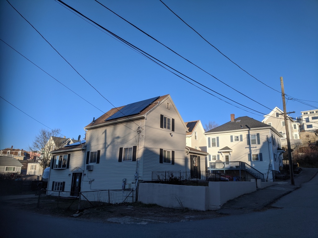
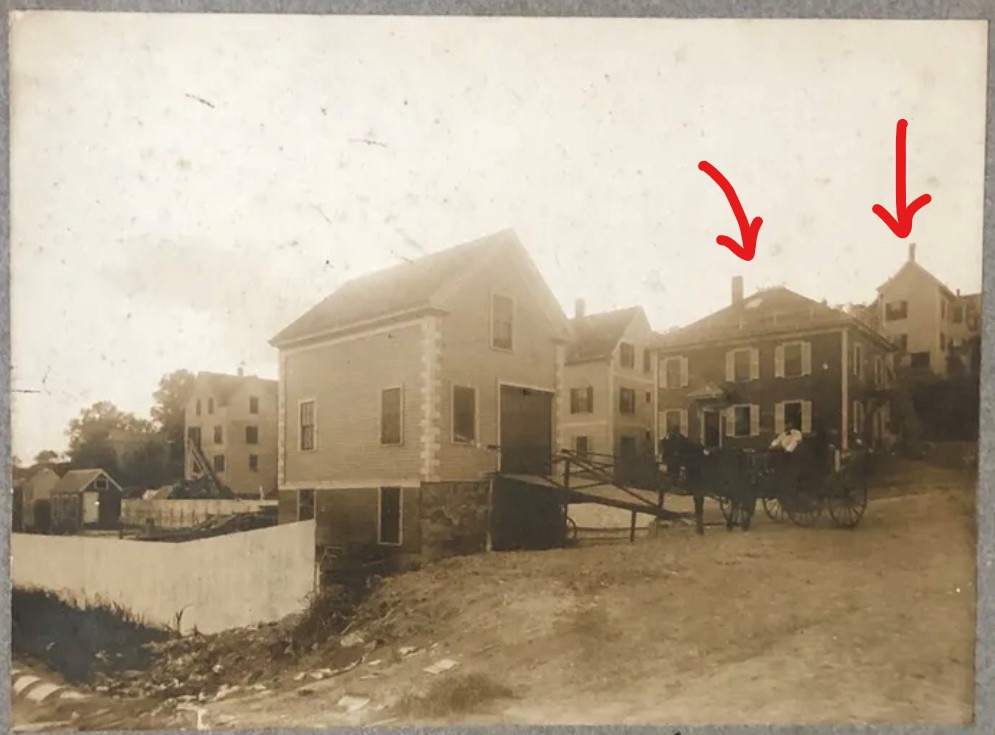
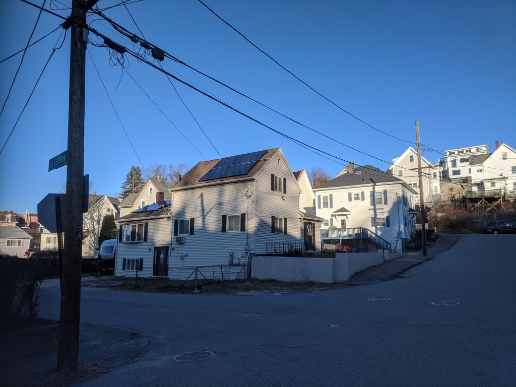
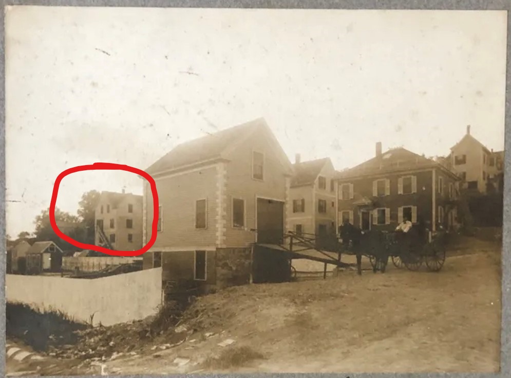
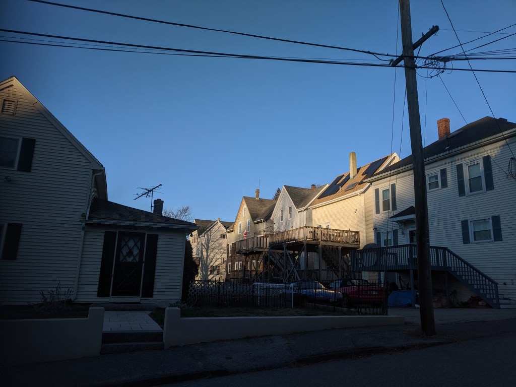
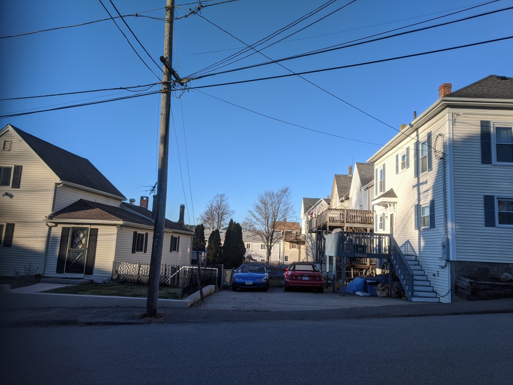
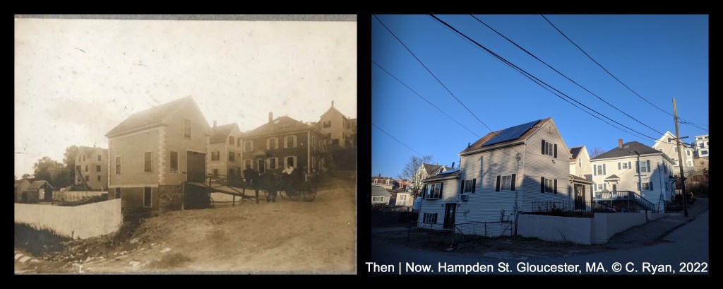
vintage photo album snapshot, with stable ramp: courtesy Jill. contemporary photos: C. Ryan, December 20, 2022
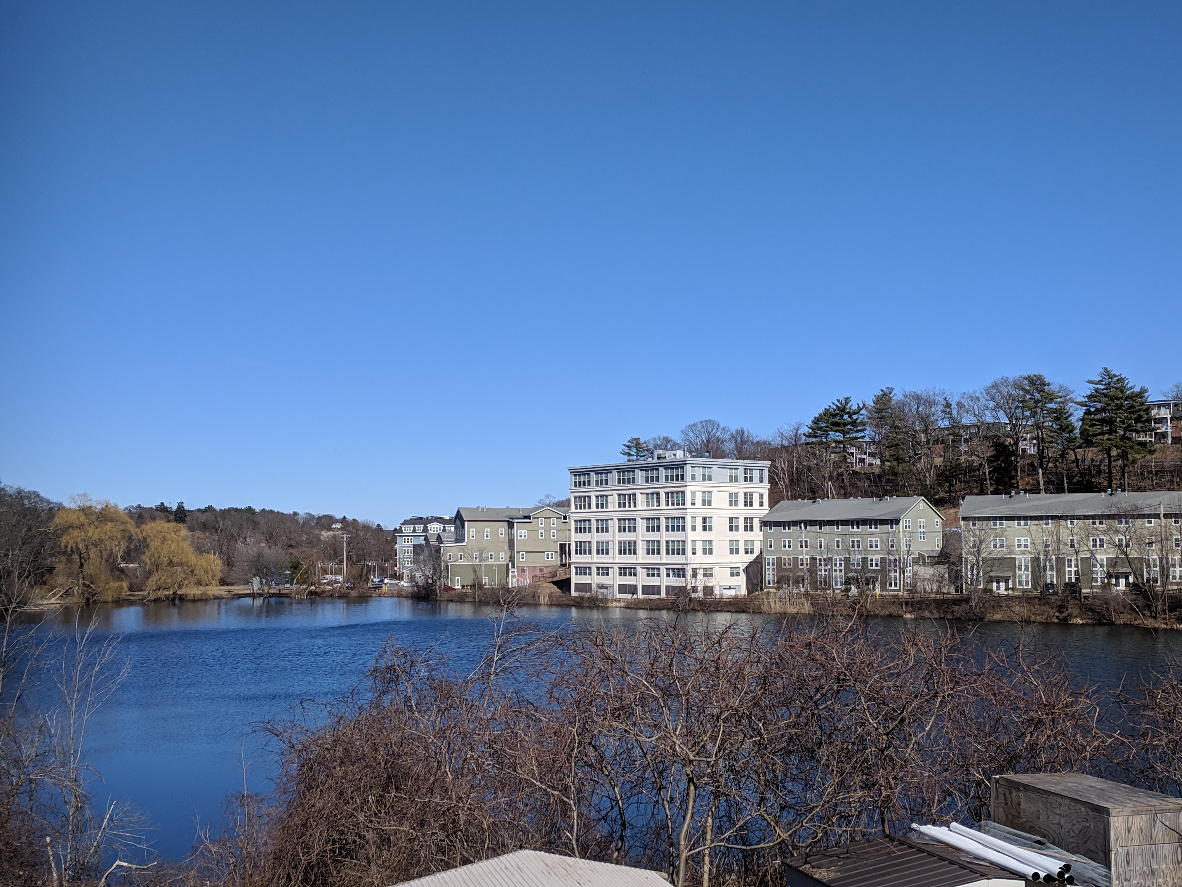
My View of Life on the Dock

Bet you can name the cross streets. Scroll down for Then | Now Answer
vintage photo album snapshot, with stable ramp: courtesy Jill. contemporary photos: C. Ryan, December 20, 2022

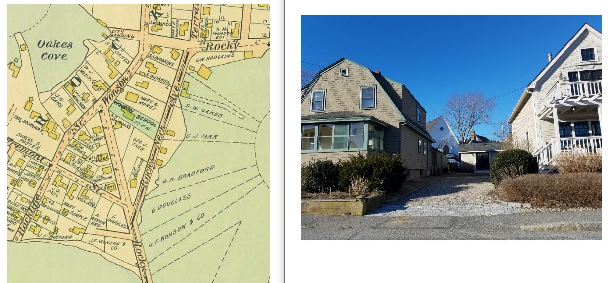
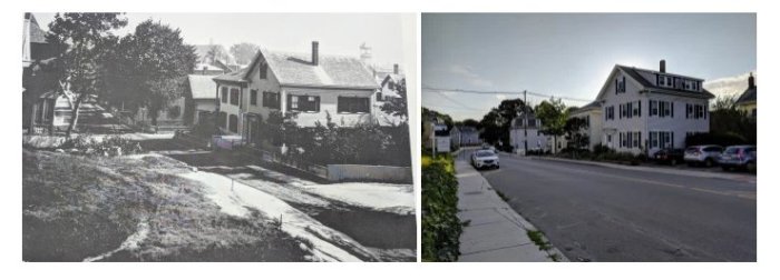
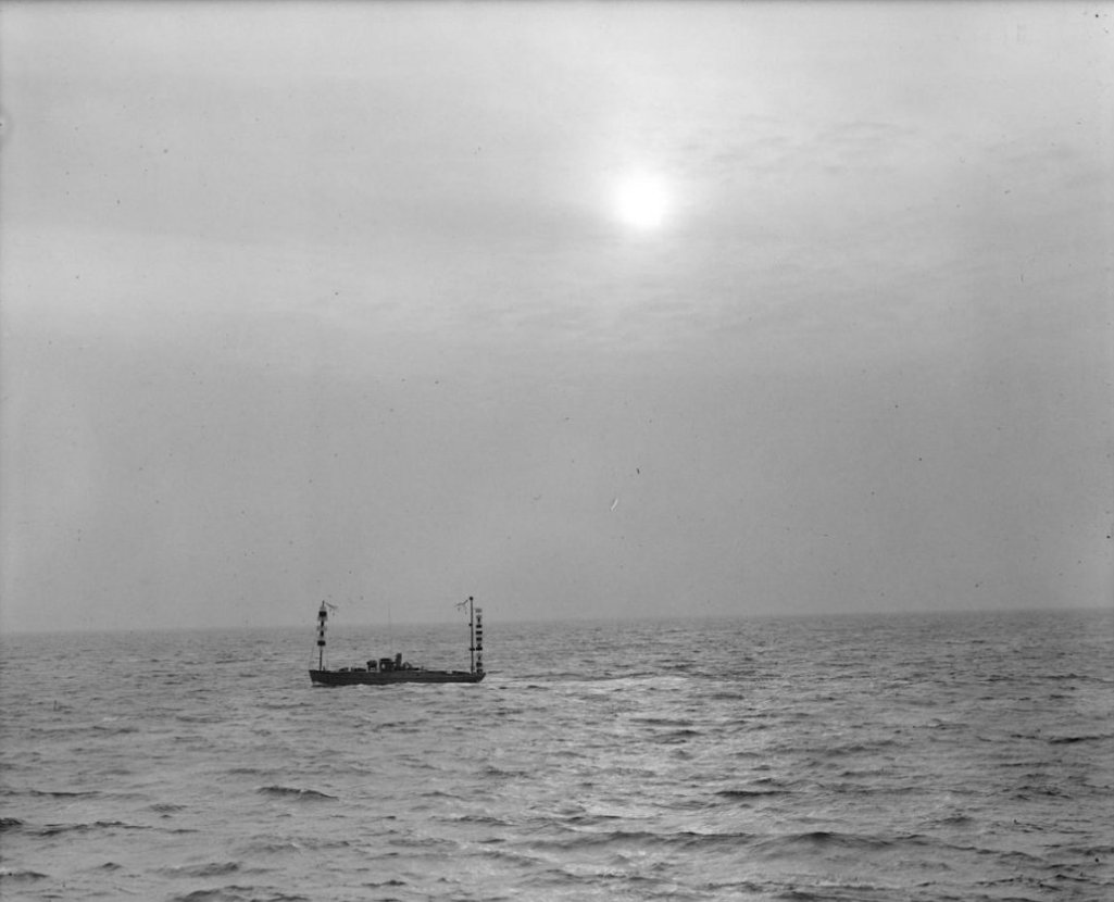
October 30, 1926 – 96 years ago today


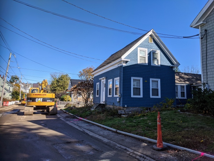
photo description: 92 Mt. Pleasant THEN detail from Sanborn Fire Insurance map, 1917; 92 Mt. Pleasant NOW (same footprint)
“Gloucester, Oct. 30
Hale and hearty at the age of 90, Capt. William W. Foster, an ancient mariner of East Gloucester, strolls down to the wharves every day, puffs his pipe and looks with optimistic eye on life in general, and the passing fishing schooners remind him of his early experiences.
Capt. Foster was born in Port Medway, N.S., Oct. 20, 1836*. He lives with his daughter, Mrs. Susan B. Eason, wife of patrolman W. Wallace Eason of the Police Department, at 92 Mt. Pleasant av, East Gloucester. There, Oct. 20, he quietly observed his 90th birthday.
Capt. Foster’s life has been mainly passed on the seas. Until he was 15 he worked on his father’s farm. Then he went fishing for the Summer. The next year he shipped on a salt fishing trip to the Labrador and for many years thereafter followed the sea, fishing, and on merchant voyages to the West Indies.
He was married in 1872 to Miss Patience Cole of Liverpool, N.S., after which he worked as a stevedore at that place. In 1877 he shipped on a voyage to the Grand Banks.
The vessel came to Gloucester to dispose of her cargo.
Mr. Foster liked the old fishing town so much that he determined to make it his home and so shipped out of here on fishing voyages and worked around the wharves. in 1882 he sent for his wife and family.
In January, 1903, his wife died and his daughter, Dezlah, assumed the duties of mistress of the home until 1911, when he received word from his mother that his father had died. Then he went home to live with his mother until 1916 when his mother died. In 1923, his son, Harry W. Foster of the police department went down to Port Medway and brought him back to Gloucester.
Captain Foster is in good health. he reads the papers and magazines with the aid of glasses. Except once when he was taken with the cramps, he never has had the services of a physician. While he enjoys a good smoke he has always been an abstainer from liquor.
His grandfather, Joseph Foster, died at 93.
His father, Benjamin, lived until 92.
His mother saw the ripe old age of 103.
He has two sons, Harry and J. Mack, and two daughters, five grandchildren and seven great grandchildren.”
Boston Globe, 1926
Capt. Foster returned in Gloucester’s tercentenary year, and stayed until his death in 1928. His daughter, Susan, died Oct. 31, 1966. Her husband was officer W. Wallace Eason. Capt. Foster’s son J. Mack died Dec. 10, 1931 (widow Flora G., resided on Highland). In the 1930s, his son Harry W. was employed as a salesman. I wonder what happened to Dezlah.

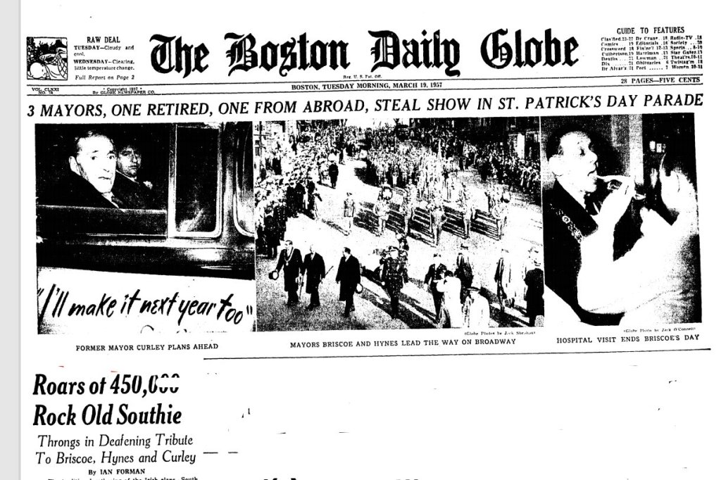
Since the parade in Boston is cancelled this year, here are a few Boston Globe St. Patrick’s Day stories from the past that mention Gloucester.

St. Patrick’s Day Parade: “Roars of 450,000 Rock Old Southie – Throngs in Deafening Tribute“
Among the marching groups, a message from Gloucester:
“…Typical of the pure fun of this Irish carnival was the green-clad junkie’s horse and wagon, topped with a dozen members of the Hibernian Student Assn. There was also the usual assorted nags, jockeyed by small boys in green derbies, and a number of other informal entries, like the man with the green-lettered sign, “Eat Gloucester Fish.”
Forman, Ian. “Roars of 450,000 Rock Old Southie,” Boston Globe. 1957 March 19. Front page, continued p.22
South Boston St. Patrick’s Day Parade in 1968 featured Gloucester youth, St. Peter’s Bagpipe Band, as the bring it home musical act, – were you watching or marching?
“The last musical unit to bring up the parade was St. Peter’s Bagpipe Band of Gloucester. As the boy and girl pipers marched through the rain past the final reviewing stand, they lifted their water-soaked bagpipes to their lips and proudly skirled out “The Wearing of the Green.”
Davis, William. “‘Twas a ‘Soft Day’ for Boston’s Irish.” Boston Globe, 1968 March 8, p.19.
Local politics
“the political longshot from Gloucester…He credited Al Smith for his courage in the face of bigotry, starting a job that Jack finished last November.”
“About Time We Knew: Ben Smith is Irish,” Boston Globe. 1961 March 20
Nurses from counties Cork, Limerick and Donegal, invited guests, were “beautiful, young and single.” Because 1961.
A children’s medley performance at St. Ann’s made the St. Patrick’s Day roundup news. Do you recognize family surnames? (The Church is spelled St. Anne’s in this Boston Globe article.)
“The day of Ireland’s patron saint was fittingly observed here today, the Sunday school teachers of St. Anne’s Church giving an excellent entertainment, consisting of the operetta, “A Trip to Europe,” and readings, tableaux. The entertainment was under the management of Rev. C. W. Regan, assistant at St. Anne’s. The hall was packed with enthusiastic friends of the performers, who generously applauded the finished manner in which the various parts were rendered. The tambourine drill in the second part was a picturesque and pleasant feature…The readings by Miss Maggie Keefe and the tableaux also won high favor from the audience…”
Boston Globe 1892
Names mentioned: Jeannie Dooling, Eddie Fanning, Maggie Fanning, Michael Fanning, Etta Gibbs, Maggie Gibbs, Miss Etta Greenleaf, Hannah Harris, Lizzie Healey, Charles Hennessey, Maggie Keefe, Master George Kelley, Denis Moore, Miss Mary Murphy, Miss Sadie McAuley, Hugh McDonald, John O’Brien, Willie O’Brien, Nellie Nugent, Katie A. Roach, Miss M.E.J. Roche, Clara Smith, Katie Smith, Master Walter Smith, Miss Maggie Wells, Dora West, Clara White. Minstrelsy costumes were part of the program, boys were assigned roles dressed up as “four little curly headed (slur). ” 1892
“The annual St. Patrick’s Day entertainment of St. Ann’s Catholic parish was held last evening in City Hall auditorium. The hall was filled. overture was by Ralph Handran, pianist Helen Handran, violinist, and Helen Mitchell, drummer. Vocal solos by Mrs. George Adams, Mrs. James Cunningham and Joseph Buckley; violin solo Miss Lucille Rowe; reading, with music, Miss Irene H. Veno; address, “Christian, Citizenship,” Charles S. O’Connor of Boston; selection by the orchestra. There was community singing.”
My friend dropped off her scrumptious Irish soda bread so it feels like a pot of gold already.
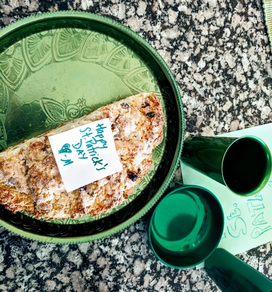
What’s your pot of gold at the end of the rainbow this year?

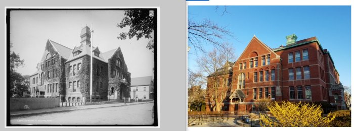
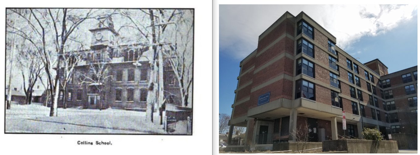
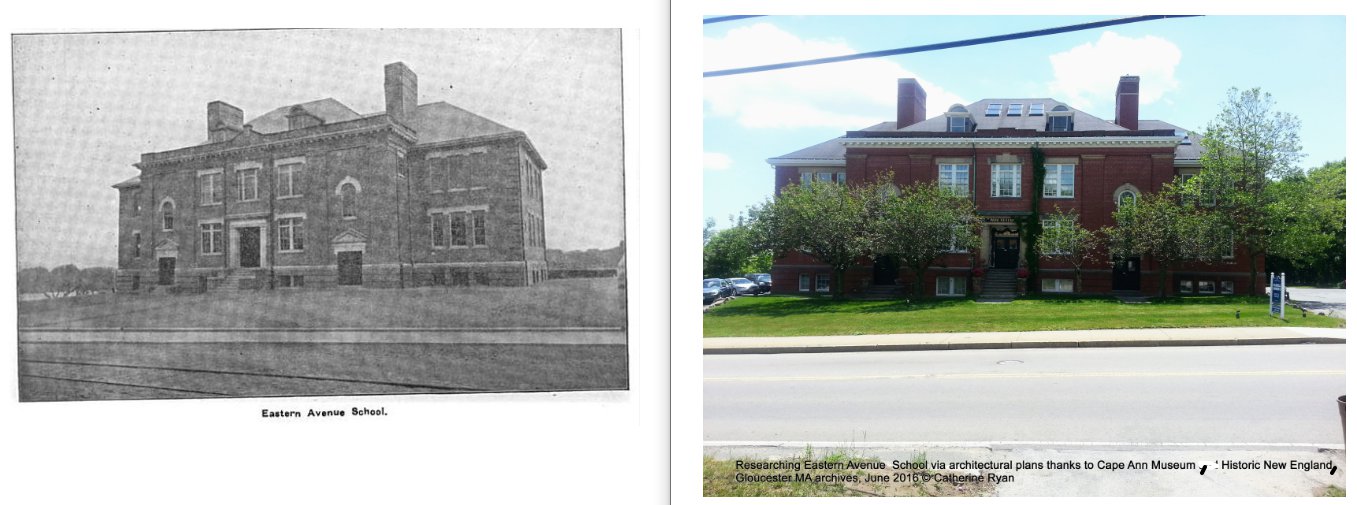
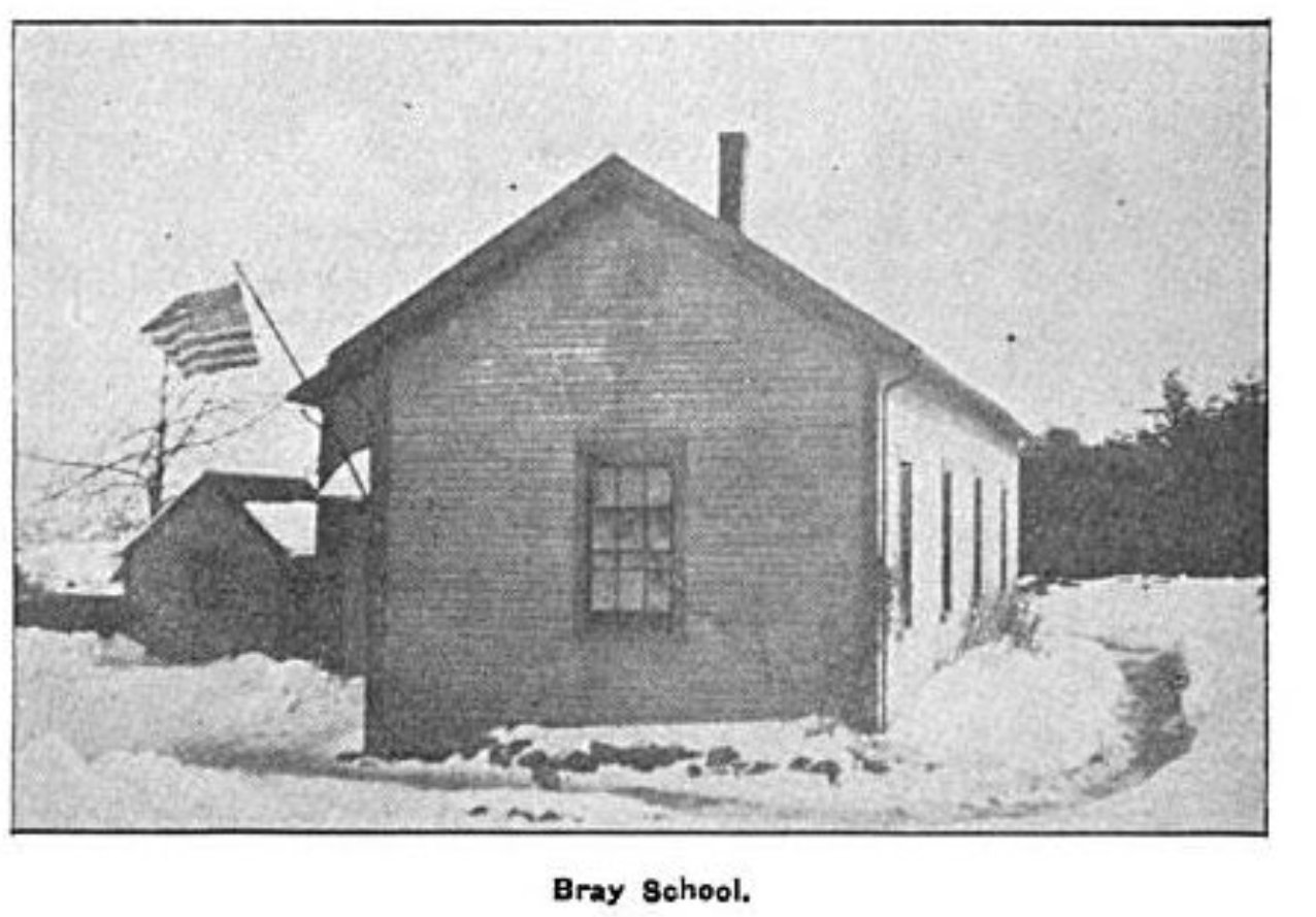
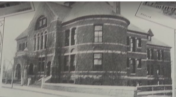
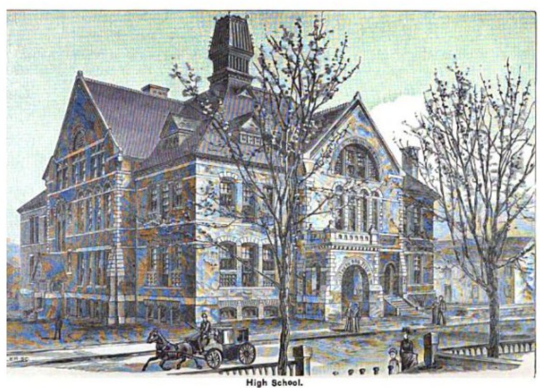
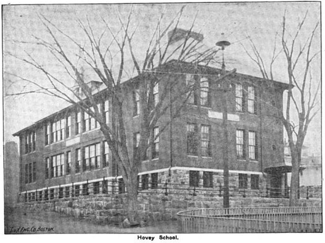
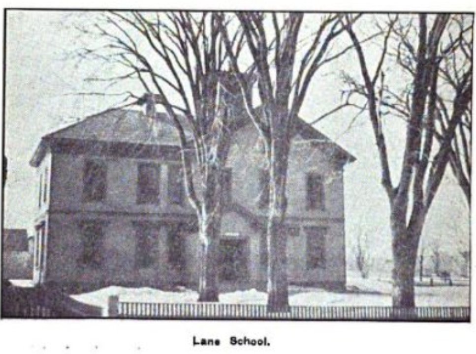
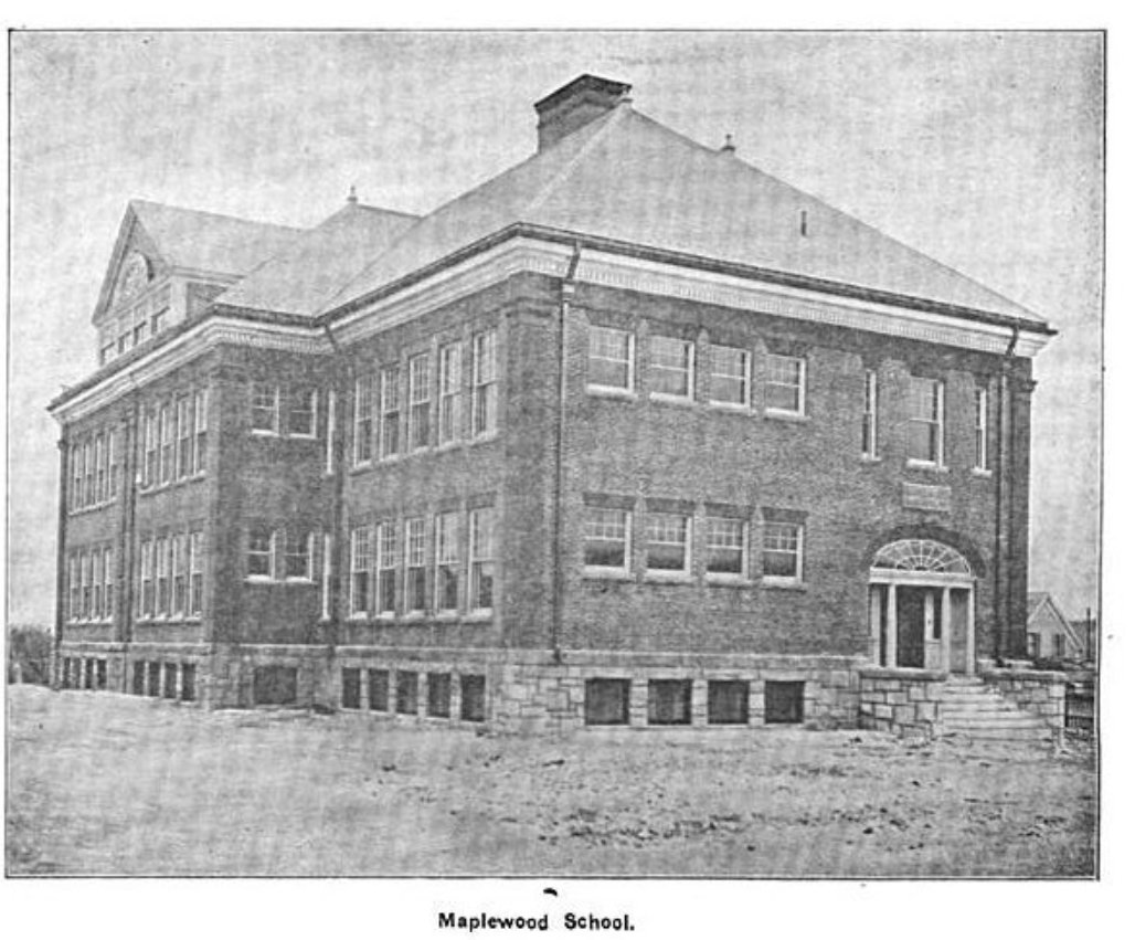
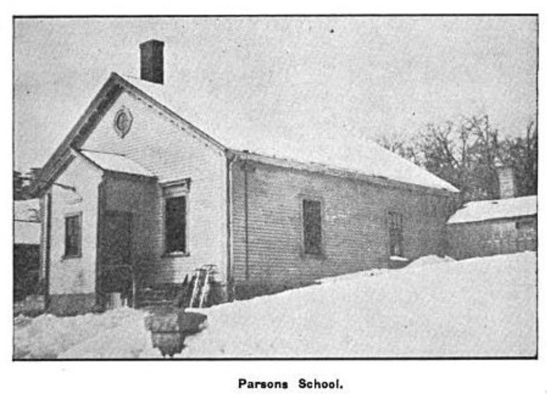
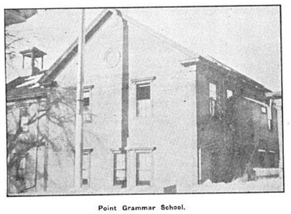
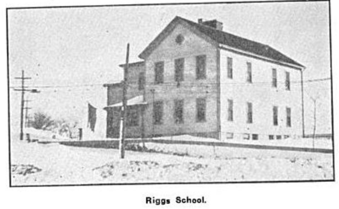
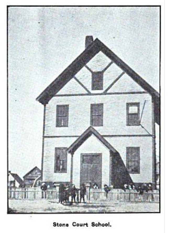
Explore a selection of Gloucester school house properties built circa 1800s-1920s. There is a greater quantity of structures still standing than not.
Note: Pinch and zoom and/or click to enlarge photographs, depending upon your device. There are three galleries of images (side by side comparisons; all vintage; and all contemporary), a self-guided map for a driving tour, excerpts from James Pringle 1892 Gloucester history, and newspaper coverage of then “new” schools. Don’t miss the Boston Globe feature about the Eastern Avenue school published in 1905. There’s another wonderful piece about a very special elementary school class –which enrolled more girls than boys–offered at Sawyer school on Friend Street.


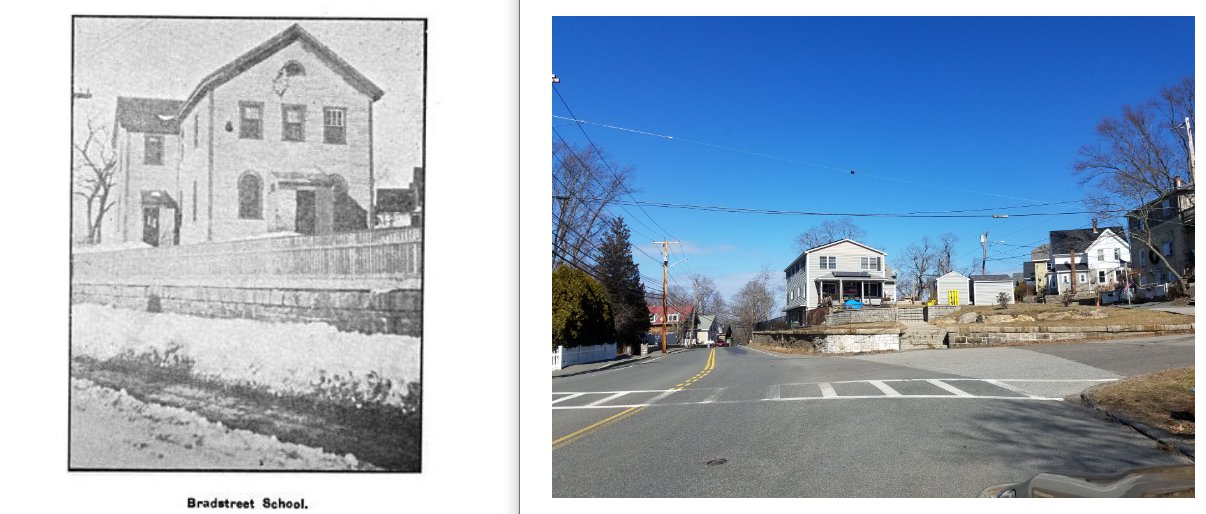


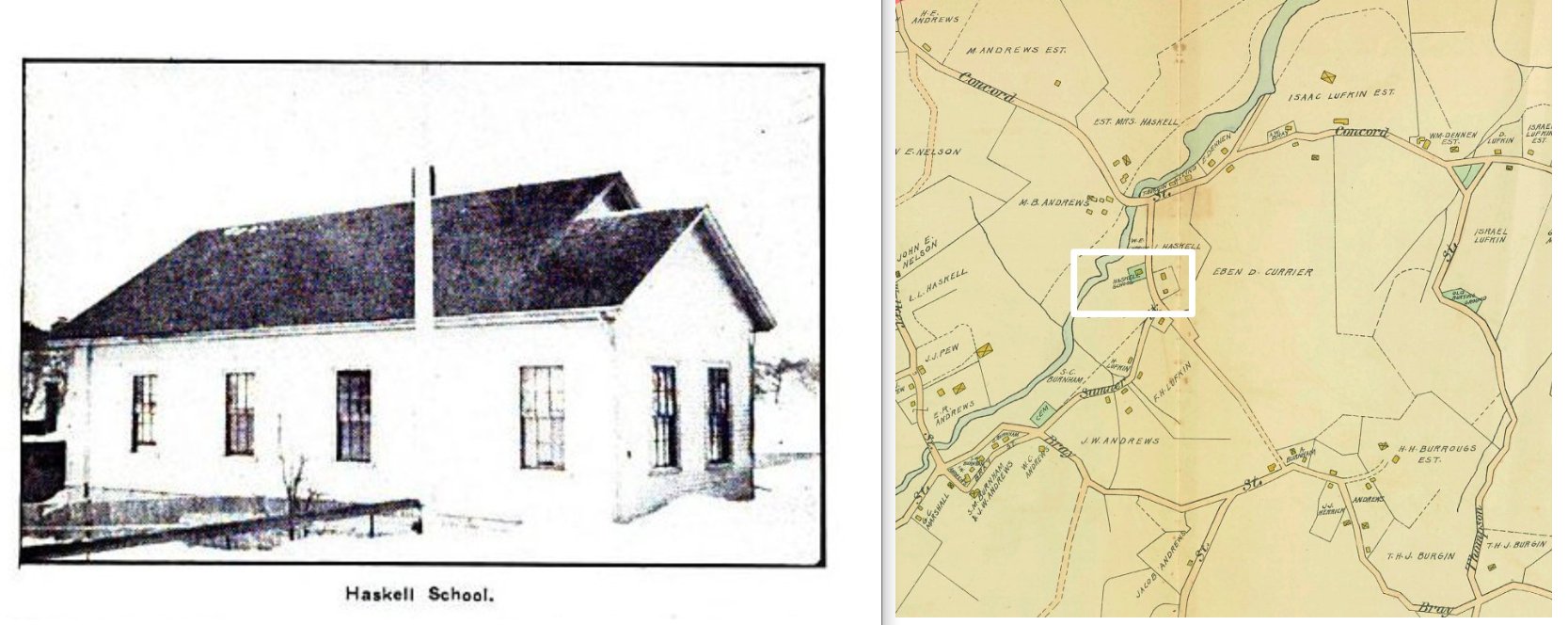


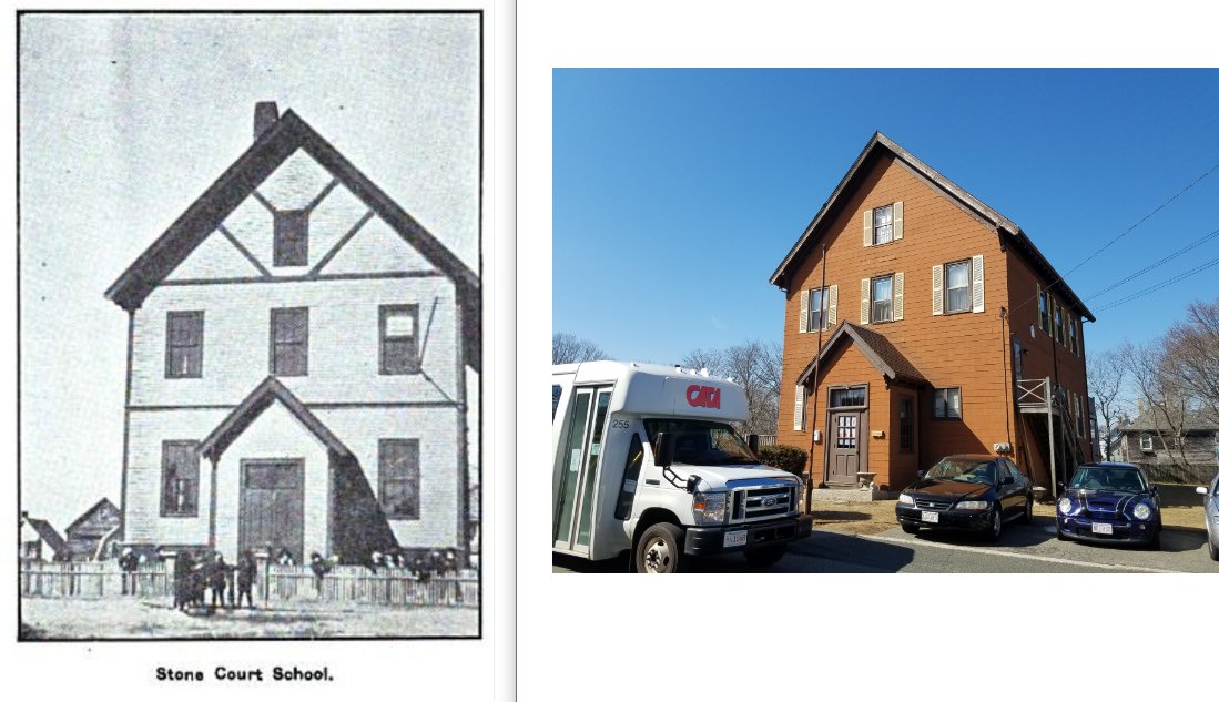
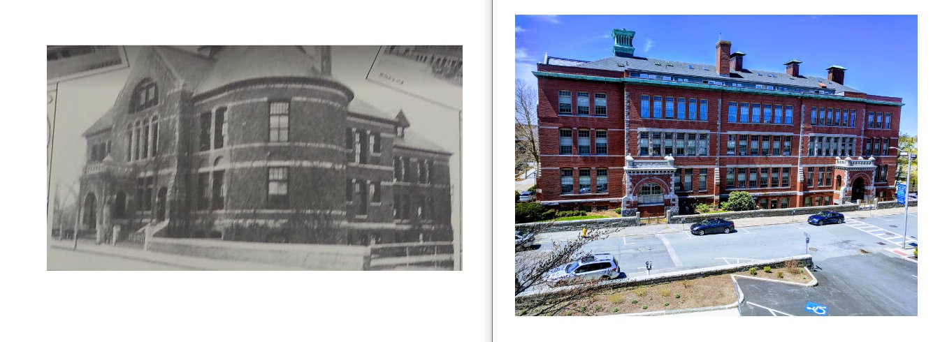

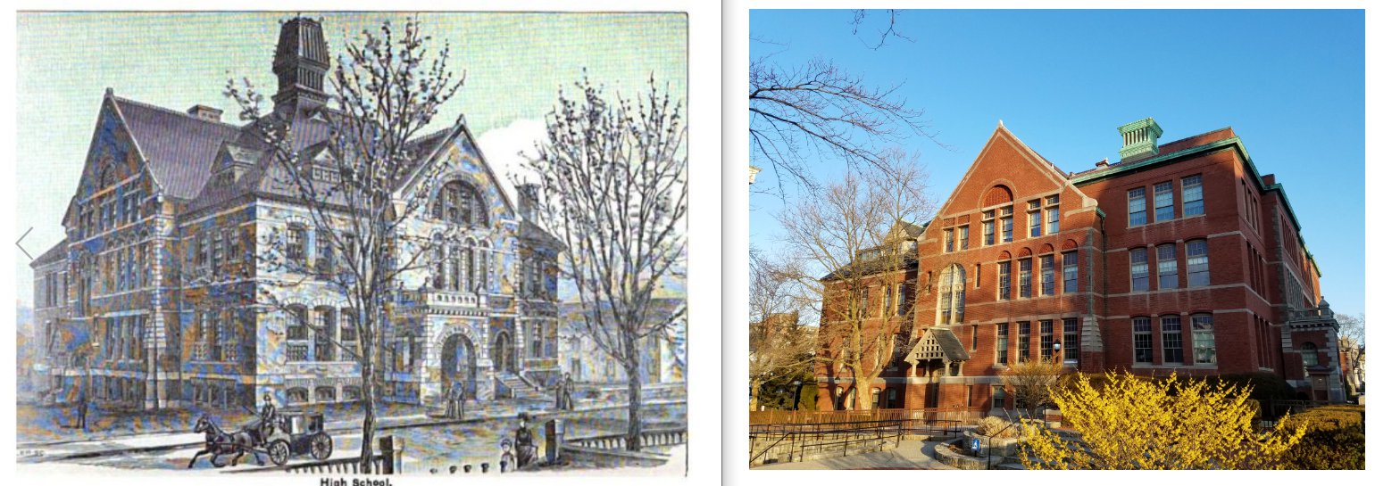


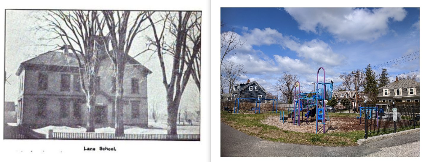
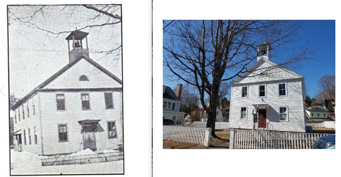
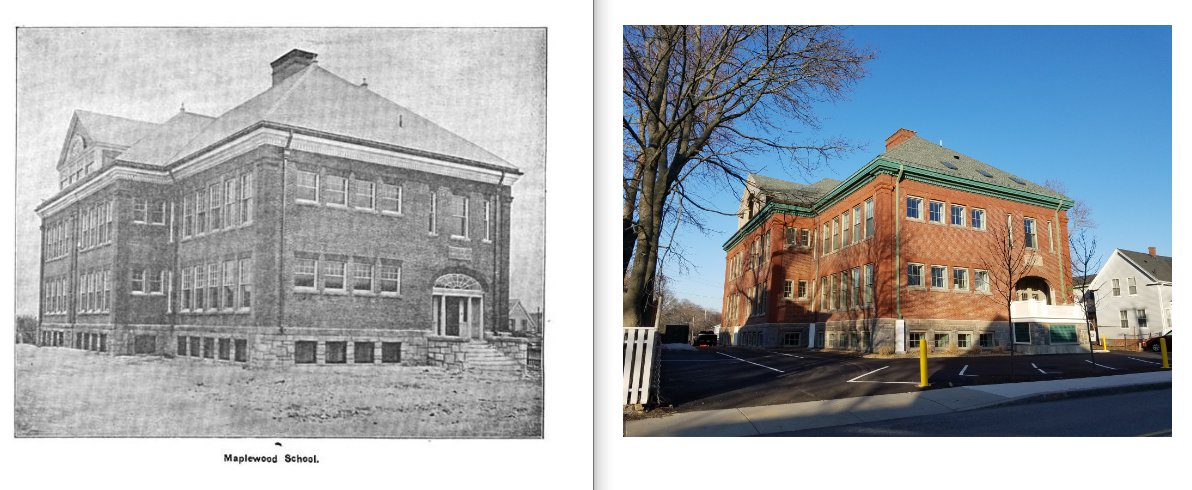


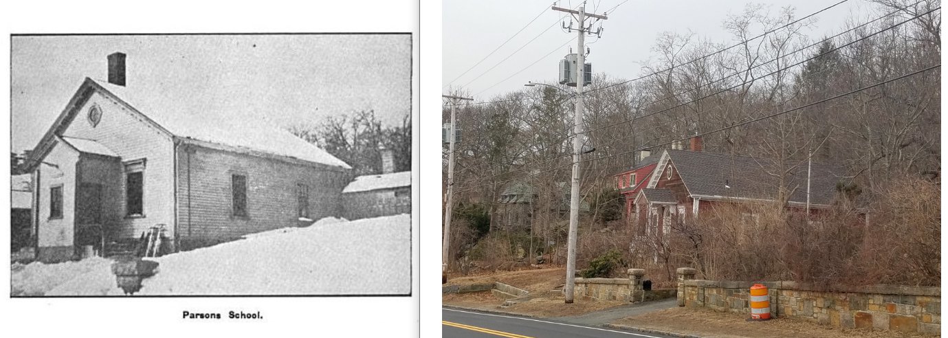


Bold indicates extant structure; italicized indicates structure no longer there; GLO = MACRIS id state’s archives- “The Massachusetts Cultural Resource Information System (MACRIS) allows you to search the Massachusetts Historical Commission database.”


")
")


")
")
")

")
")


")


")
")

")


")


")
")
")
")

")

")
")
“The High school-house on Dale Avenue was erected in 1888 and ’89, the total cost, including land, being $100,000. This building, one of the most imposing and commodious of its kind in New England, is built of brick with granite trimmings.” and “The first High school-house was erected in 1851 on the southwestern corner of the present lot at a cost of $3,100 including the land. It was enlarged in 1870 and 1878, and was destroyed by fire May 11, 1887.”
“The Hildreth school-house on Eastern Avenue was erected in 1884, at an outlay of $18,000 for building and furnishing and $4,000 additional for grading.”
“Lord Bros, were awarded the contract to build the Babson school-house on Park Street for $17,498. This edifice was erected on site of an old burial ground.” and “The first brick structure, the Babson school house, was built in 1881, the entire expenditure including heating, etc., being $25,944.”
Pringle excerpts, History of the Town and City of Gloucester, Cape Ann Mass. By James Pringle, 1892 (at time city’s 250th anniversary)
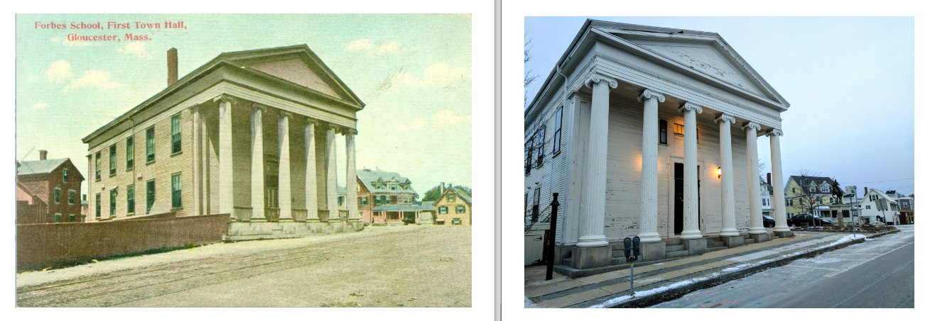
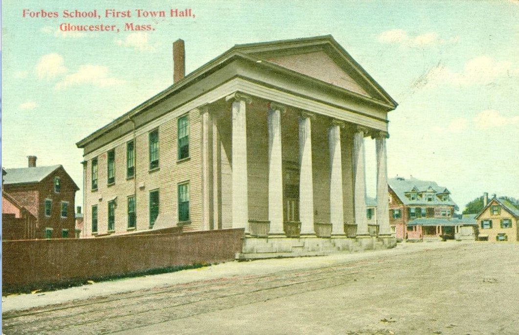
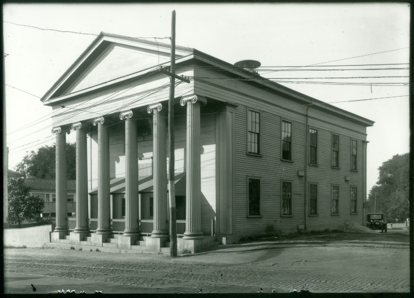
Washington St. at “the crotch of ye old highway”- Townhall | Forbes School | Legion

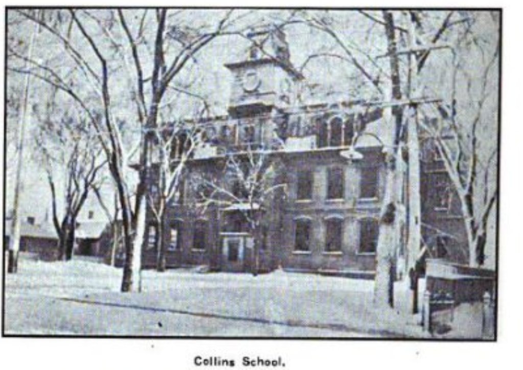
The frame was purchased from Rockport. The citizens of that town intended to build a town house before Gloucester, but decided to abandon the idea on economic grounds. It was occupied March 17, 1845. Previous to this, town meetings had been held in the First Parish Meeting House, Union Hall, the old Collins’ school-house and other places and at Sandy Bay before it was set off. Its cost was $4200. At a town meeting held in February, 1866, it was voted by a large majority to erect a new town house.
According to Pringle the frame of school then 1844 Town Hall / School House / now Legion was purchased from Rockport
Collins School
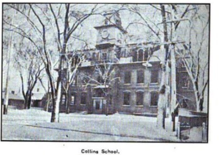
The Universalist edifice, as it stands now, the old First Parish church, with its pagoda like steeple, and the old Collins school house, standing on the site now occupied by the building of the same name, and the pride of the town, Tappan’s Hotel, were among the more noticeable features. Its name, like its predecessor, was derived from Madame Collins, who in the early part of the century gave the land upon which the building stands.
Pringle, 1892

“Grammar Pupils Taught How to Box Compass
If one were to look for a school for skippers he would naturally turn to Gloucester, but he would hardly expect to find the rudiments of the fishermen’s art taught in the public schools. But such is the fact. This “skippers’ class” has been for some years part of the regular course of the Sawyer grammar school, the progressive principal of which is N.D. Tingley…The skippers recite in one of the halls of the school, in the center of which is drawn a large compass encircled by an iron railing. This compass is some four feet in diameter, and all the points are given by their abbreviations in the same manner as on the regular mariner’s compass. In addition to the pole, as given by the needle, the true north is also indicated by a black line, the variation of the needle in Gloucester being quite marked, some 13.5 degrees…The class numbered a dozen, three quarters of whom were girls from 7 to 12. But before they had finished their lessons they demonstrated that they could give their brothers “points” in every sense concerning the boxing of the compass. Possibly Principal Tingley was giving a class of new women instruction in the art of navigation, for one of the first new women of recent times is a pilot on the Mississippi, and perhaps one may officiate in a like capacity aboard of a cape Ann fishing steamer… What is one point west of south? Five pointes east of north? Six points west of south, etc…After the skippers have become proficient and have been graduated they pass the “board.” The board in this case is Mr. Tingley, and he issues to the proficient graduate this certificate, which is highly prized by the holders, as it is printed on cardboard in gilt letters as follows:
Sawyers School Skipper’s Certificate–The Bearer, John Smith, having successfully boxed the compass and answered the required practical questions upon the same is herby awarded this Certificate of honor.–Gloucester, Mass., 1996.”
Boston Globe, 1896

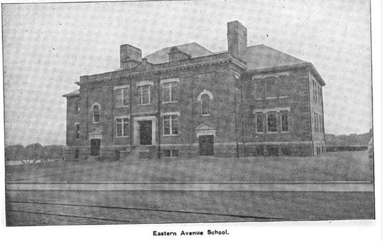
“Proposed New Grammar School in Ward 2, Gloucester
After much discussion the school committee and the public property committee have selected plans for the proposed schoolhouse in ward 2. The lot where the school is to be built is especially adapted for the purpose. It is on Eastern avenue nearly opposite Day’s pond, and commands a magnificent view in all directions, including an outlook of Little Good harbor beach and Bass rocks, which, from the contour of the lands, can never be shut out by building operations. The building will be 60 x 125. it will contain two main floors and a roof section, the latter being designed for a gymnasium or large hall should such be needed. In the basement will be the usual heating apparatus, the janitor’s room and separate playrooms, with accessories for boys and girls. On the two main stories there are eight rooms…On the second floor, besides the four main rooms, there is a library and teachers’ room…The exterior will be of the colonial style, the material being red brick, with stone trimmings. The estimated cost above ground clear of the furnishings is $31,000. It is intended to have the building ready for occupancy sometime next year. Taking the cost of furnishings and everything it is estimated that the entire cost will approximate 45,000.”
Boston Globe 1905
Gloucester history 1920 may just be as much if not more current than 2021
Furthermore, whereas formerly the majority of the people in Gloucester were native born, now 46.6 percent of the fathers of public school children are foreign-born: 19 nationalities are represented. They include the following countries, Canada, Denmark, England, Italy, Ireland, Finland, France, Germany, Greece, Iceland, Holland, Newfoundland, Norway, Nova Scotia, Portugal, Russia, Scotland, Spain, Sweden. The largest number are from Portugal, Italy, Finland, England.
From the standpoint of the school, this means that the educational problem is far more difficult than formerly. It means that the school must now not only teach the three R’s, but to use a much over-worked term, it must really be the “melting pot” of all these diverse elements. It must be a social agency in the community where all elements may meet on a common footing. It must be a school where the children may have the opportunity to develop the particular gifts, which all these different nationalities bring to America, rather than a dye vat where all these different vivid colors from all over the world are dyed into one monotone.
In other words, although Gloucester is a small town of only a few thousand inhabitants, yet from an educational standpoint it is faced with the same problems which confront school systems in the average city…”
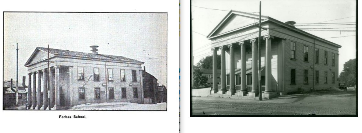
Regarding the high school on Dale and Forbes School Branches (multi building complex)
High School I claim for my administration a savings of $250,000 on the high school alone, and when completed we will have a high school building second to none in Eastern Massachusetts and at a cost of less than half what other cities are paying. And right here I wish to publicly commend and thank the teachers and scholars of our high school for the splendid spirit of co-operation and patience they are exhibiting in cheerfully walking back and forth through mud and rain. The school displaying such fine spirit deserves a good building, and I shall never forget their good and fine cooperation. Money cannot pay Mr. Ringer for his fine leadership in this school under very trying conditions, but now I wish he would confine his activities to the position he was hired for.
I think our school troubles are soon to be relieved. Mr. Fellows, our new superintendent, will, I hope, prove a second Putney. I hope to see our small neighborhood schools again running as under Mr. Putney. I believe, and I have letters from educators that agree with me, that a small school with two or three grades offers equal advantages to small children as single grade schools, as the lower grade pupils are all the time learning something from the higher grade recitations. With the completion of the Washington Street primary school, both the high and primary situation will be relieved, and those garages on the town landing will be taking out of our schools forever. And now with that building on the lot standing the city $5,000 (the cost of moving), does anyone think it should have been given away? For that is all the building stand the city—the cost of moving—for a foundation would have to have been built anyway.
Mayor Percy Wheeler Inaugural Address (2nd term)


woodcut illustration for 1890 Boston Globe article | photos: c. ryan, mostly 2021

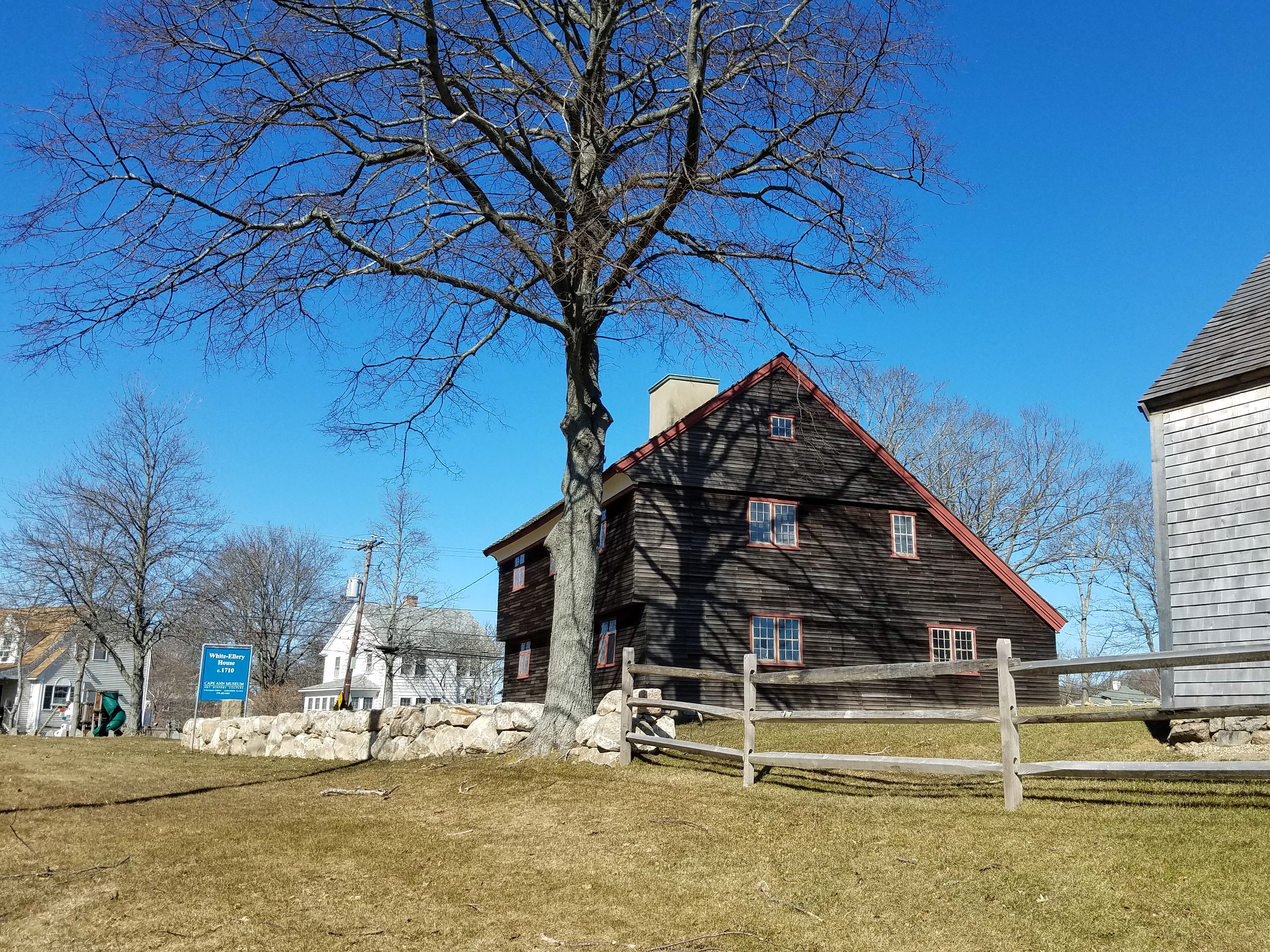
The first Massachusetts home featured in this Boston Globe historic house article was Gloucester’s “Ellery house”, as a classic First Period saltbox:
“OLD HOMES, OLD FAMILIES. Houses in New England, Each of Which Has for Three or More Generations Sheltered the Same Race. Romances Drawn from Wood and Brick
The Sunday Globe begins today to publish stories and pictures of old New England homesteads which have sheltered at least three generations of the families now living in them.
This is not so endless a task as some may suppose it to be. New England, no doubt, contains a greater number of old houses than any other division of the country, but it is rare indeed to find one among those that has been long in the possession of the same family. Such a shifting of ownerships may reflect the growing prosperity of the original occupants who perchance have built greater homes than those of their fathers, but often the disappearance of the inheritors of these ancestral houses signifies either the utter extinction or the scattering and breaking up of the family.
The sketches in this series opening today appeal, therefore, in a peculiar way to the public curiosity, and the Sunday Globe would thank any of its readers if they would call attention to any houses within their own knowledge which may be occupied by a family who have possessed the property through three or more generations continuously or otherwise.
There are various periods in the history of Gloucester house building, each marked quite as distinctly to the architectural student as the different strata of the earth’s crust indicate to the geologist the various periods of formation. In the case of the old houses of note it may be said that they all belonged to the upper crust.
The houses of the first settlers of Gloucester, with rare exceptions, have long since been replaced by others of more elaborate design, and the few remaining in the suburbs are small one-story edifices of no particular architectural pretensions.
In common with Boston, Salem, Newburyport and other colonial seaports, Gloucester once owned a large fleet of ships, brigs and barks, that sailed to foreign ports, exchanging the products of the town and of the county for Spanish gold and Surinam molasses, which was converted into New England rum.
These merchants built commodious residences and dispensed a hospitality commensurate with their position as leaders of the social and intellectual life of the town.
The most historic edifice in town is the Ellery house, which stands just below the old meeting house green on Washington street in Riverdale, a suburb of the town.
It was built by Rev. John White shortly after he came here in 1702 to minister to the spiritual wants of the First Parish, receiving a grant of land from the town on which to build his home. At that time the main settlement was in that portion of the community, but the necessities of commerce and fishing made it convenient for the inhabitants to remove nearer the seashore, deserting their first habitations on what is now known as “Dogtown Common,” where the remains of their cellars can still be traced today.
The type of architecture is well portrayed by the accompanying cut. On the projection which overhangs the lower story in front there were four balls pendant, a style of decoration of the times, which have long been removed.
Inside, the old-fashioned low studded style of room is at once apparent, and the antique furnishings and general air of the place make one realize more vividly the age of the house and fixtures, which are of a nature to bring joy to the heart of an antiquarian.
Some of the furniture in the parlor is about 200 years old. The house was bought in 1710 by Capt. William Ellery, and it still remains in the hands of his direct descendants, the occupants being John Ellery and his wife. Thus it will be seen that it has been in this family 150 years.
The purchaser of the house was a son of the original settler, William Ellery. The Ellery family were prominent in the social and intellectual life of the place from the first, being leading merchants. Hon. Benjamin Ellery, called in the family “Admiral,” was the eldest brother of William. He went from Gloucester and settled in Rhode Island and was the father of Deputy Gov. William Ellery and grandfather of William Ellery who signed the Declaration of Independence, the signer being a grandnephew of the first owner of the house.”
Boston Globe 1890*
Read the full article (PDF) to see the other Massachusetts homes selected for the article.
The Declaration of Independence connection was artfully slipped in. Fast facts on the signers from the National archives here.
The White Ellery House is part of the Cape Ann Museum collection. There are inaccuracies in the 1890 nutshell above. James Stevens and the tavern he operated is absent. The rum trade is acknowledged; any NE slave trade economic connections are not. [Massachusetts was the first colony to legalize slavery. Vermont was the first to abolish (VT 1777 vs. MA 1783).] The article predates the build out of Rt. 128 which rallied a preservation relocation.
Maybe CAM might commission a set of woodcuts of the historic properties as they are now by various local artists.
Beautiful improvements on the grounds of Cape Ann Museum


")
note: pinch and zoom or double click to enlarge photos.

Then and now.


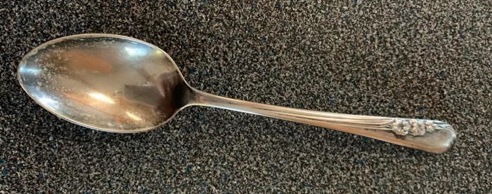
In 1952*, Art Jewelers on 117 Main Street (now Unwind) in Gloucester, Massachusetts, offered GHS female graduates a FREE sterling silver teaspoon in a pattern of their choice.
Pauline Bresnahan writes about a great conversation she had with her mother this week: “We were talking about running a small business on Main Street today compared to when she was growing up here. She told me about the following story which I had not heard before. My Mom Graduated GHS in 1952. Art Jewelers on Main St. offered each Female Graduate a FREE Sterling Silver teaspoon in a pattern of their choice. My Mom picked Blossom Time, an International Silver Co. pattern. She and my Dad were married in 1953 and by then purchased 7 more teaspoons. They were gifted more place settings as a wedding gift.”
Other businesses catered to students, too. Gloucester Pants Co. at 211 Main Street advertised “special rates to students” in the yearbook. Nichols Candy and Luncheonette was across the street in 118 Main Street, where Franklin is now. There were several jewelers on Main Street. (Pauline worked at Blanchards and remembers her boss taking them to Cameron’s for celebrations.)
*How many possible spoons? The GHS1952 senior class size looks to be > 250 inyearbook.


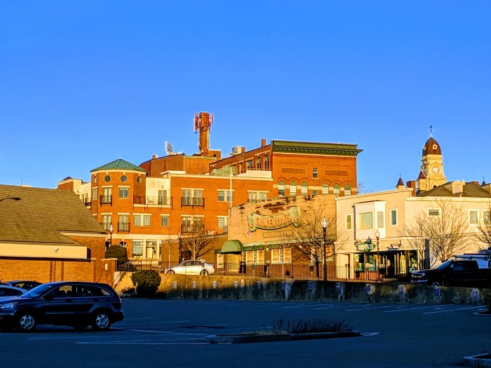
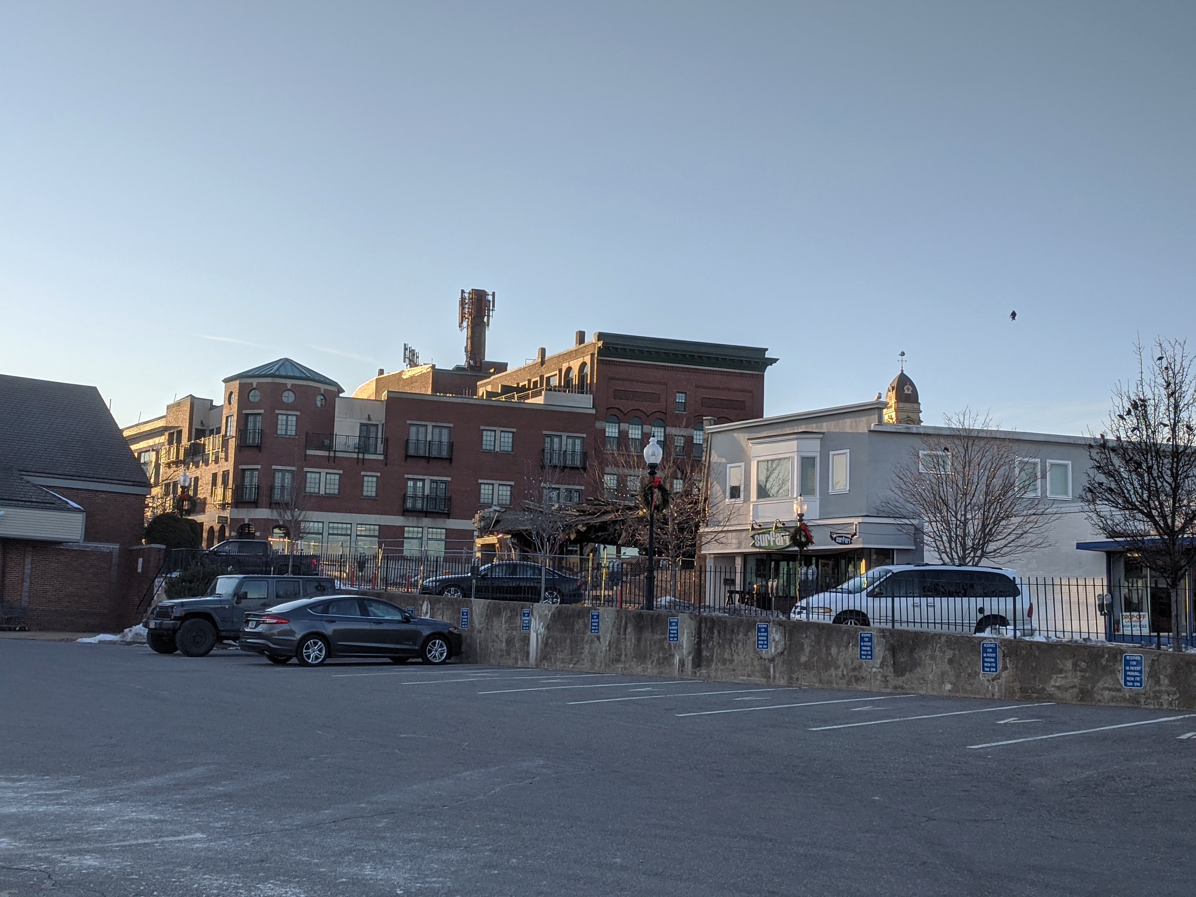
Debris from the demo of the 13,500 SF property (and parking lot) on 206/209 Main Street, formerly known as Cameron’s restaurant, is being trucked away from sorted piles, scrap metal here, mixed materials there. Action Inc. and North Shore Community Development Coalition ‘s new apartment building will meld in a few street level commercial spaces. (Read about the latticework of buildings on this stretch of Main here and see photos then and now below. I think it will be both changeless and changing as the saying goes.) I’m confident the charm and great karma of Cameron’s meals and happy celebrations will carry forward for the residents and business owners coming to this corner of Main and Elm.
In the meantime I was delighted to find some (poor) snapshots with my mom inside Cameron’s. I’m sure there are more and better Cameron’s photographs out there!

")
")
")
")
")

photo snapshot captions – fuzzy glimpses of Cameron’s restaurant interior on St. Patrick’s Day 2009 (kids playing fiddles now in their 20s!) & 2010. There must be photos out there!
The eagle was removed, repaired and painted in 2017 in preparation for a new and most fitting site– flying high for Cape Ann Veterans Services. Who carved Cameron’s iconic eagle sign?
")


GMG reader David Collins shares the answer about the artist who hand carved the eagle as reported in the Gloucester Daily Times 2017. Carl Goddard of Nahant carved the eagle in 1967.


")

")

")

")
Artist studios across the street will have a front row for the construction progress.

Near Allen Street
")

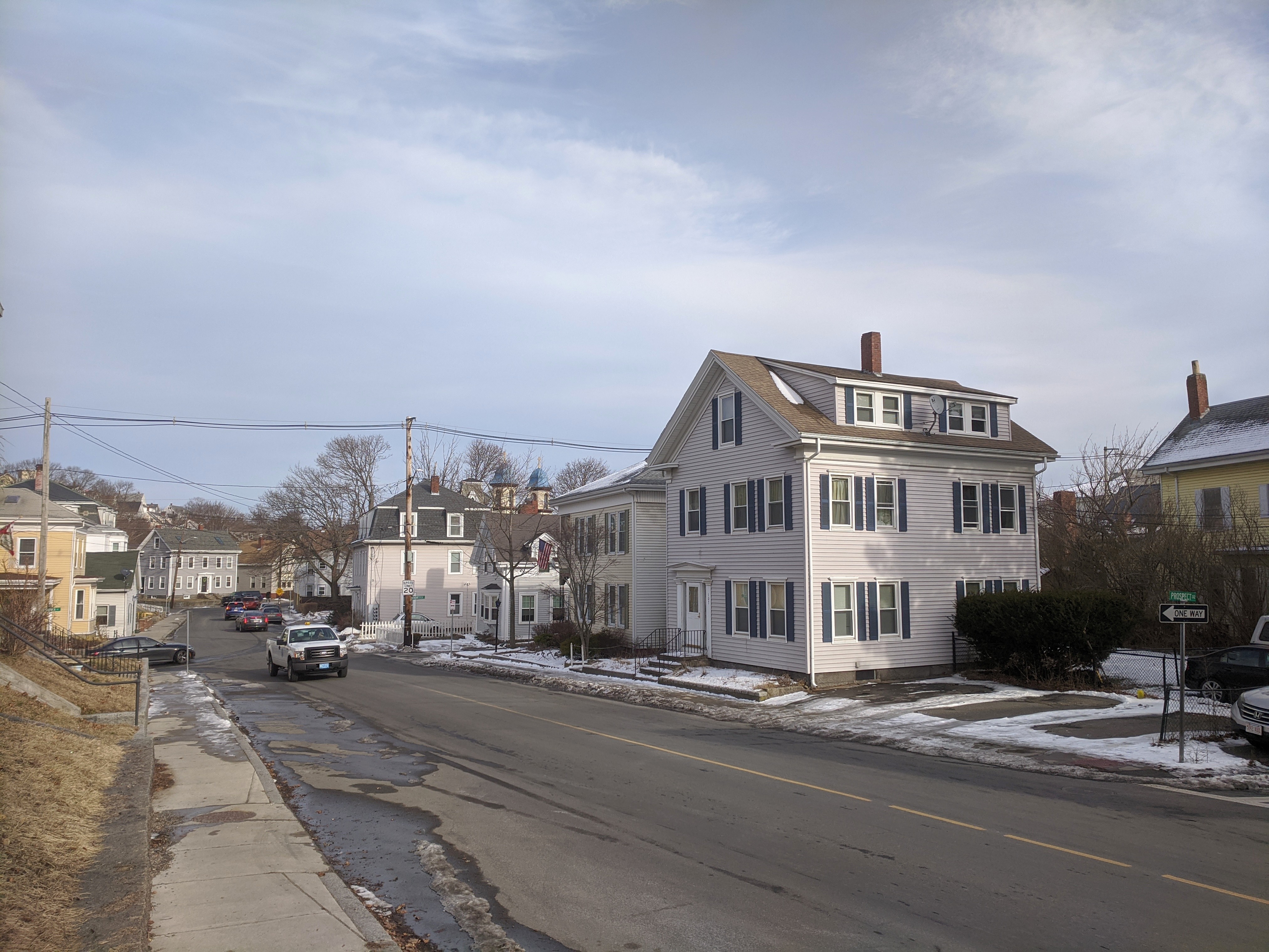
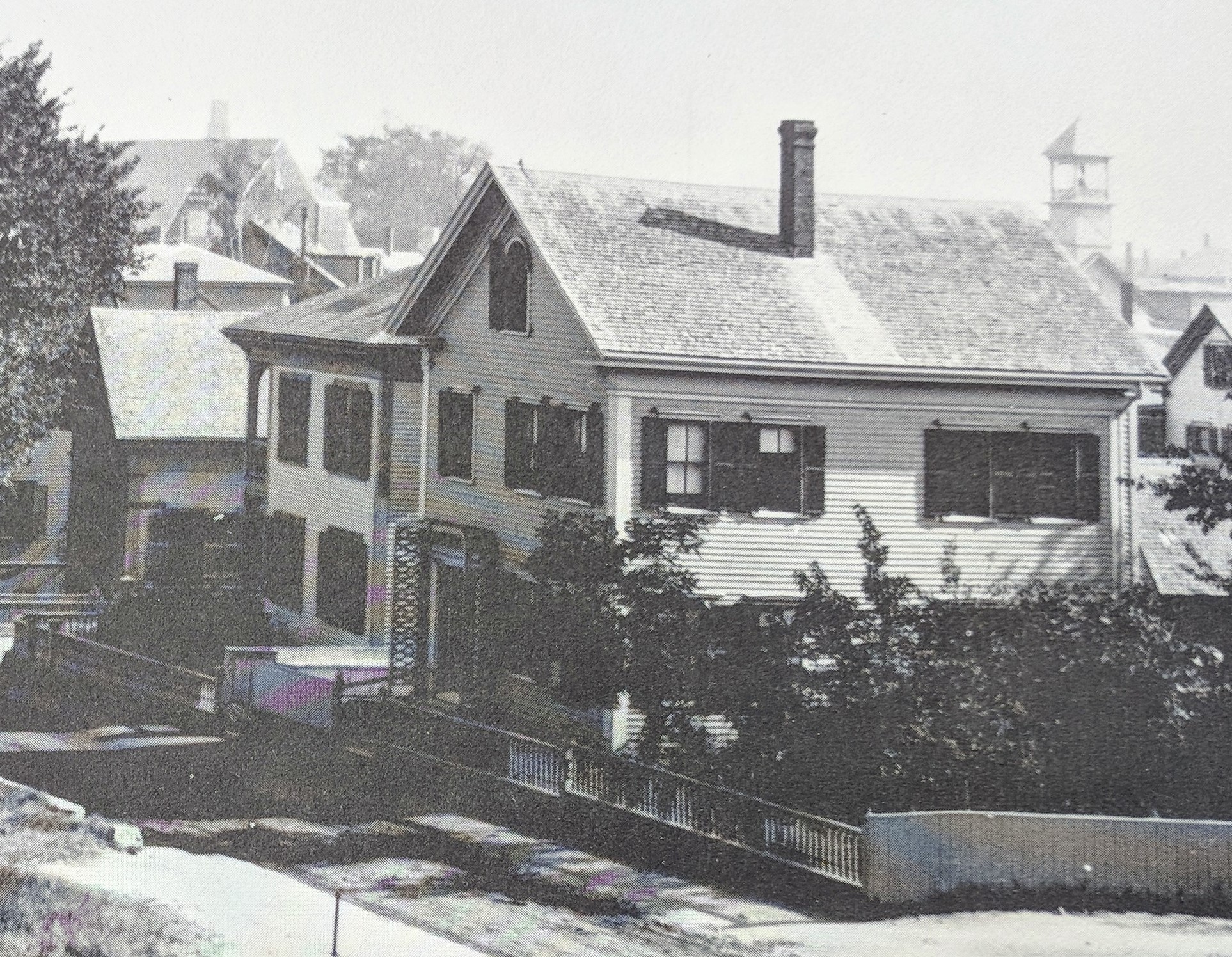
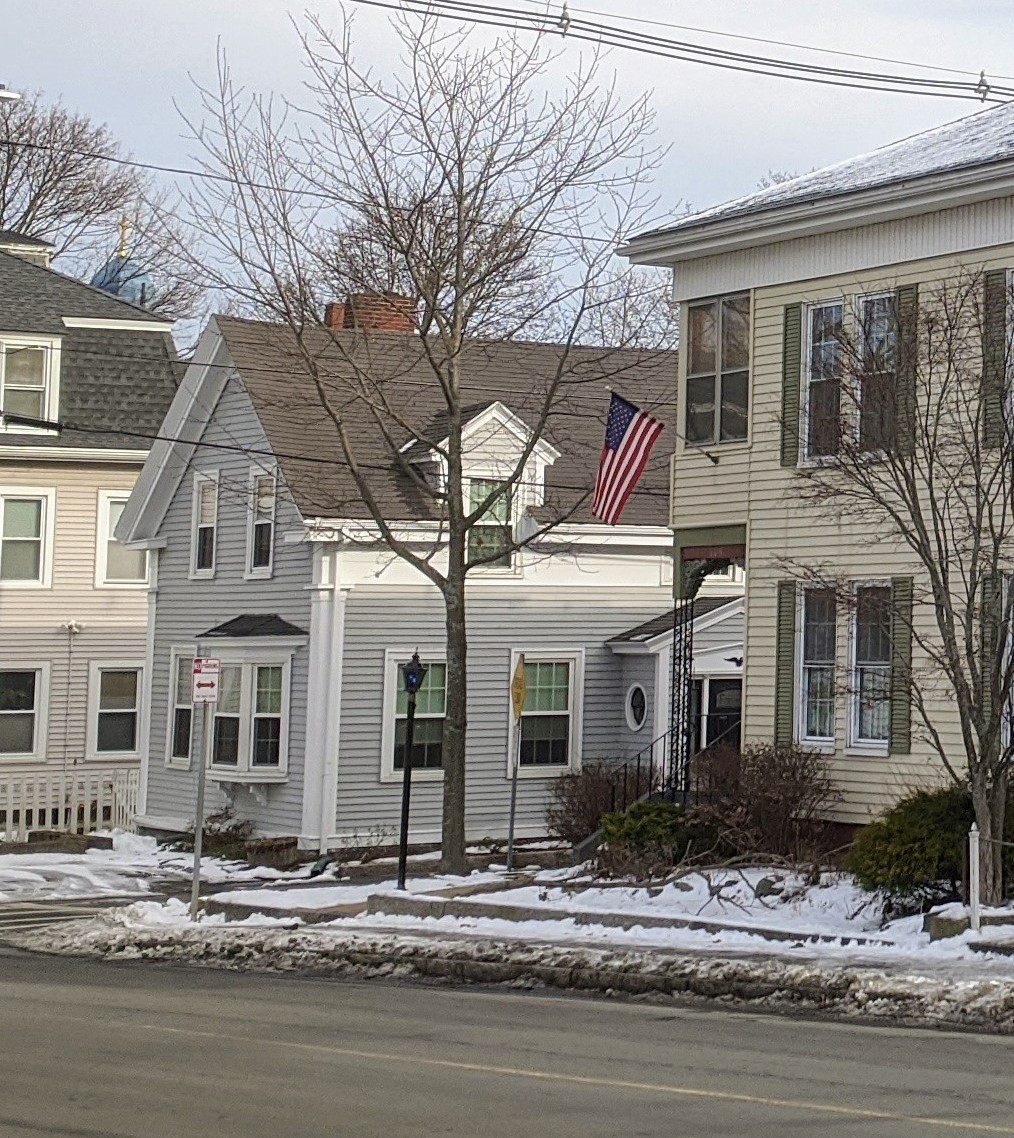
Below- arch windows and decorative door elements on the homes in the vintage photo can be found on homes throughout Gloucester, including two nearby:


")


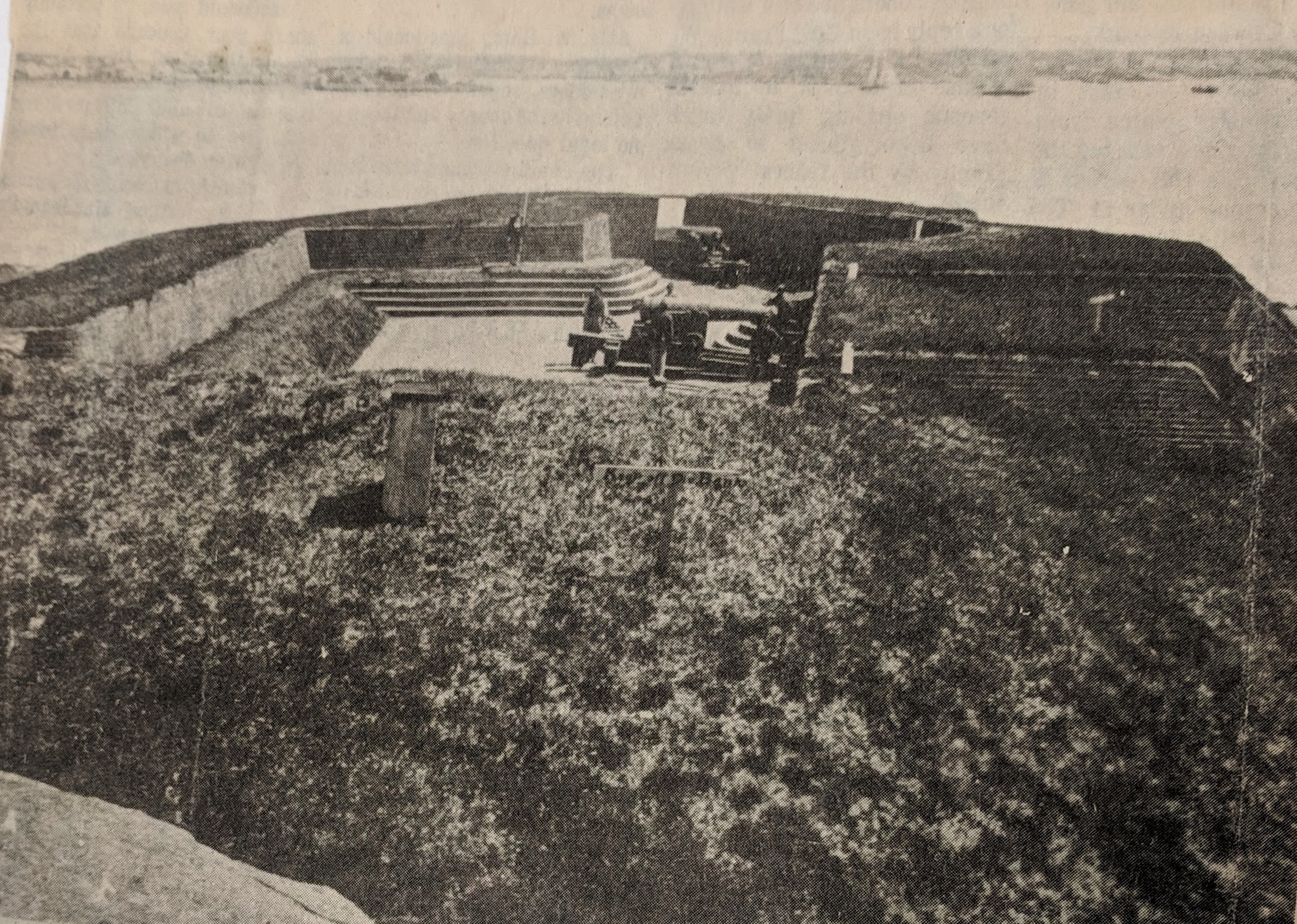
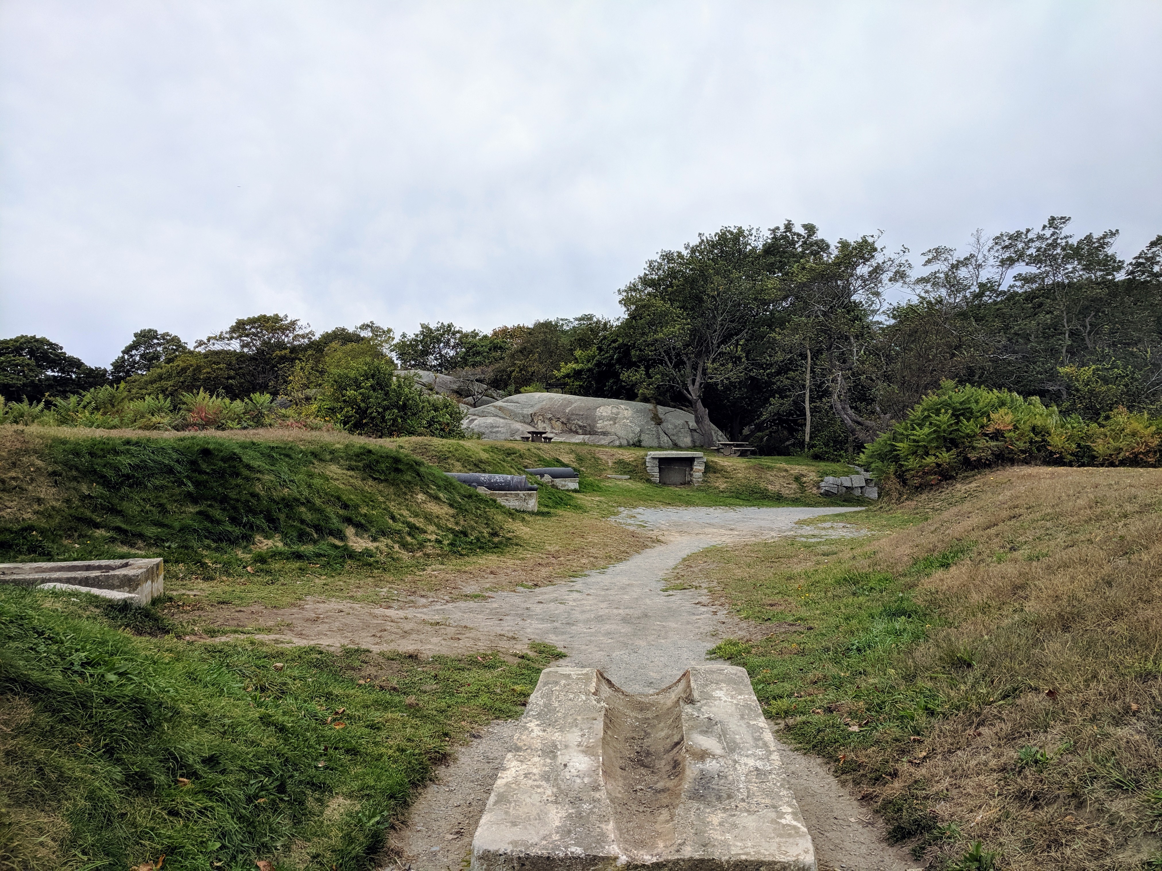


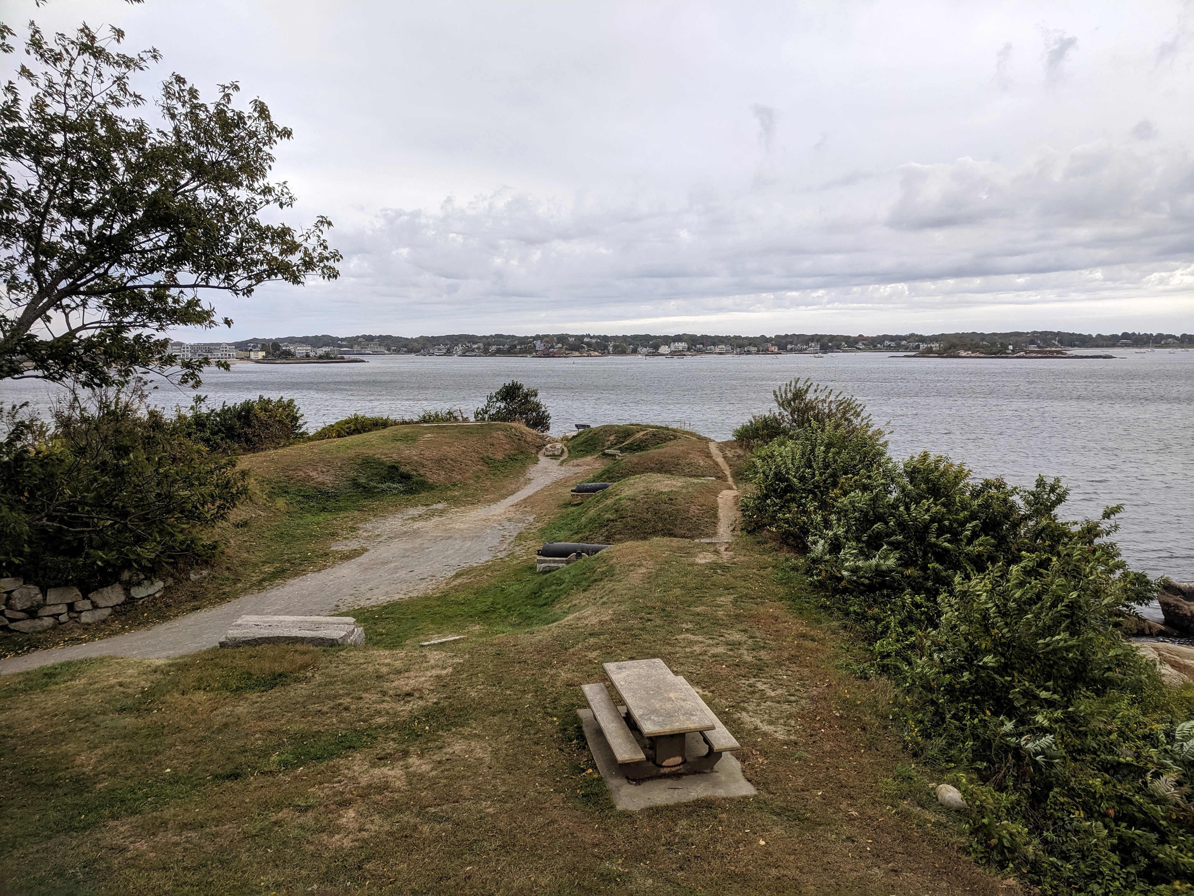
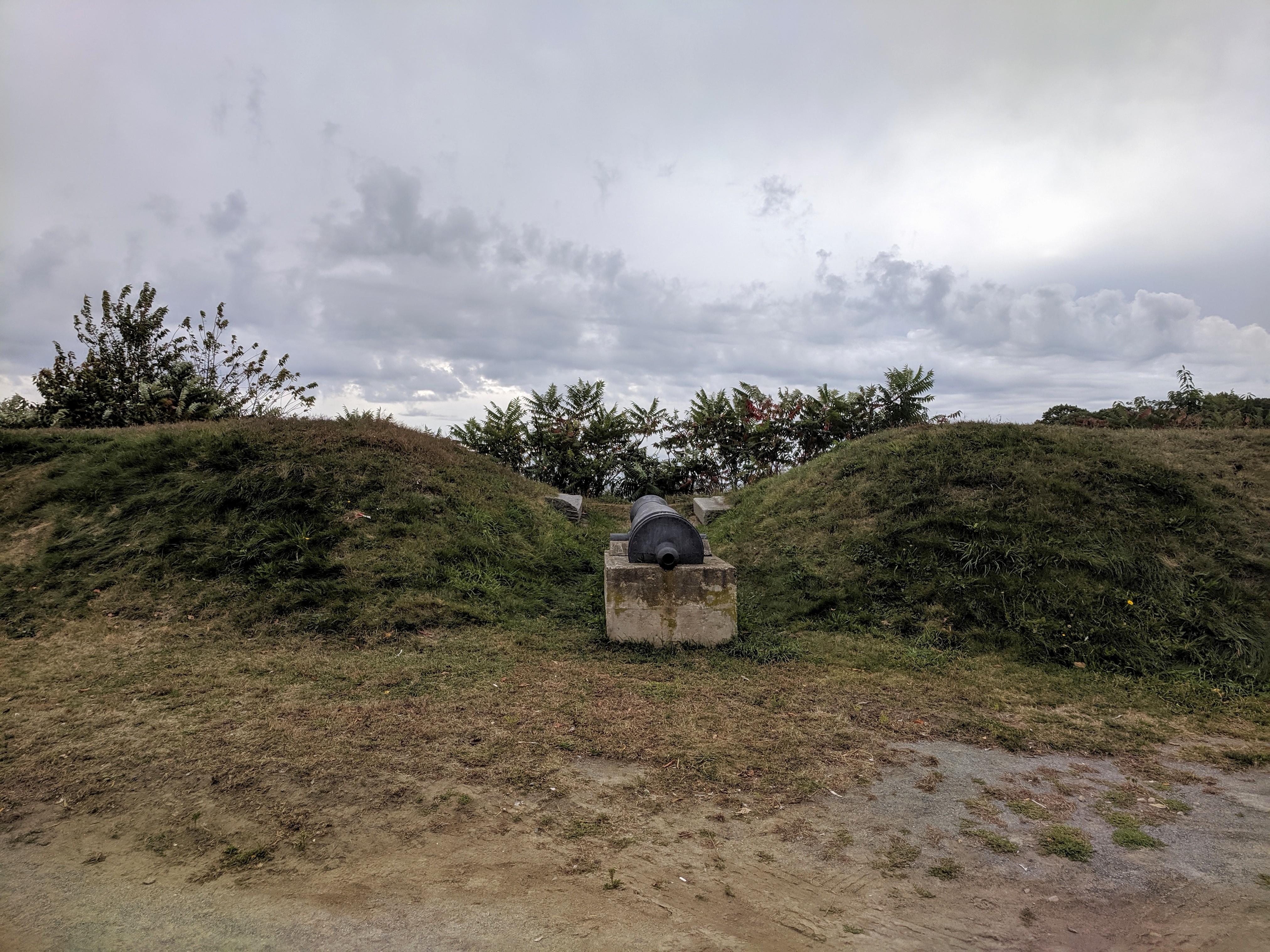
Sam Novello asks GMG, “Joe, what happened to the cannons at Stage Fort Park—— two are gone?”
The cannon(s) are undergoing restoration (cleaning, chemical treatment and re-painting). In 2018, the CPA Committee awarded $22,705 of an estimated $46,000 to the Stage Fort Park Advisory Committee to refurbish the Parrot Rifle Cannon for work scheduled to commence spring 2020. The project is led by the Stage Fort Park Advisory Committee. The grant application project summary indicates the scope of work as follows:
“Our final goal is to restore the Fort area as a historic feature of the Park and its importance to our local military history.* Repairs and restoration of this site are long overdue. The ramparts are overgrown with vegetation**. The cannon barrels are suffering due to neglect. The barrels are subject to trash, dirt and debris. We hope to preserve this site for future generations. The cleaning, capping and painting of the cannon will protect the barrel against future damage. We have proposed an annual stipend in the city budget of $2000 for maintenance of the Fort as well as a security plan for the Fort which would include lighting and security cameras. *Our ultimate goals include a visitor education center with historic references to the Fort and its history. It is expected that the entire Stage Fort Park will be used as a centerpiece of the city’s 400th anniversary celebrations.”


– Stage Fort Park Advisory Committee CPA application excerpt, photo from packet and phasing goals
Read the full application here: 2019 CPA Application SFP Parrot Rifle Cannon Carriage
*There is no finalized plan for this area overall. (See photographs then/now below.)There IS a history of Fort use and restoration for historic battles –as well as city celebrations– honoring this legacy and the kind souls who volunteered to do so.
For example: I’m not sure if the 187th Infantry Brigade was paid for the work they did in 1973, which I’m assuming was the last big overhaul. The CPA grant is just about the work on the cannons. The Historical Commission wrote a letter of support stressing replica accuracy using period materials (wood and metal)
**The area is overgrown at the moment because of various DPW work on the boulevard and future plans. (When I photographed the area annually it’s cleared.)
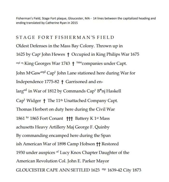
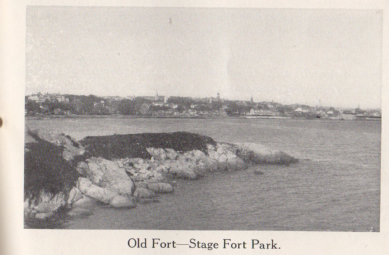
Stage Fort is the oldest fort in the Massachusetts Bay Colony.
")
")
As part of the city’s 350th celebration prep, the cannon site area (earthworks, entrance area, powder magazine, and gun embrasures) was restored by an engineer brigade from Wollaston. The design intent turned the clock back to how the fort would have been built out in the 1700s. Julian Hatch, the chairman of the 350th, had been director of public works for the city. The project was decades in the wishing and sensitively designed at long last.
In 1930, the Fort was spruced up from its formal design post Civil and Spanish war. Fisherman’s Field Stage Fort information plaques were commissioned and unveiled.
Bronze tribute plaques embedded in Tablet Rock at Stage Fort Park detail the site’s history and were commissioned and unveiled at different times. The monumental and stunning Founders plaque from 1907 on Tablet Rock itself is in fantastic condition. Two DAR plaques were inlaid on the glacial outcroppings past half moon beach on the way to the cannons. The Fisherman’s Field (ca.1930) is so worn it’s nearly indecipherable, though that’s part of its charm. The plaque compels close inspection, lingering and discovery. It’s a fun family activity for anyone who likes a challenge. For those who want help reading the content, I transcribed it back in 2010. ”
Printable PDF of the plaque translation here
Read more about historic battles and Gloucester Stage Fort Park in this trivia quiz designed by Shaun Goulart, GHS history teacher, in this prior GMG post.
copy of Frank L. Cox fine art photograph (pre dates 1921) he used to illustrate his pocket Gloucester guide “The Gloucester Book”, and sell prints


Gloucester, Mass. A great teacher at Gloucester High School, Shaun Goulart, creates a local history scavenger hunt/trivia game for his 9th grade students that takes place weekly for 6 weeks.
ANSWERS TO SHAUN GOULART’S LOCAL HISTORY SCAVENGER HUNT TRIVIA WEEK SIX. THIS CHALLENGE IS THE FINAL WEEK IN THE SERIES. GO BACK HERE IF YOU WANT TO SEE WEEK 6 QUESTIONS ONLY.
The challenge Week 6 was to locate the historic map on Cape Ann Museum’s Fitz Henry Lane on Line and study it closely to comb through location prompts. This is a great family activity for all ages. It’s a bit eye spy or Where’s Waldo mixed with atlas map fun. The students were tasked with photographing the same sites as they appear today and creating a labeled presentation.
Visit CAPE ANN MUSEUM FITZ HENRY LANE ON LINE resource and scroll down to the correct map here
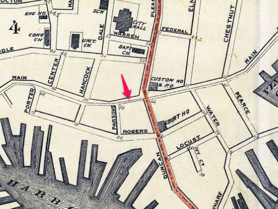
Map of the Towns of Gloucester and Rockport (detail of Harbor Village)
Henry Francis Walling (F. Walling)
1851
44 x 34 in.
Henry Francis Walling, Map of the Towns of Gloucester and Rockport, Essex Co. Massachusetts. Philadelphia, A. Kollner, 1851
Cape Ann Museum Library & Archive
“Map of the Towns of Gloucester and Rockport, Massachusetts. H.F. Walling, Civil Engineer. John Hanson, Publisher. 1851. Population of Gloucester in 1850 7,805. Population of Rockport in 1850 3,213.”
Map detail = segment of Harbor Village portion of map showing Lane-Winter property on Duncan’s Point.
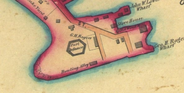
| Question – find on 1851 historic map | ANSWER- NOW (2019) | |
| 1 | Duncan’s Point | Maritime Gloucester / Railways (former FG Low’s & Eli F. Stacy’s whf) |
| 2 | Five Pound Island | State Fish Pier |
| 3 | Front Street (present sign must be in picture) | Main and Short |
| 4 | Middle Street (present sign must be in picture) | Middle Street |
| 5 | High Street | School Street and Proctor |
| 6 | Fort Defiance | The Fort |
| 7 | Vincent’s Cove | West End Main Street and Rogers section all fill / Gorton’s, Americold, etc |
| 8 | Town House | Legion |
| 9 | Gloucester House | Brick building corner of Washington and Main (Puritan House) |
| 10 | Two cemeteries | 1)cemetery next to Amvets on Prospect 2)St. Ann’s |
| 11 | Hospital | up Granite Street veers right to Blyman |
| 12 | Town Landing | Same (St. Peter’s) |
| 13 | Two bowling alleys | 1)on Stacy Boulevard (see Cordage manufactury below)
2) on the Fort |
| 14 | 3 schools | study the map! 1)by Univ Church and Eng H& School on Church off Middle on old map 2)looks like where Central Grammar is 3)Prospect and School where apartments are now 4)corner Washington and Gould Ct. |
| 15 | Train station | Roughly train platform now |
| 16 | Engine house | Beyond train platform- roughly where Stop & Shop is on RR Ave |
| 17 | Canal Street | Stacy Boulevard (Tavern side) |
| 18 | Cordage Manufacturing | Ditto |
| 19 | Beach Street | Commercial Street (behind Beauport Hotel back to water) |

Gloucester, Mass. A great teacher at Gloucester High School, Shaun Goulart, creates a local history scavenger hunt/trivia game for his 9th grade students that takes place weekly for 6 weeks. We’re taking the challenge paced one week after the students.
ANSWERS TO SHAUN GOULART’S LOCAL HISTORY SCAVENGER HUNT TRIVIA WEEK FIVE
1)What year was there an ordinance to establish a Police department in Gloucester? ANSWER: 1873 (according to the Gloucester Time Line archives book and the great Gloucester police website here : “In 1799, Isaac Elwell was appointed Inspector of Police. This was a term first used in Boston 14 years earlier to describe the men appointed to keep track of the night watchmen who patrolled the city after dark watching for fires. Constables assisted Elwell and other men who followed him as Inspector of Police until about 1847 when a petition was received by the Selectmen asking for some additional policemen to assist the Inspector of Police. Around 1850 the first night police were used. Only a few of the policemen were paid as the rest either served without compensation or were only paid for working during special occasions. In 1873, a city ordinance establishing a police department was put into effect with nine officers under the leadership of City Marshal William Cronin.”)
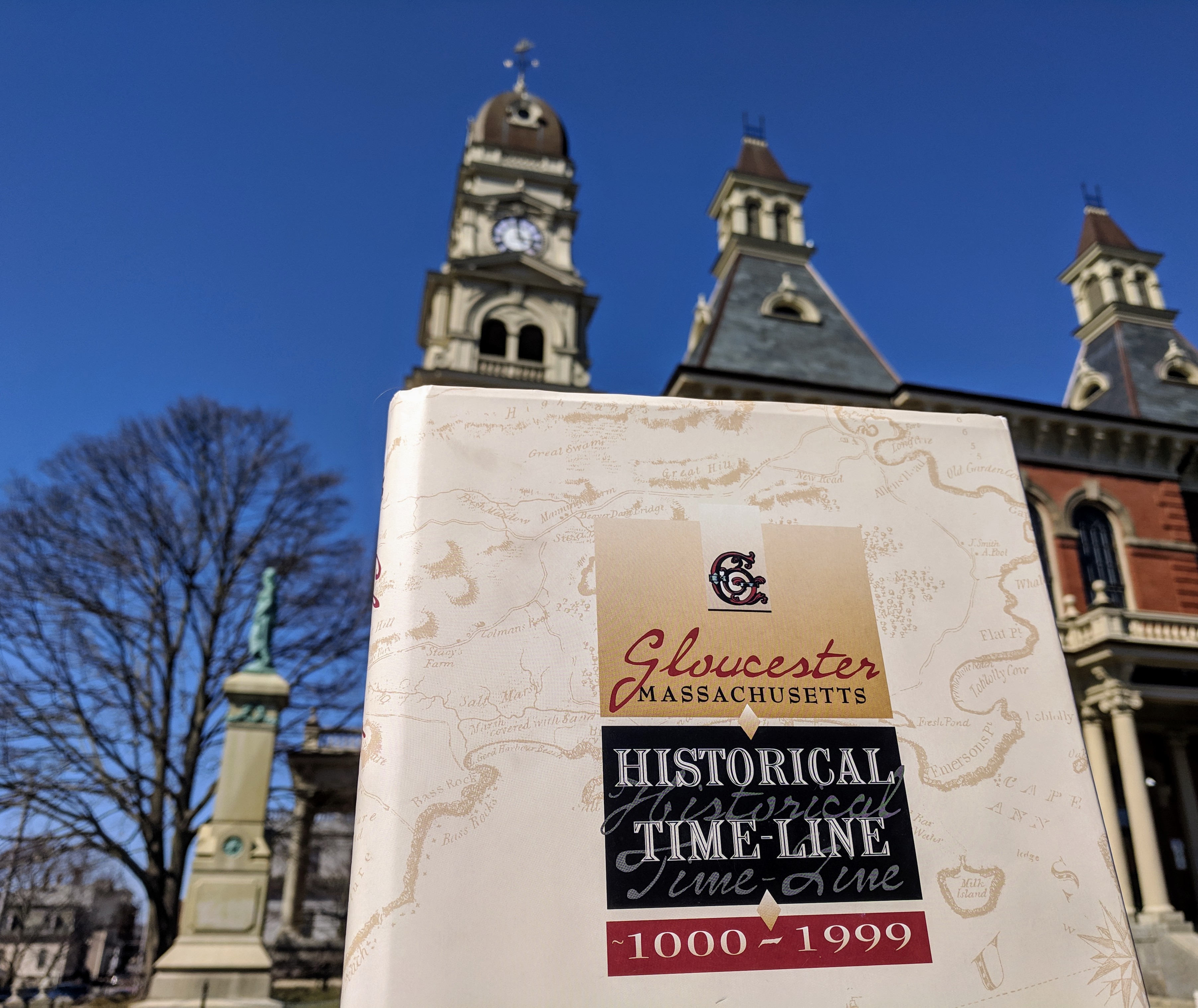
2)The original building used as a jail prior to 1889 was located on Rogers Block, take a picture of this area present day with a member in it. ANSWER: Main Street (harbor side) from Duncan to Porter


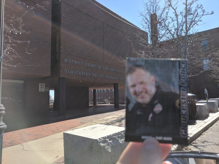
3)Where was the first Gloucester police station built in 1889, take a picture with a member in it at the location. ANSWER: corner of Duncan and Roger


4)Veterans of what war had a hall for them located on the third floor of the building? ANSWER: Spanish American in the police station that was built in 1899. City Hall Read about bronze veteran tribute plaques (including Spanish American) at City Hall here
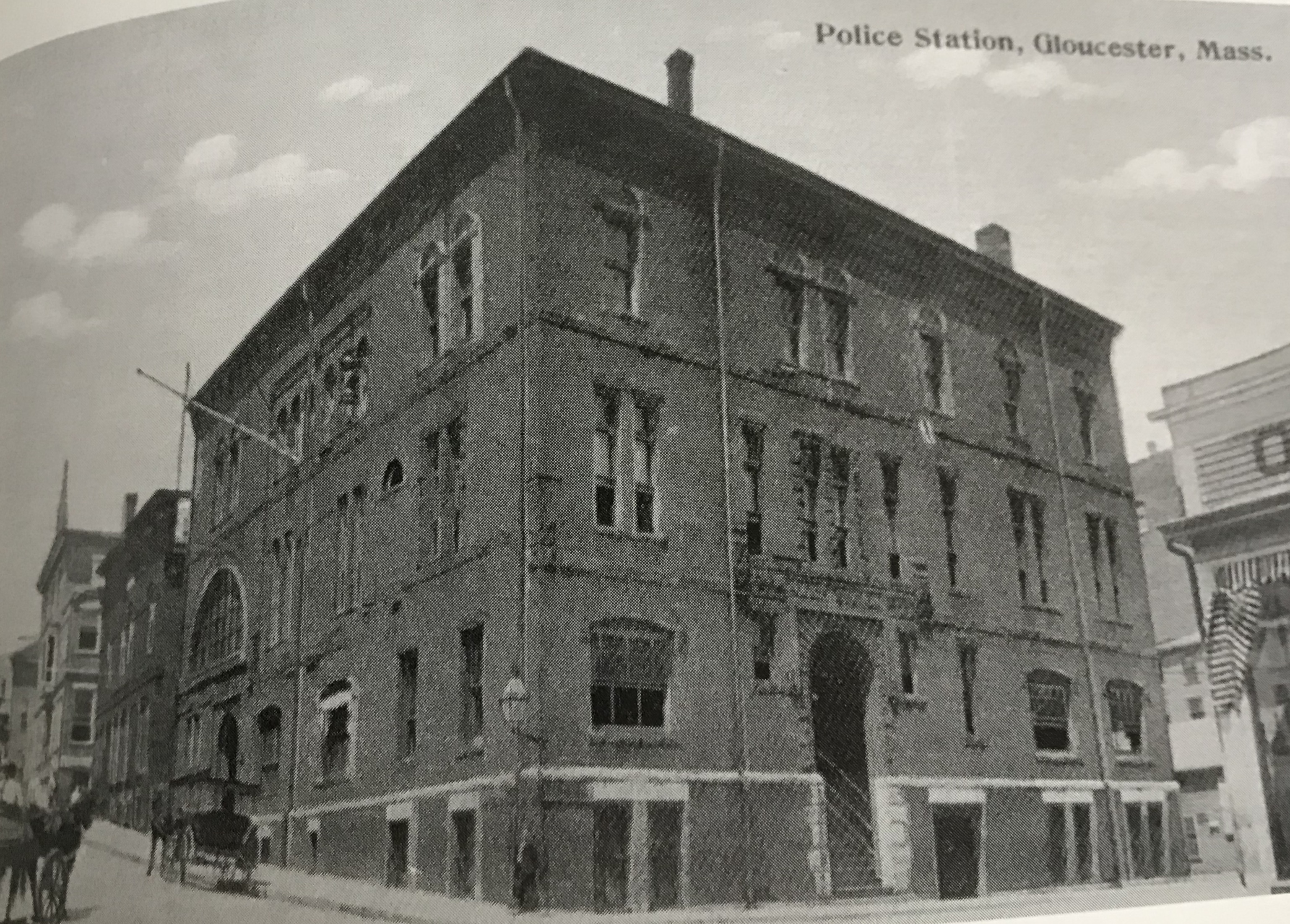
1971/1973 newspaper clipping from Sawyer Free
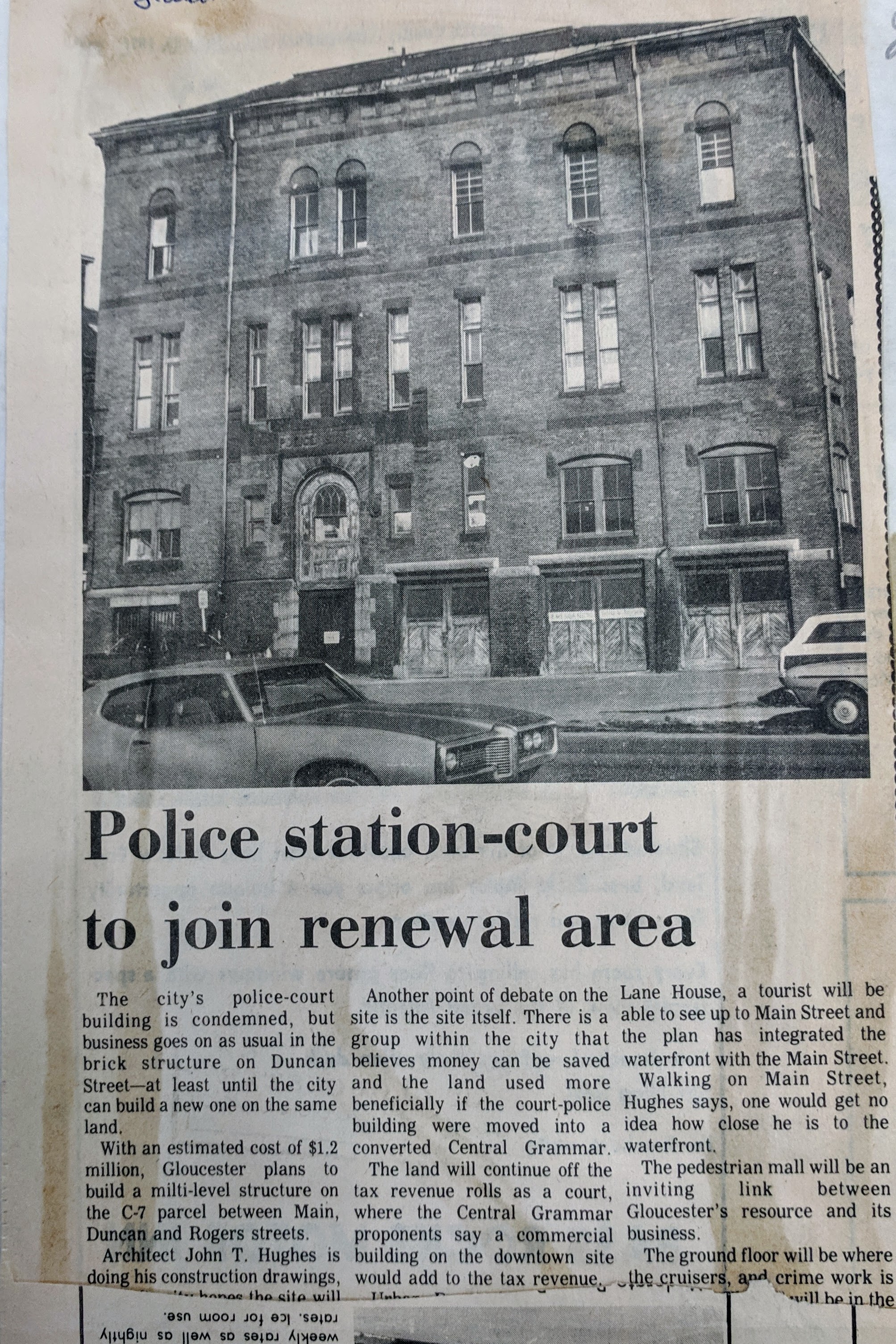
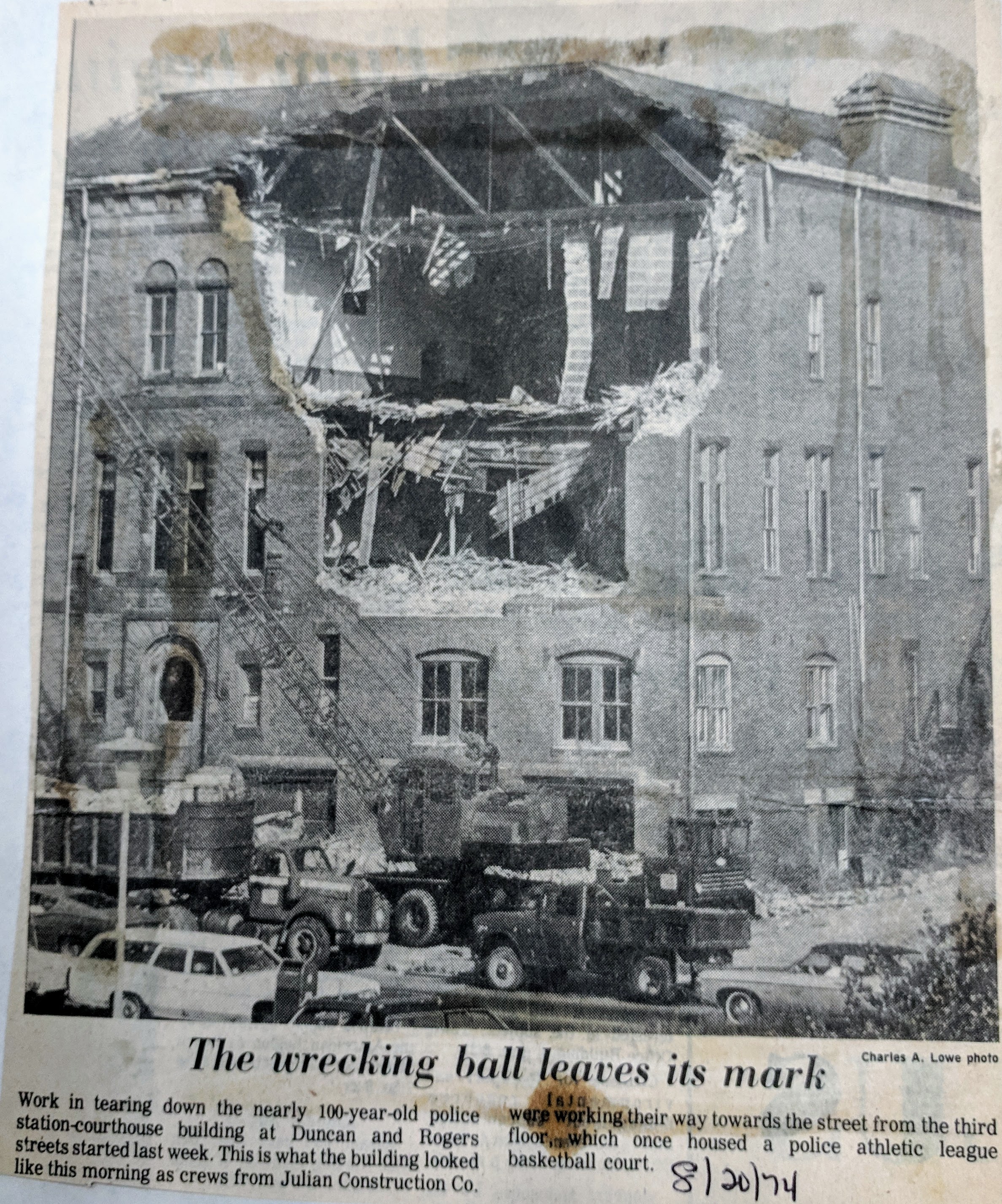
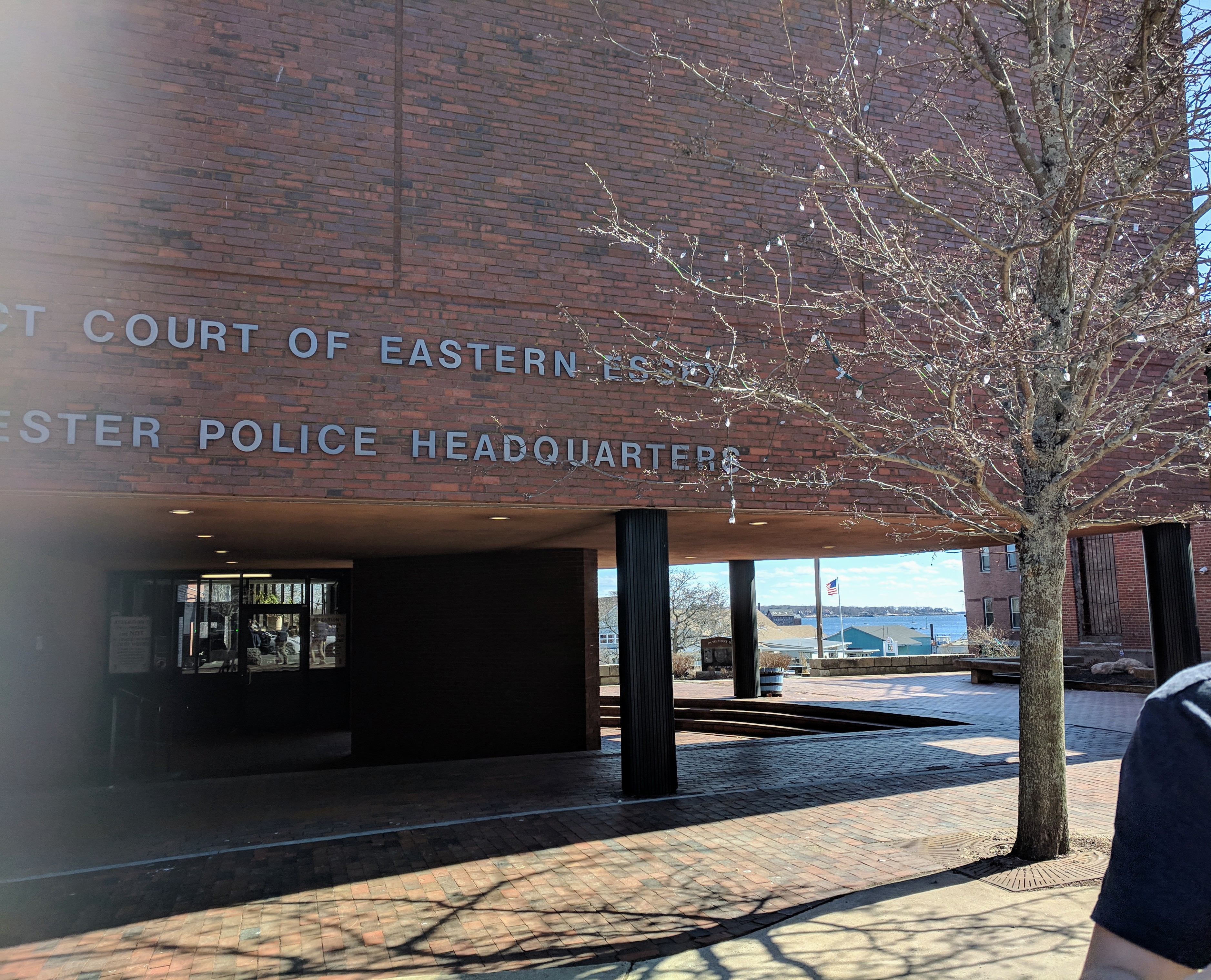
5)What year was the present day police station erected? Take a picture of it with a member in it. ANSWER: 1973
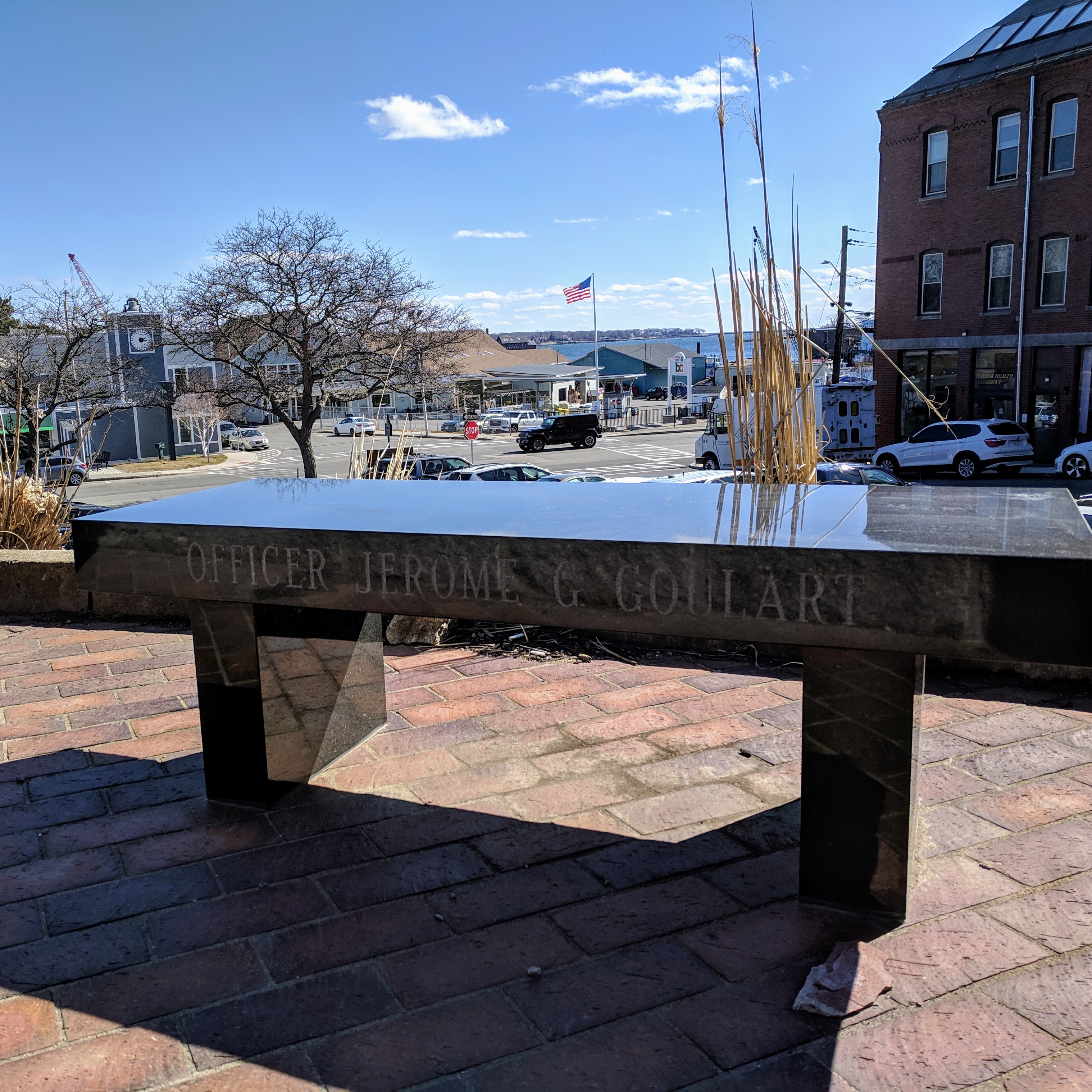
6)Go to the exterior of the police station and take a picture with an object that would be personal to Mr. Goulart (keyword: Goulart) ANSWER: Officer Jerome G. Goulart memorial bench
7)Take a picture with a Gloucester Police officer in uniform. Answ. How cool are these officer baseball cards!
")
")

“Kops-n-Kids” is a Gloucester Police Department (Official) initiative where officers visit Gloucester Schools to interact with students during recess & gym class
8)Ask the cop: What is the code word for “lunch break” over the radio. Submit the answer. ANSWER: 1093
9)For a brief time the “Old Stone Jug” served as a jail, take a picture in front of it with a member in it. What is this building known as? ANSWER: Fitz Henry Lane former house and studio
10) Where does the term cop come from? ANSWER: not definitive though according to snopes meaning “nab” closest: “Instead, the police-specific use of “cop” made its way into the English language in far more languid fashion. “Cop” has long existed as a verb meaning “to take or seize,” but it didn’t begin to make the linguistic shifts necessary to turn it into a casual term for “police officer” until the mid-19th century. The first example of ‘cop’ taking the meaning “to arrest” appeared in print around 1844, and the word then swiftly moved from being solely a verb for “take into police custody” to also encompassing a noun referring to the one doing the detaining. By 1846, policemen were being described as “coppers,” the ‘-er’ ending having been appended to the “arrest” form of the verb, and by 1859 “coppers” were also being called “cops,” the latter word a shortening of the former.”- snopes
Prior Posts Continue reading “RESULTS Week 5 Police | #greatteacher Mr. Goulart’s local history hunt #GloucesterMA #TBT”

Gloucester, Mass. Great teacher at Gloucester High School, Shaun Goulart, creates a local history scavenger hunt trivia game for his 9th grade students that takes place weekly for 6 weeks. We’re taking the challenge paced one week after the students.
ANSWERS TO SHAUN GOULART’S LOCAL HISTORY TRIVIA WEEK FOUR
How did you do? Week two delved into Gloucester’s famous inventors. Stop here if you prefer to go back to see Week 4 questions only
Mr. Goulart’s Local History Trivia Scavenger Hunt Week 4 Inventors
1.John Hays Hammond Jr. “Jack”
Go to the location of his home and take a picture with a member in it.
Answer: “Over the course of his professional career, he was awarded over 800 foreign and domestic patents resulting from over 400 of his inventions. Many of these began in radio control before extending to electronics, naval weapons, national defense, as well as various consumer products.” – Hammond Castle
“In connection with his radio researches Jack obtained most important patents for receiving and broadcasting and these he sold to RCA…” John Hays Hammond, Sr
Hammond Castle – I hope that one day the Trustees and Historic New England add this as a shared property among their preservation jewels, along with the Natalie Hammond property and much of the parents’ estate, Lookout Hill, with some portion of admission for the City. At one point Hammond Castle was one of the top attractions in Massachusetts.
")
")
")
")
")
")
")
")
")


")
2.Clarence Birdseye
Go to the location where his company was and take a picture with a member in it.
What did he invent?
Answer: flash freezing

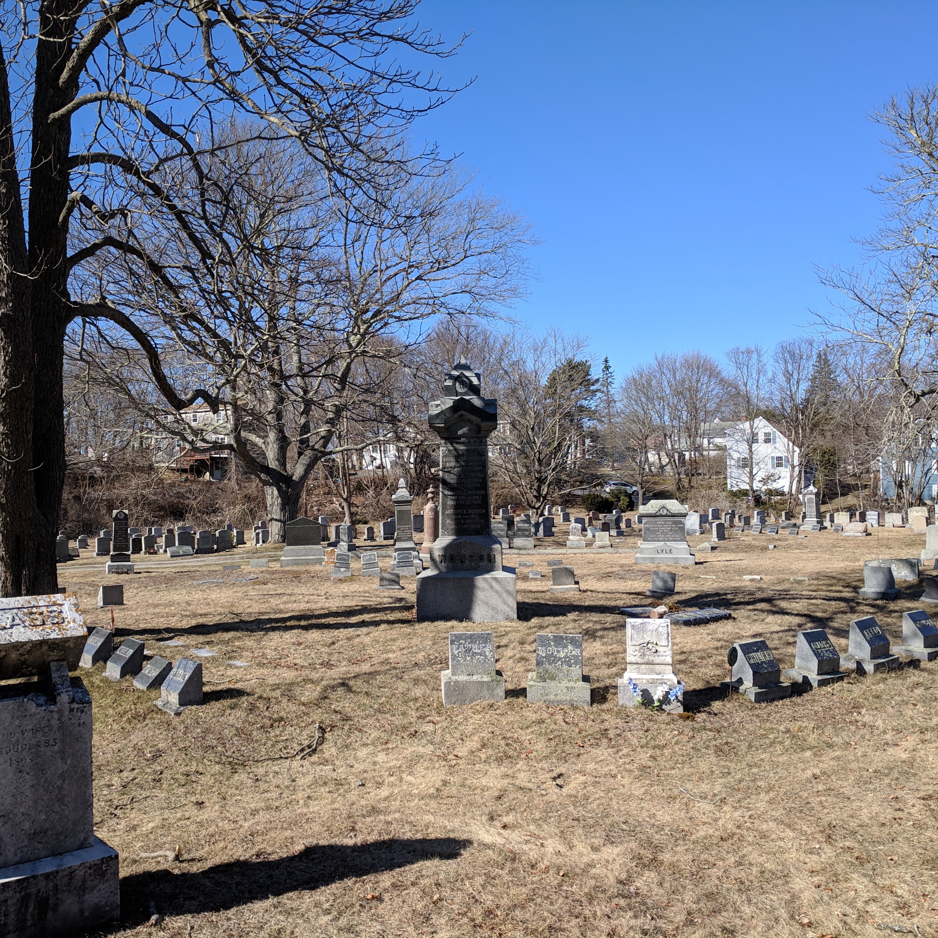
3.Augustus H. Wonson
Go to the location of his grave and take a picture with a member in it.
Answer: Mt. Pleasant cemetery
What did he invent?
Answer: Augustus S Wonson invented antifouling copper paint to protect boats. Tarr & Wonson’s was established in 1863. The former factory and harbor icon is now Ocean Alliance.
Paint Factory Past/Present
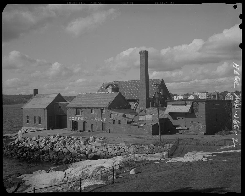
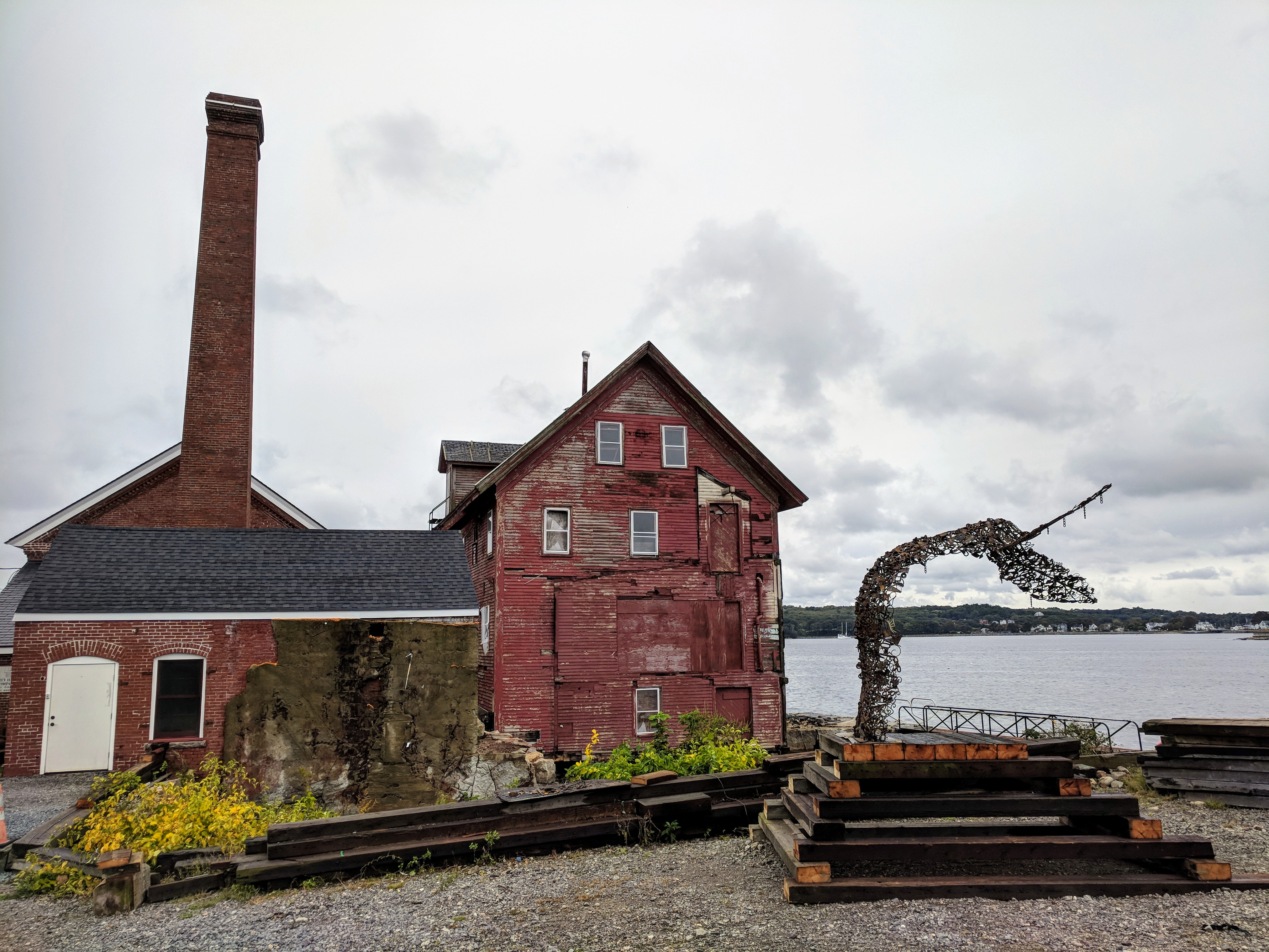
Paint Factory Ocean Alliance_2018 09 28_ Goetemann artist Deborah Redwood public art – whale’s tail in process_Gloucester, MA © catherine ryan
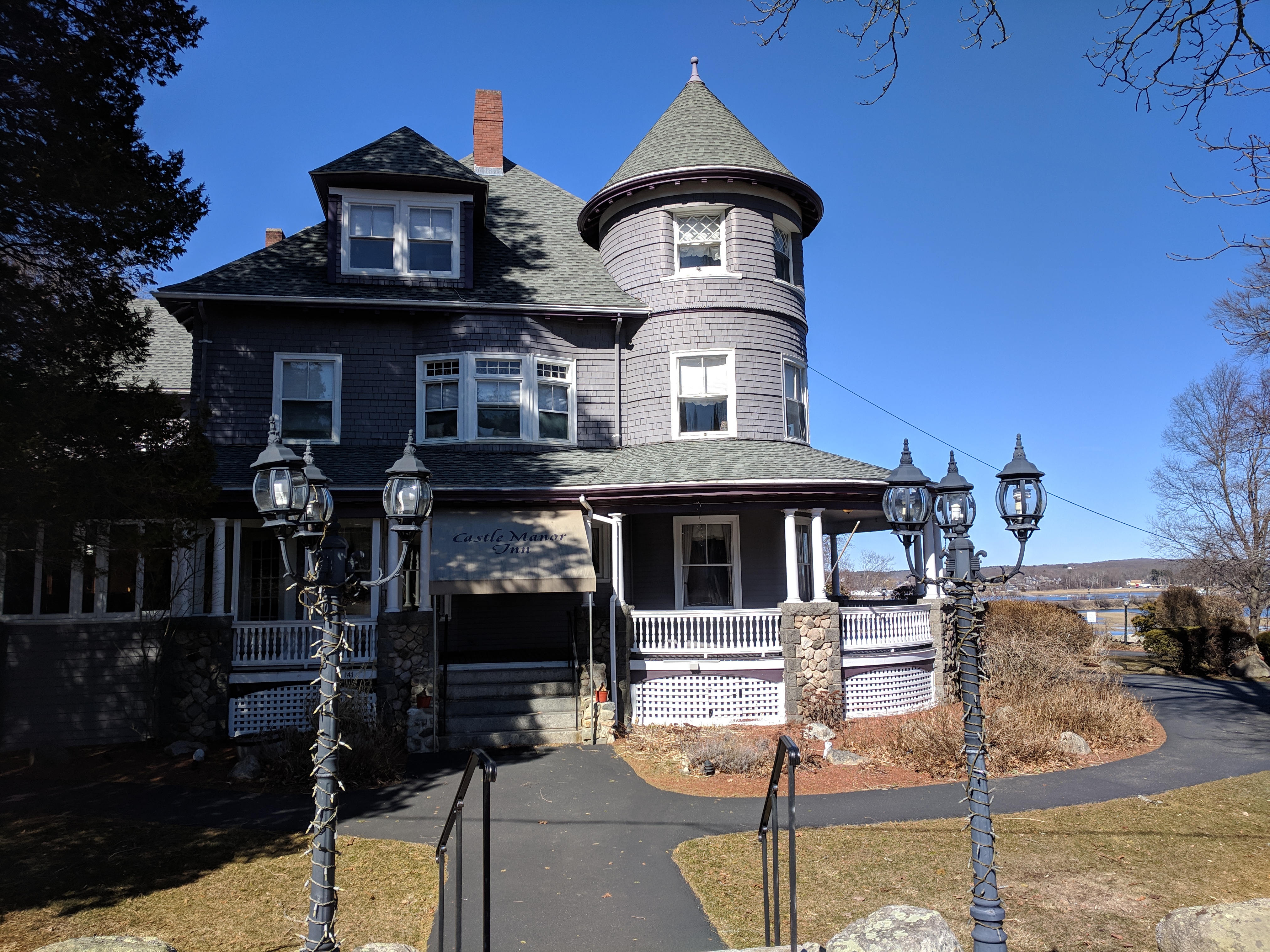
4.William Nelson Le Page
Go to the location where his company was after it moved from Rockport and take a picture with a member in it.
What did he invent?
Answer: Le Page’s glue from fish waste (established 1876)
Answer: Castle Manor Inn


Gloucester, Mass.- Great teacher at Gloucester High School, Shaun Goulart, creates a local history scavenger hunt trivia game for his 9th grade students that takes place weekly for 6 weeks. We’re taking the challenge one week after the students. Good luck!
ANSWERS TO SHAUN GOULART’S LOCAL HISTORY TRIVIA WEEK THREE
How did you do? Week three was all about some famous Gloucester FIRSTS and there were many locations. Stop here if you prefer to go back to see Week 3 questions only.
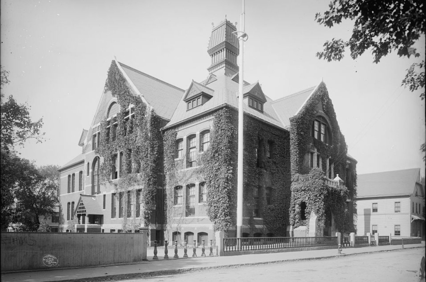
Principal Albert Bacheler CENTRAL GRAMMAR

PURITAN HOUSE built in 1810 by Col. James Tappan* is a historic house at 3 Washington Street and 2 Main Street. Also known as: Tappan’s Hotel, Gloucester Hotel (“Tappan’s Folly”), Atlantic House, Mason House, Community House, Capt Bills (1960s-70s), Puritan House & Pub (1977), Blackburn Tavern (1978-00s) *Tappan was taught by Daniel Webster
Excerpt from prior GMG post (read it here) about scenic tours by bike 1885: “And now let’s take our wheel for a short run along our harbor road to East Gloucester, and note the many points of interest on the way. The start is made at the Gloucester Hotel–the headquarters of all visiting wheelmen in the city–at the corner of Main and Washington streets; from thence the journey takes us over the rather uneven surface of Main street, going directly toward the east. In a few minutes we pass the Post Office on the left, and soon leave the noisy business portion of the street behind us, then, e’re we are aware of it, we reach and quickly climb the slight eminence known as Union Hill…” This brick building at Main and Washington now features Tonno Restaurant. Notice the chimneys and same stairs as when it was the Gloucester Hotel. The Blackburn Tavern sign was just marketing; this building has no connection. Blackburn’s Tavern is now Halibut Point restaurant at the other end of Main Street.


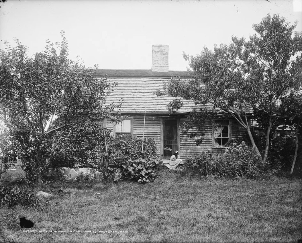
“RIGG’S HOUSE” 27 Vine Street (Annisquam) Thomas Riggs House purchased in 1661
oldest house on Cape Ann, Gloucester, MA

Look under the year on cenotaph surrounding Man At Wheel

Our Lady of Good Voyage – read more http://gloucester.harborwalk.org/story-posts/sp-20/
Subshop with a view- through Destinos window

1644! – 103 Centennial Drive – top of Centennial Drive near the train bridge


ANSWERS TO SHAUN GOULART’S LOCAL HISTORY TRIVIA WEEK TWO
How did you do? Week two delved into scenes of historic battles. I’ve added some background. Stop here if you prefer to go back to see Week 2 questions only from 3/17/19
*“In 1623, 14 English fishermen set up the first European colony on Cape Ann here in what was then Fisherman’s Field and is now Stage Fort Park. These ramparts overlook the harbor, first built during the Revolutionary War, renewed for the War of 1812, the Civil War and the Spanish American War. Alas, those first settlers, sent across the ocean by the Dorchester Company, were unable to live off the sea and these rock-bound fields. They moved a few miles south to what is now Salem in 1626. Then, within a decade, there were enough permanent settlers on Cape Ann to incorporate the town of Gloucester. The first meetinghouse was built on the Town Green in 1642 near what is now the Grant Circle rotary of Route 128. The City set this land aside as a public park in 1898 and its Tablet Rock was dedicated by Henry Cabot Lodge in 1907. James R. Pringle was designated to write the inscription for the bronze plaque. The execution of the design was by Eric Pape. “The nautical scheme of decorative framework and embellishment was the composite suggestion” of various committees dating as far back as the 1880s.” *see Gloucester HarborWalk Stage Fort Park marker #42 photo on marker ©Sharon Lowe. See also Stage Fort Park then/now photos in prior GMG post
Bronze tribute plaques embedded in Tablet Rock at Stage Fort Park detail the site’s history and were commissioned and unveiled at different times. The monumental and stunning Founders plaque from 1907 on Tablet Rock itself is in fantastic condition. Two DAR plaques were inlaid on the glacial outcroppings past half moon beach on the way to the cannons. The Fisherman’s Field (ca.1930) is so worn it’s nearly indecipherable, though that’s part of its charm. The plaque compels close inspection, lingering and discovery. It’s a fun family activity for anyone who likes a challenge. For those who want help reading the content, I transcribed it back in 2010. Scroll down below the “read more” break in this post to open.


location 2 courtesy photos
")
")
")
“In 1743, what is known as the old fort on Commercial Street, now encroached upon and surrounded by buildings, was completed. On this point, well selected strategically, is a hill which effectually commands the inner harbor. In 1742 and 1742, the General Court appropriated 527 pounds to defray the cost of fortification. Breastworks were thrown up and eight 12-pounders placed in position in the fort. The immediate cause of its erection was the fear of French incursions, but these fears were never realized. An effort had been made as early as 1703 to fortify the place, but the petition of the selectmen to the General Court for an appropriation for the purpose was refused. The petition shows that he harbor, even at that early date was extensively frequent for shelter, and was “very seldom free from vessels.”
“In order to be better prepared for future assaults breastworks were thrown up at Stage Fort, the Cut, Duncan’s Point and Fort Point. This, however was the last attack by sea or land that the people experienced.”
“Immediate action was taken toward the erection of fortifications. Land at Eastern Point, belonging to Thomas Niles was acquired by the government, and earthwork fort erected and manned…”
")
")
")


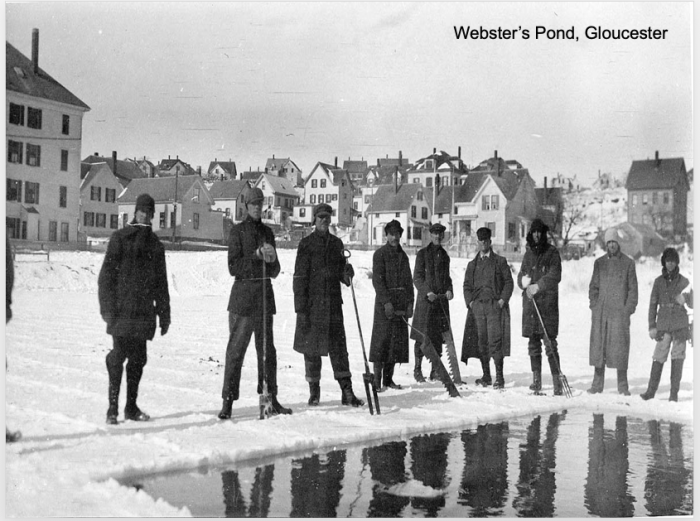
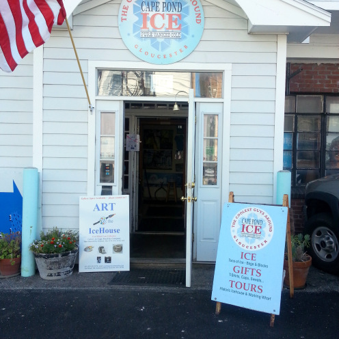
How did you do? Week one delved into the history of Cape Pond Ice. More than one player “had to call a friend”, Scott Memhard, owner of Cape Pond Ice and City Councilor. He kindly shared supplemental archival material included in this post. Stop here if you prefer to go back to see questions only from 3/10/19 Week One trivia questions
Continue to scroll for the answers.
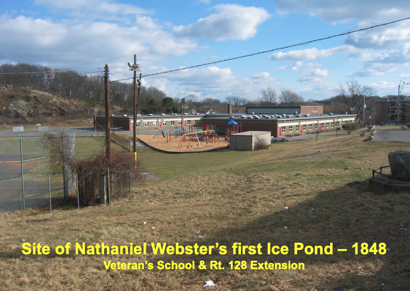
1)In 1848 a blacksmith named Nathaniel R. Webster started a company by damming a local brook. What did the brook become known as? ANSWER. VETERANS ELEMENTARY SCHOOL CAMPUS
2)What did Webster’s company become known as? ANSWER. CAPE POND ICE
3)Take a picture at the present day location of the company
4)Take a picture of the street named after him with a member in it. ANSWER. WEBSTER STREET
5)What is in place of the brook today? MATTOS FIELD- ABOVE = FRAT CLUB AND BELOW EVENTUALLY LEADS INTO LITTLE RIVER AT GOOD HARBOR BEACH
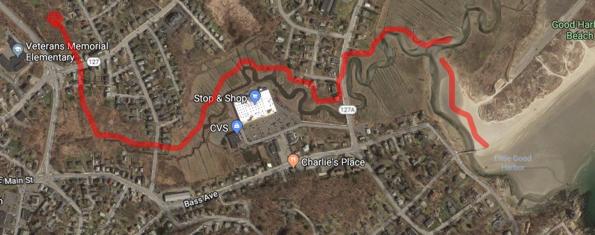
6)Take a picture at the location of the old dam with a member in front. ANSWER. THE SCHOOL
")
")

PART II
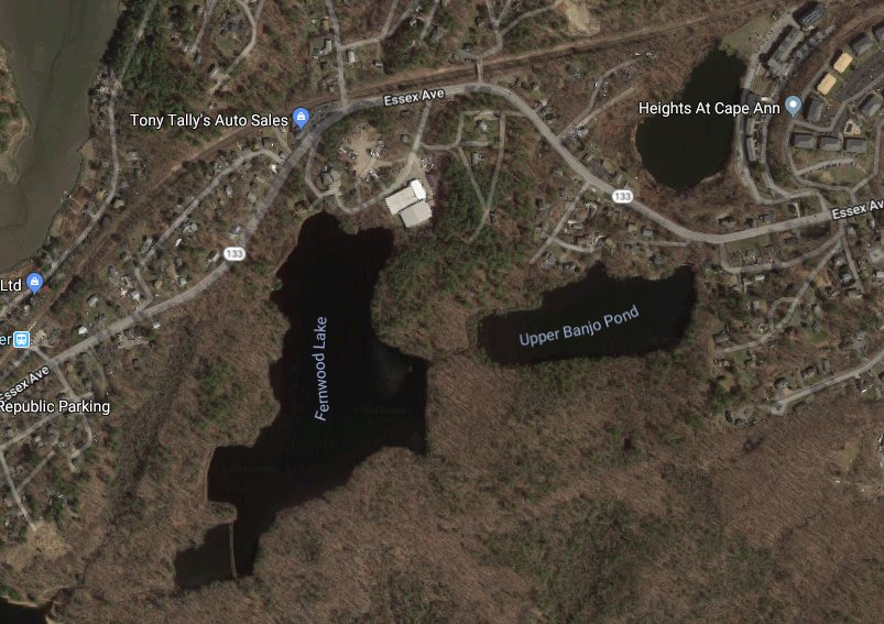
7)A competitor to Webster named Francis W. Homans in 1876 created a 32 acre man-made lake. What is the lake known as? ANSWER. FERNWOOD LAKE


8)Submit a screenshot of a map of the lake (Google Maps or Google Earth)
9)What year did the two companies merge? ANSWER. 1908
Courtesy photos below from Scott Memhard, Cape Pond Ice, Cape Ann Museum
")
")


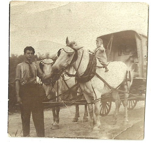
Courtesy photo from David Collins-
“My grandfather, Millard Collins, Sr., worked for one of the ice houses for a while. He died in 1918 at age 29 in the Spanish Flu pandemic. At that time he was working for LePages’s and had taken a leave of absence to care for his brother, Jacob, who had contracted the flu first. Jacob died October 17, 1918, and my grandfather died October 28, 1918…”
“I’m enclosing a picture of my grandfather and his horse-drawn ice wagon. You can see the word “ICE” faintly written on the inside back of the wagon. The youngster atop the horse is my father, who was born in July,1912, so I date the picture to about 1913 or so.”
Prior Posts
3/10/19 Week One trivia questions


ED Hanson and Tyler Garbo

Ed Hanson’s first day trip at Stage Fort Park May 20th 1948. Pictured is Ed at ten months old with his mother and father.

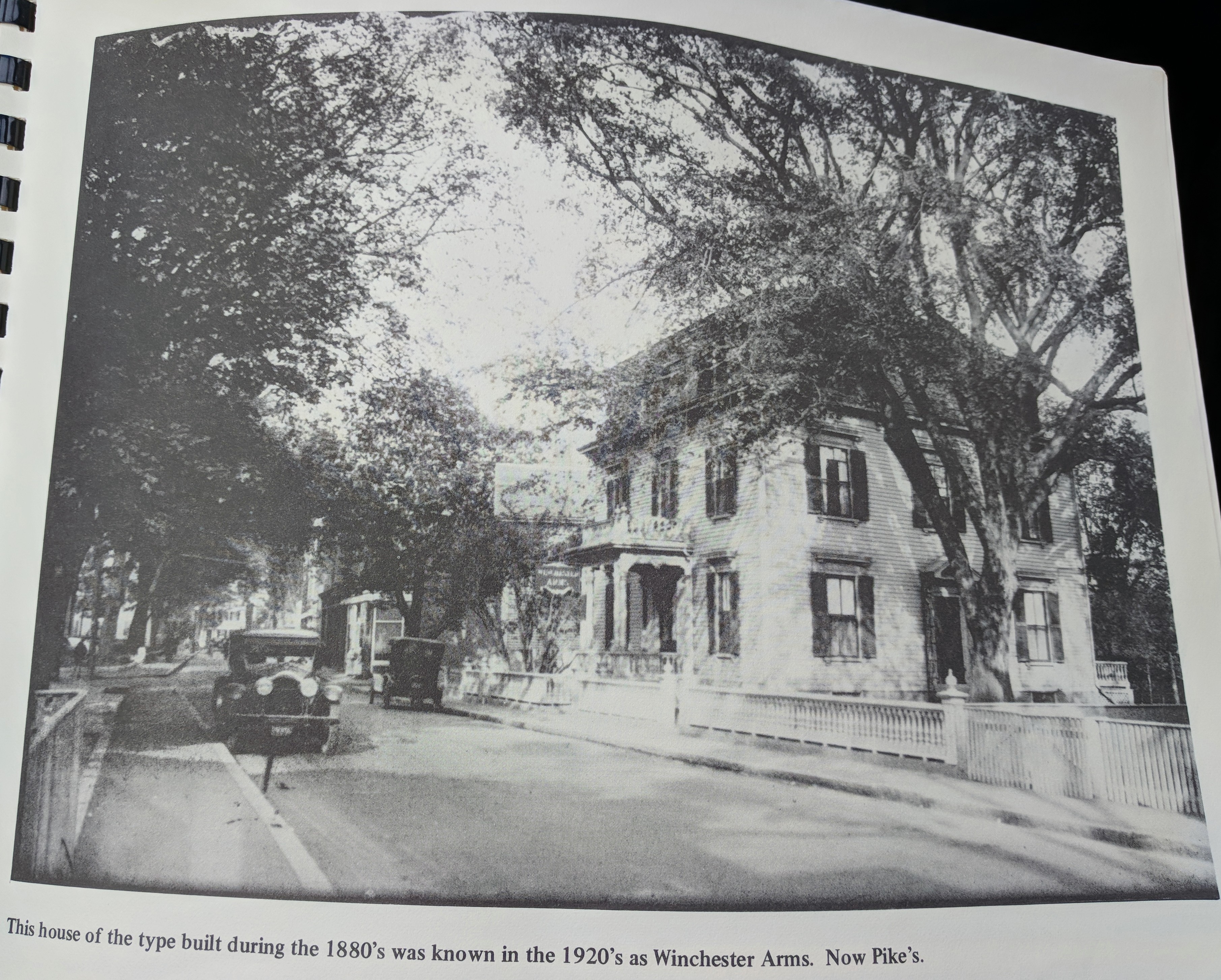
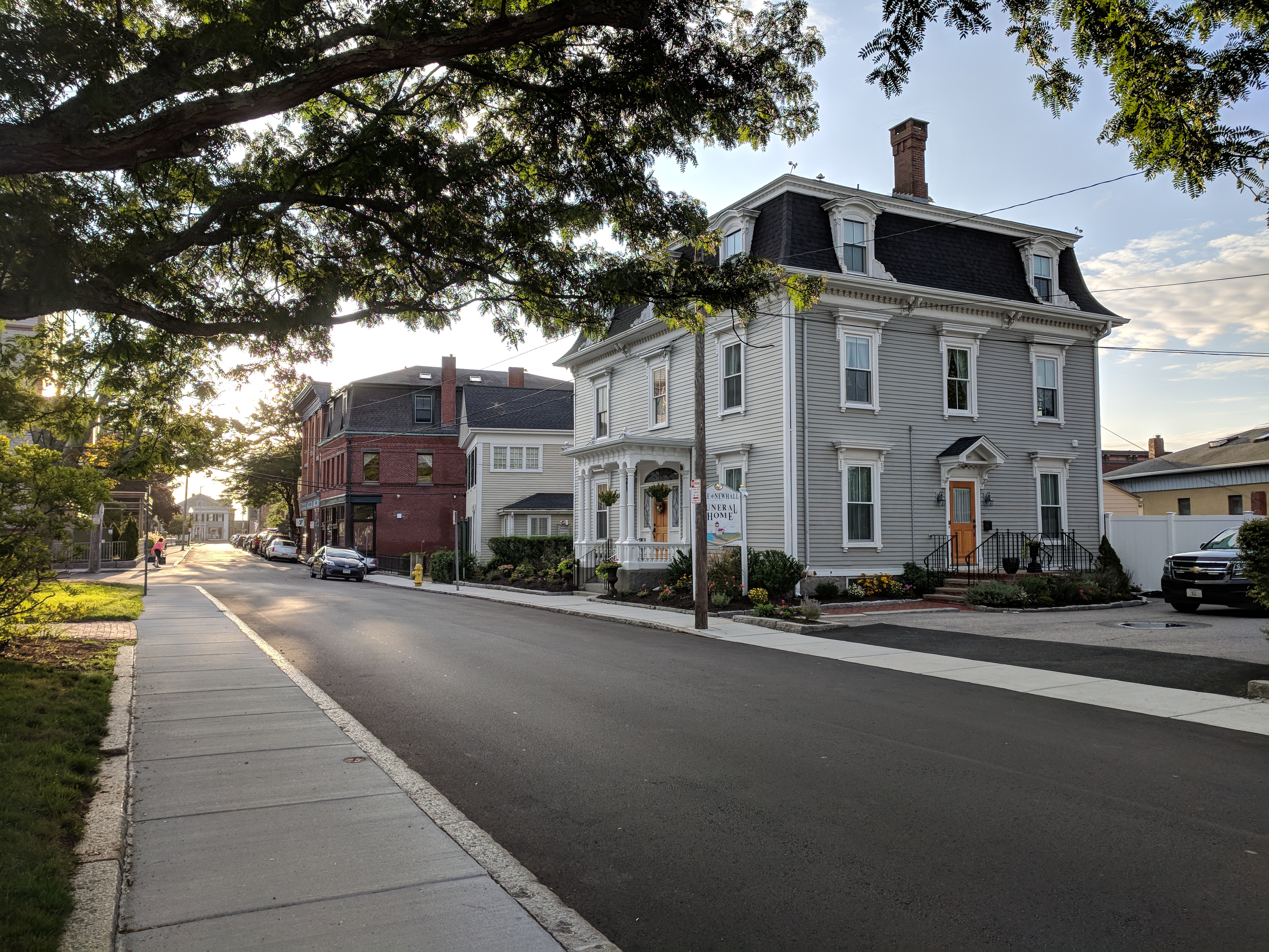
61 Middle Street Pike Newhall Funeral Home
Advertisement in 1902 Polk directory lists Pike business address on Washington Street prior to Middle Street relocation; the business was founded in 1900. 61 Middle formerly Winchester Inn
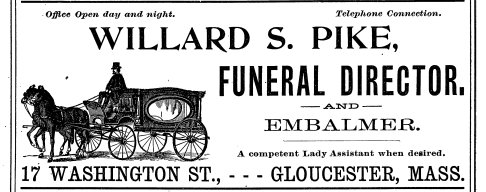


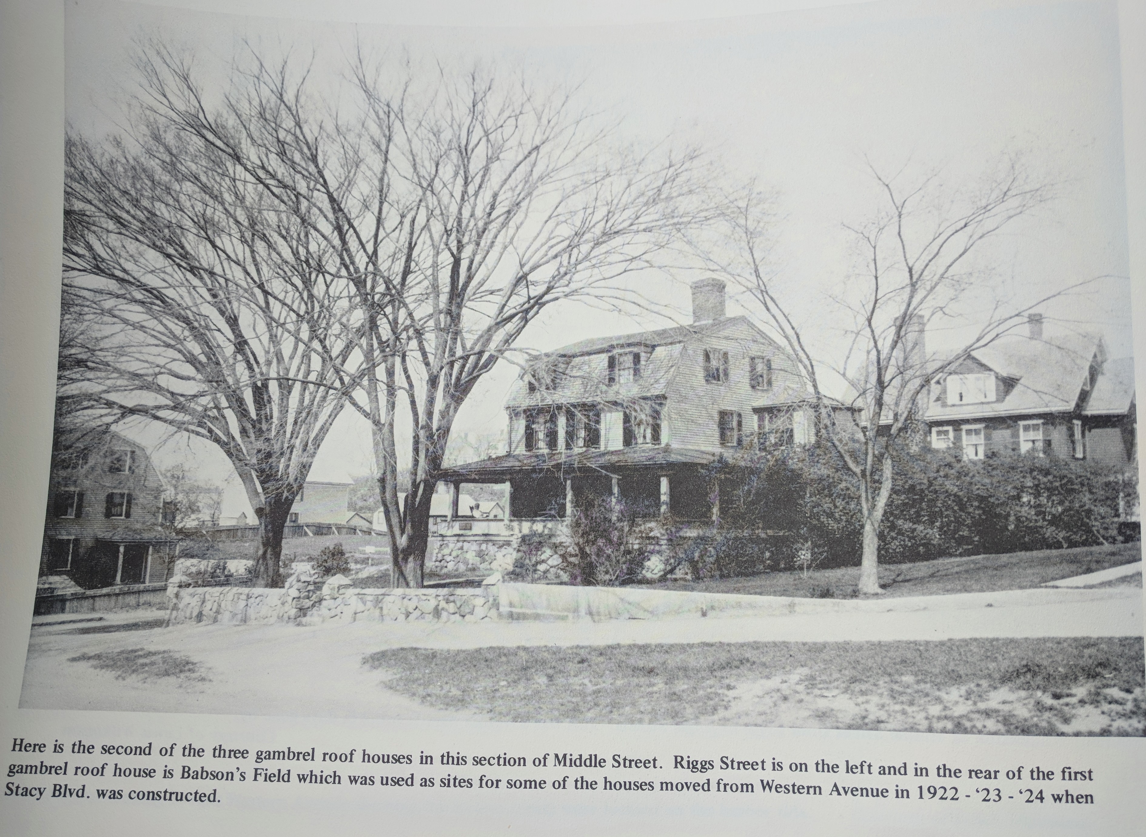
photo above: “Here is the second of the three gambrel roof houses in this section of Middle Street. Riggs Street is on the left and in the rear of the first gambrel roof house is Babson’s Field which was used as sites for some of the houses moved from Western Avenue in 1922-23′-’24 when Stacy Blvd. was constructed.” from History of Gloucester Vol. 3, published 1978, featuring photographs from James B. Benham collection and from Gaspar J. Lafata and Martin J. Horgan Jr.


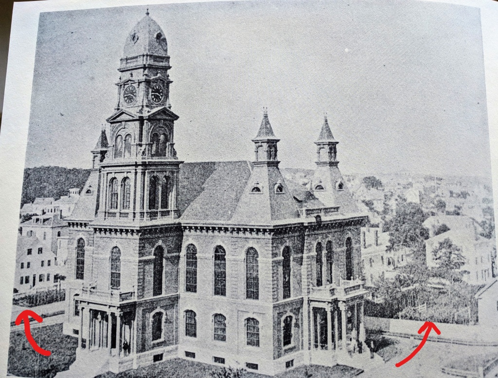


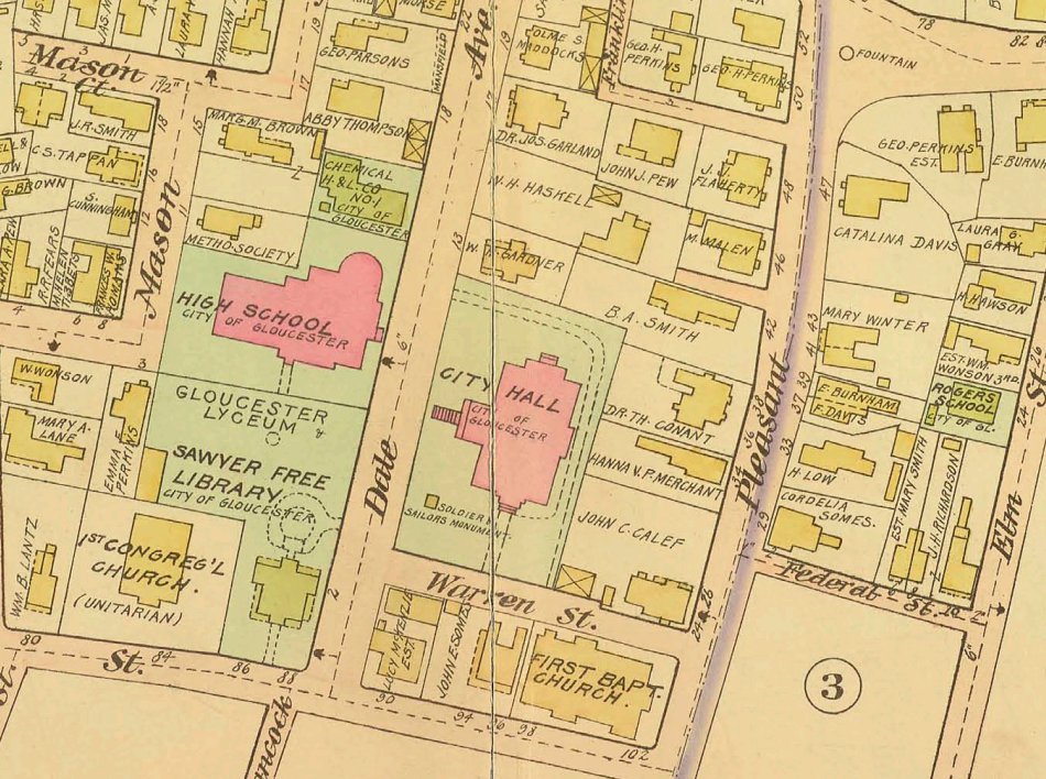
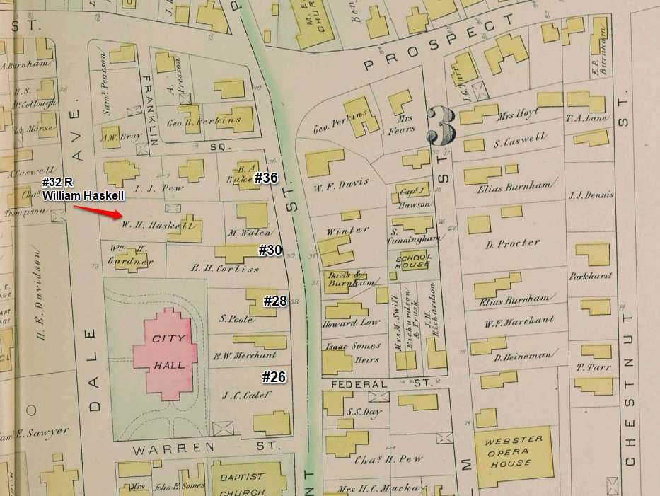
Annotated illustration: Note gardens on properties abutting City Hall. William Haskell’s lots spread between Dale and Pleasant (#44 now) streets and beyond where Carroll Steele is located now, numbered 32 Pleasant Street, rear when he lived there. On the 1884 Hopkins and 1899 Stadly maps the lot is identified where the new post office is now.
Another Haskell (Cpt. John Haskell) was associated with 34 Pleasant (former Moose Home*), and Melvin Haskell with 136 Main Street. *The house history trail for 34 Pleasant (THEN 26 Pleasant): Pearce-J. Haskell-Calef-Moose Lodge (razed 2011)-Cape Ann Museum parking lot. This area could be an African American history stop spotlighting both abolitionist and antiabolitionist connections.
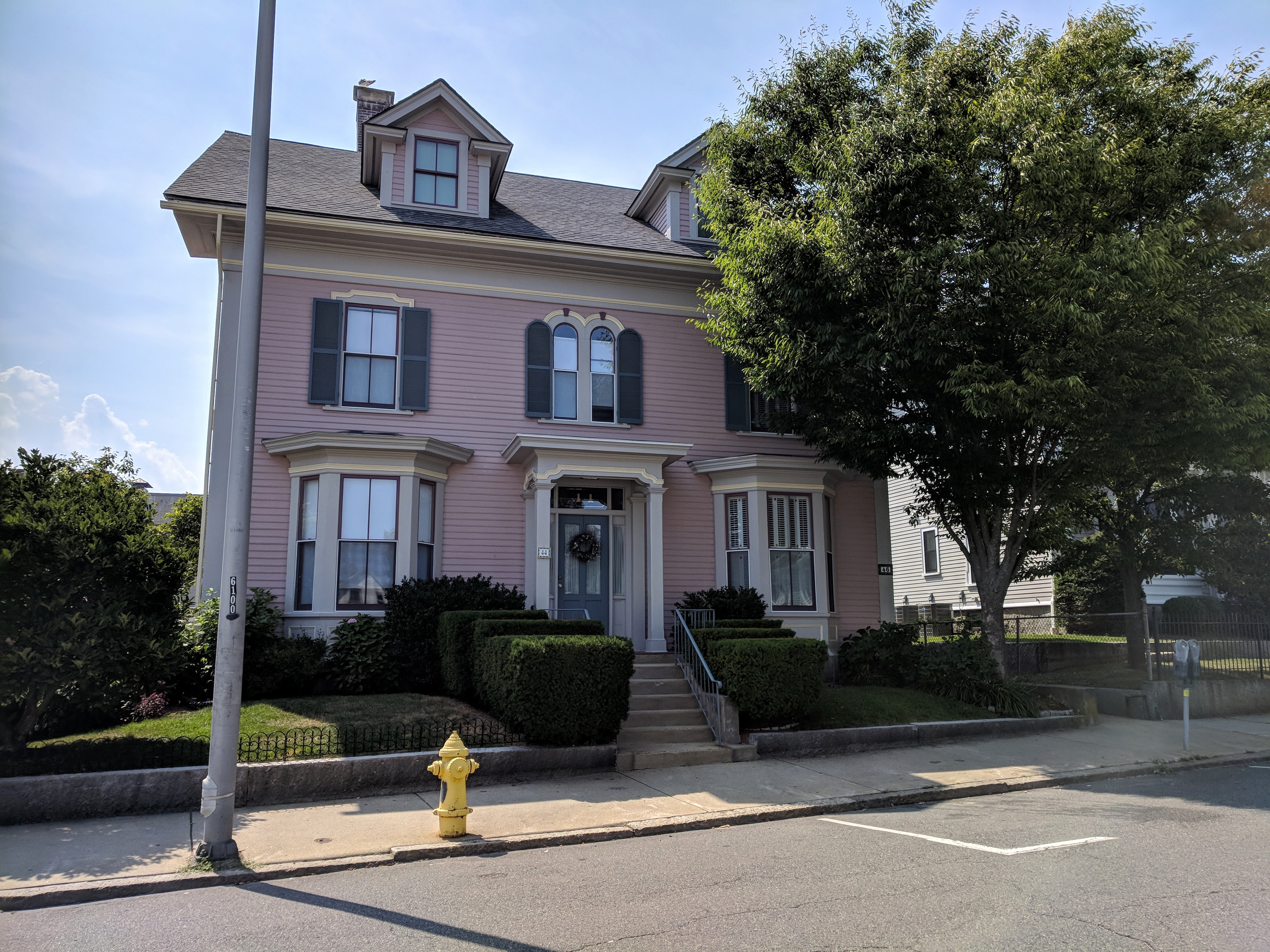
Street numbers were shifted. Behind #44 Pleasant Street now (below)
Dates: b.January 23, 1810 – d.August 26, 1902
Parents: Eli (b. 1776 Gloucester, MA) and Lydia (Woodbury Bray) Haskell
Brother: Epes
Grandfather: Elias Haskell
First Wife and two daughters: Sarah Ann Bray (1811-1836) “died September 12, 1836 leaving two daughters* now deceased, one of whom (Sarah*) married a Mr. (Thomas*) Symonds of Reading and the other (Judith*) married Edwin Bradley of Rockport and was the mother of Mr. Edwin Archer Bradley* of Gloucester, Mass.” E Archer Bradley was Captain Sylvanus Smith son-in-law. E Archer Bradley is listed in the 1913 Polk directory as Vice President of the Gloucester Mutual Fishing Insurance Co and Director Rocky Neck Marine Railway Company.
Second Wife and six children: Mary S. Smith (died August 15, 1889) Married July 19, 1838. They had six children: “William G. Haskell of Washington, DC, Col. Edward H. Haskell and Charles A Haskell of Newton, Frank A. Haskell of California and Mrs. Saddie, wife of Samuel W. Brown of this city. One son, Asaph S. Haskell, laid his life on the altar of his country at Morehead City, N.C., September 28, 1863, of yellow fever while a member of Co. C, Twenty-third Regiment, where he had gone awaiting transportation home, his death occurring on the date of the expiration of his term of enlistment.”
Raised: West Gloucester, learned the trade of shoemaker according to obituary
Gloucester 250th Anniversary: served as Vice President of 250th celebration committee
Residences: 44 Pleasant Street (was between Dale and Pleasant streets and beyond where Carroll Steele is located now) formerly address 32 Pleasant Street, rear– either may have evidence Undergound Railroad. Haskell’s lots spread between Dale and Pleasant.* Another Haskell (Cpt. John Haskell) was associated with 34 Pleasant (former Moose Home) and Melvin Haskell with 136 Main Street.
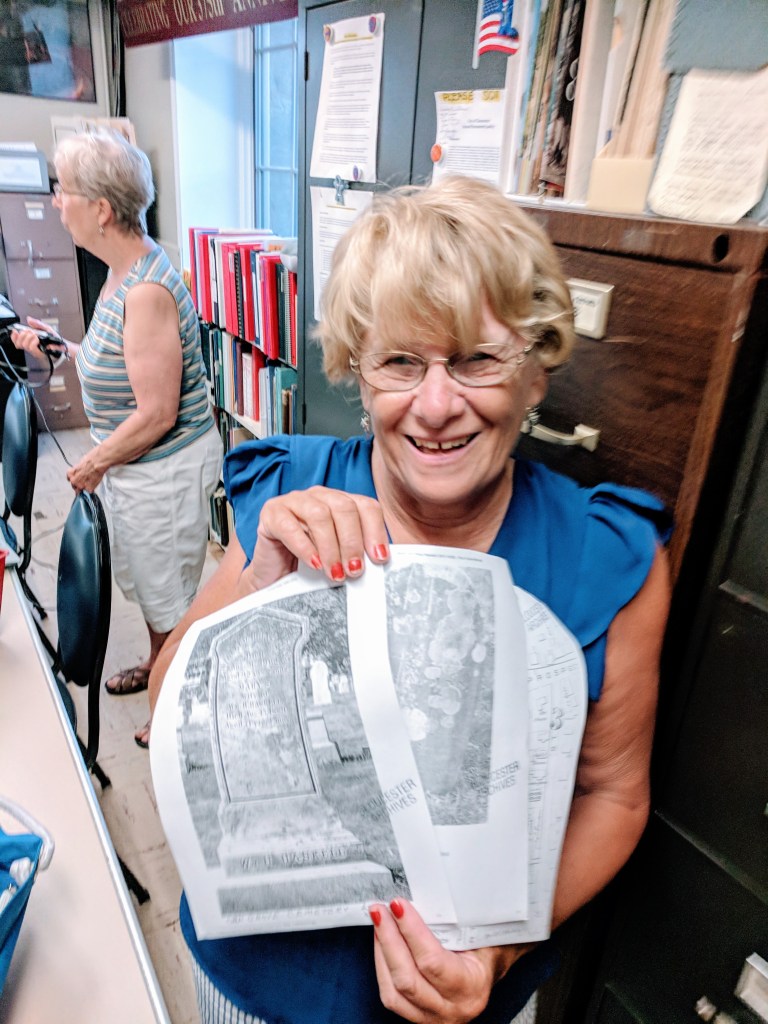
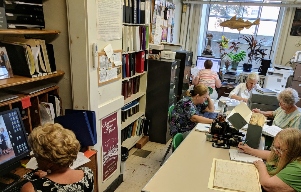
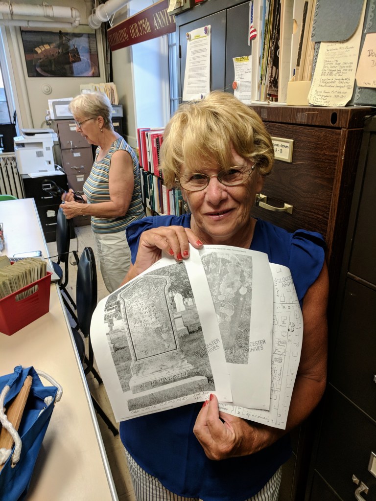
Biographical information I dug up and researched then confirmed at Gloucester Archives August 29th with a special thanks to Sandy and Sarah with Gloucester Achives. I wanted to confirm Haskell’s address and home, because streets and numbers change on maps over time, and because I knew Sandy could help best with tracking down cemetery information about Haskell’s first wife and the daughters’ names missing from records and I wanted to spotlight her dedicated efforts.
Haskell’s first wife is buried in West Gloucester- historic Sumner St. Cemetery. Haskell and his first wife had two daughters. Sarah Ann Frances, born September 28, 1832 in Gloucester, died young, in December 1853. She married Thomas S. Symonds July 1851. (Haskell and his second wife named one of their daughters, Sarah “Seddie” Symonds Haskell, after his first child.) The second daughter, Judith Goldsmith, born February 20, 1836, married Edwin Archer Bradley on November 8, 1854.
“OLDEST MALE RESIDENT DEAD: William H. Haskell Closes Life at Age of 92 years- An Original Abolitionist and Life-long Republican


