1979 time capsule – E. Raymond Abbott, former Cape Pond Ice owner and Gloucester philanthropist, on the history of Day’s pond, its waterlilies and a Rockport watershed

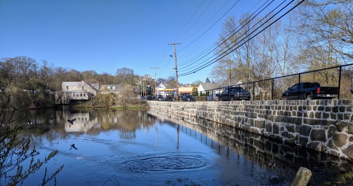
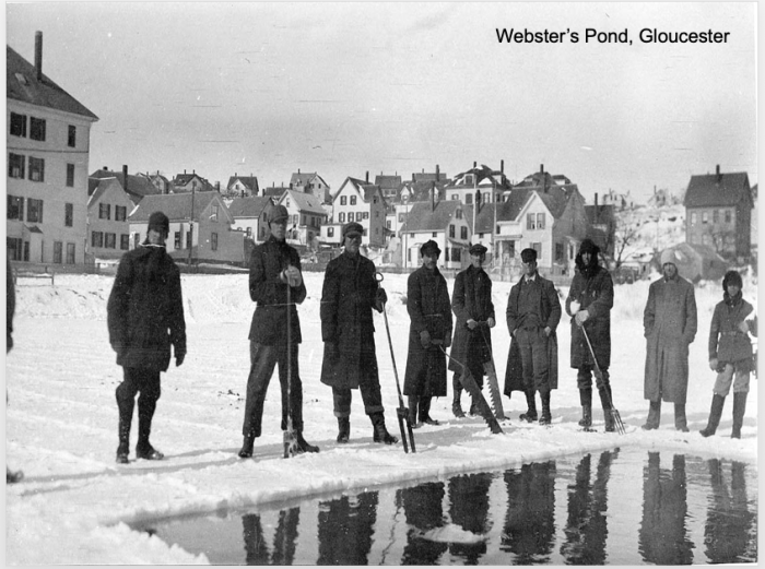
Next time you’re heading in the direction of Wolf Hill, Good Harbor Beach or Rockport thank E. Raymond Abbott when you pass Day’s Pond, a historic man made pond in Gloucester about 1 acre in size. In 1978 Abbott wrote about his family’s association with the pond:

stone wall repaired 2018 Day's Pond Gloucester MA_20190425_©c ryan (2)
2018 new engineered wall, railing (sidewalk pending) – read more about Gloucester DPW work here

“On reading a recent article in the Gloucester Daily Times (July 1979) which made reference to the ‘so-called’ upper Day’s Pond off Eastern Avenue it occurred to me that the people of Gloucester might be interested in a brief history of the pond.

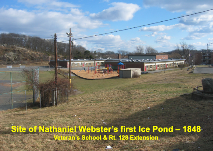
Years ago there were two Day brothers who owned a large tract of land which extended from the beaches and marshes all the way up to the old Rockport Road. This land, including the upper Day’s Pond, was later sold to a lawyer named Webster who lived in and owned a hotel on Pleasant Street. Later on the Webster property which also included land around Cape Pond in Rockport, came up for sale at a public auction. My father, James Abbott, bought it in June of 1905 and went into business which was later known as the Cape Pond Ice Company. In 1922, my father retired and I took over the ice business. 

I will always remember a young girl, Harriet Wonson, who lived just above the upper Day’s Pond, coming to me asking if she could beautify the pond by planting water lilies in and around it. Of course, I gave my consent.

In 1943, I decided to sell the Cape Pond Ice Company. However, before doing so, I gave the upper Day’s Pond to the city of Gloucester so that the children always have a place to skate in the winter, in the summertime provide a pond for fishing, as well as a beautiful subject for our local artists to paint. It was during this same period that I was able to acquire most of the land around Cape Pond and later gave my interest to the town of Rockport to be used as a water shed. 

It is my sincere hope and desire that the upper Day’s Pond will continue to provide as much enjoyment for the children of the future as it has in the past.

E. Raymond Abbott, Gloucester Daily Times Letter to the Editor, July 16, 1979

Twenty years later, Gloucester dredged Day’s Pond “as part of a watershed management plan to stabilize the pond’s ecosystem.” Massachusetts Department of Environmental Mangement awarded $2500 for the project in 1998. Marilyn Myett wrote a persuasive My View column about the pond’s vital impact in the neighborhood.

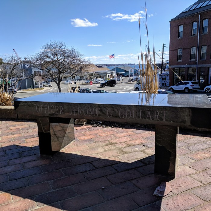
Cape Pond Ice was the subject of Mr. Goulart scavenger history challenge for 9th grade GHS students see results & historic photos here

GMG reader asks: Where have all the Lighthouse foghorns gone?

Annisquam Light_20190502_Gloucester MA_ © c ryan.jpg

photo caption : Annisquam lighthouse, Gloucester, Ma. photo copyright © C. Ryan, May 2, 2019

Question

“I’ve been living in Gloucester now since 2013 (and love it of course!). When we first moved to the city, we could hear the foghorns during inclement weather. However, about a year ago, I noticed that I no longer hear them. I loved this soothing sound on a gray day and am wondering what happened? Have the foghorns been turned off? Thanks!” –Patricia

Answer

Sort of. The foghorn sound has not changed but their frequency has dropped significantly because the systems are no longer automated in situ on light house grounds. Instead, foghorns are on demand now, manually kicked in by vessel operators. They are VHF automated to frequency 83 Alpha.  Five or more consecutive clicks sets the foghorn off for 30, 45 and 60 minutes depending upon the lighthouse.

The USCG in Gloucester explained that the USCGNortheast out of Boston tends the Cape Ann Lighthouses, albeit Thacher Island North Light which is private. The USCG  division responsible for all technology elements is called the “Aids to Navigation Team”, aka the USCGNortheast ANT unit.

Since 2010, slowly but surely the USCG has been replacing the automated VM-100 fog detector systems with  “Marine Radio Activated Sound Signal” or MRASS systems. VM-100 were problematic as parts were no longer fabricated and the systems were deemed less reliable and obsolete. Boaters rely on common knowledge. Many access USCG light list, GPS on their cellphones, chartplotters, and radar. When the weather hedges to the odds of even one boater being confused by fog, evidence suggests crowdsourcing engages the signal. Expect frequency to increase in summer when more boats are on the water.

The change was not without controversy. See the history of transition in Maine. Locally, a 2013 Gloucester Daily Times editorial expressed support of the Rockport Harbormasters’ opposition. Because of broad push back, the roll out was slowed down for better outreach and acceptance.  The “drop date” requiring all foghorns nationwide to be in compliance was May 1, 2019.

“The upkeep of the MRASS foghorns is so much easier,” explains Petty Officer ONeal of the USCG ANT in Boston. “All the foghorns from Plymouth to Newburyport have been converted. Eastern Point was switched over yesterday.”

I sympathize with this lament for the foghorn. And I appreciate the challenge of maintenance and adaptation. Understandably safety, navigation, cost and care were essential topics of discussion, less so audible texture, mood, sense of place & culture. (Never mind the challenge of mastering dead reckoning when vision fails.) The allure of the sound from shores, often traveling great distance, is in the ear of the listener. Beguiling. Haunting. Soothing. Despondent. Scary. Annoying [see bestselling author Elizabeth Stuart Phelps LTE complaints ca.1880 about the whistling buoy off Mother Ann and that’s no foghorn] What do you think, GMG readers, and vessel experts?

Like train engineers blowing the whistle obliging ogling toddlers, maybe a few boaters will queue the sound in dreary weather for pining landlubbers. Technology changes that’s certain. Perhaps the poetic qualities will be baked into future foghorn design despite obsolescence.

The MRASS system is robust and here now. Thanks to USCG Gloucester and Petty Officer ONeal USCGNortheast ANT unit Boston for confirming details and to GMG reader Patricia for a great inquiry!

RESULTS Week 6 1851 | #greatteacher Mr. Goulart’s local history hunt concludes #GloucesterMA #TBT

GHS_20190318_ c ryan.jpg

Gloucester, Mass.  A great teacher at Gloucester High School, Shaun Goulart, creates a local history scavenger hunt/trivia game for his 9th grade students that takes place weekly for 6 weeks.

ANSWERS TO SHAUN GOULART’S LOCAL HISTORY SCAVENGER HUNT TRIVIA WEEK SIX. THIS CHALLENGE IS THE FINAL WEEK IN THE SERIES. GO BACK HERE IF YOU WANT TO SEE WEEK 6 QUESTIONS ONLY.

The challenge Week 6 was to locate the historic map on Cape Ann Museum’s Fitz Henry Lane on Line and study it closely to comb through location prompts. This is a great family activity for all ages. It’s a bit eye spy or Where’s Waldo mixed with atlas map fun. The students were tasked with photographing the same sites as they appear today and creating a labeled presentation.

Visit CAPE ANN MUSEUM FITZ HENRY LANE ON LINE resource and scroll down to the correct map here

Map of the Towns of Gloucester and Rockport (detail of Harbor Village)
Henry Francis Walling (F. Walling)
1851
44 x 34 in.
Henry Francis Walling, Map of the Towns of Gloucester and Rockport, Essex Co. Massachusetts. Philadelphia, A. Kollner, 1851
Cape Ann Museum Library & Archive
“Map of the Towns of Gloucester and Rockport, Massachusetts. H.F. Walling, Civil Engineer. John Hanson, Publisher. 1851. Population of Gloucester in 1850 7,805. Population of Rockport in 1850 3,213.”
Map detail = segment of Harbor Village portion of map showing Lane-Winter property on Duncan’s Point.

  Question – find on 1851 historic map ANSWER- NOW (2019)
1 Duncan’s Point Maritime Gloucester / Railways (former FG Low’s & Eli F. Stacy’s whf)
2 Five Pound Island State Fish Pier
3 Front Street (present sign must be in picture) Main and Short
4 Middle Street (present sign must be in picture) Middle Street
5 High Street School Street and Proctor
6 Fort Defiance The Fort
7 Vincent’s Cove West End Main Street and Rogers section all fill / Gorton’s, Americold, etc
8 Town House Legion
9 Gloucester House Brick building corner of Washington and Main (Puritan House)
10 Two cemeteries 1)cemetery next to Amvets on Prospect 2)St. Ann’s
11 Hospital up  Granite Street veers right to Blyman
12 Town Landing Same (St. Peter’s)
13 Two bowling alleys 1)on Stacy Boulevard (see Cordage manufactury below)

2) on the Fort

14 3 schools study the map!
1)by Univ Church and Eng H& School on Church off Middle on old map
2)looks like where Central Grammar is
3)Prospect and School where apartments are now
4)corner Washington and Gould Ct.
15 Train station Roughly train platform now
16 Engine house Beyond train platform- roughly where Stop & Shop is on RR Ave
17 Canal Street Stacy Boulevard (Tavern side)
18 Cordage Manufacturing Ditto
19 Beach Street Commercial Street (behind Beauport Hotel back to water)


Fort Defiance the fort

Prior Posts Continue reading “RESULTS Week 6 1851 | #greatteacher Mr. Goulart’s local history hunt concludes #GloucesterMA #TBT”

RESULTS Week 5 Police | #greatteacher Mr. Goulart’s local history hunt #GloucesterMA #TBT

Gloucester, Mass.  A great teacher at Gloucester High School, Shaun Goulart, creates a local history scavenger hunt/trivia game for his 9th grade students that takes place weekly for 6 weeks. We’re taking the challenge paced one week after the students.

ANSWERS TO SHAUN GOULART’S LOCAL HISTORY SCAVENGER HUNT TRIVIA WEEK FIVE

1)What year was there an ordinance to establish a Police department in Gloucester? ANSWER: 1873 (according to the Gloucester Time Line archives book and the great Gloucester police website here : “In 1799, Isaac Elwell was appointed Inspector of Police. This was a term first used in Boston 14 years earlier to describe the men appointed to keep track of the night watchmen who patrolled the city after dark watching for fires. Constables assisted Elwell and other men who followed him as Inspector of Police until about 1847 when a petition was received by the Selectmen asking for some additional policemen to assist the Inspector of Police. Around 1850 the first night police were used. Only a few of the policemen were paid as the rest either served without compensation or were only paid for working during special occasions. In 1873, a city ordinance establishing a police department was put into effect with nine officers under the leadership of City Marshal William Cronin.”)

Gloucester Massachusetts archives timeline book_20190411_city hall_© Ray ed Sarah Dunlop © photo catherine ryan
Gloucester Massachusetts Historical Time-line 1000-1999 Mary Ray, ed. Sarah Dunlap Gloucester City Archives published in 2002. You can purchase this book from the Archives.

2)The original building used as a jail prior to 1889 was located on Rogers Block, take a picture of this area present day with a member in it. ANSWER: Main Street (harbor side) from Duncan to Porter

1891 walker map.jpg
Rogers block = Main Street (from Porter to Duncan) detail from 1891 Walker map


3)Where was the first Gloucester police station built in 1889, take a picture with a member in it at the location. ANSWER: corner of Duncan and Roger


4)Veterans of what war had a hall for them located on the third floor of the building? ANSWER: Spanish American in the police station that was built in 1899. City Hall Read about bronze veteran tribute plaques (including Spanish American) at City Hall here

old police station.png
from Mr. Goulart Old Police station built in 1899 at the corner of Duncan and Roger (2019 = police parking lot)

1971/1973 newspaper clipping from Sawyer Free

June 1971August 20 1974 wrecking ball to police station

5)What year was the present day police station erected? Take a picture of it with a member in it. ANSWER: 1973

IMG_20190401_151154.jpg

6)Go to the exterior of the police station and take a picture with an object that would be personal to Mr. Goulart (keyword: Goulart) ANSWER: Officer Jerome G. Goulart memorial bench

Officer Jerome G. Goulart memorial bench_Gloucester Ma_police station_20190401_© c ryan.jpg


7)Take a picture with a Gloucester Police officer in uniform. Answ. How cool are these officer baseball cards!


“Kops-n-Kids” is a Gloucester Police Department (Official) initiative where officers visit Gloucester Schools to interact with students during recess & gym class

8)Ask the cop: What is the code word for “lunch break” over the radio. Submit the answer. ANSWER: 1093

9)For a brief time the “Old Stone Jug” served as a jail, take a picture in front of it with a member in it. What is this building known as? ANSWER: Fitz Henry Lane former house and studio 

old stone jug_20190401_145605.jpg

10) Where does the term cop come from? ANSWER: not definitive though according to snopes meaning “nab” closest: “Instead, the police-specific use of “cop” made its way into the English language in far more languid fashion. “Cop” has long existed as a verb meaning “to take or seize,” but it didn’t begin to make the linguistic shifts necessary to turn it into a casual term for “police officer” until the mid-19th century. The first example of ‘cop’ taking the meaning “to arrest” appeared in print around 1844, and the word then swiftly moved from being solely a verb for “take into police custody” to also encompassing a noun referring to the one doing the detaining. By 1846, policemen were being described as “coppers,” the ‘-er’ ending having been appended to the “arrest” form of the verb, and by 1859 “coppers” were also being called “cops,” the latter word a shortening of the former.”- snopes


Prior Posts Continue reading “RESULTS Week 5 Police | #greatteacher Mr. Goulart’s local history hunt #GloucesterMA #TBT”

RESULTS Week 4 INVENTORS | #greatteacher Mr. Goulart’s local history hunt #GloucesterMA #TBT

Gloucester, Mass.  Great teacher at Gloucester High School, Shaun Goulart, creates a local history scavenger hunt trivia game for his 9th grade students that takes place weekly for 6 weeks. We’re taking the challenge paced one week after the students.

ANSWERS TO SHAUN GOULART’S LOCAL HISTORY TRIVIA WEEK FOUR

How did you do? Week two delved into Gloucester’s famous inventors. Stop here if you prefer to go back to see Week 4 questions only

Mr. Goulart’s Local History Trivia Scavenger Hunt Week 4 Inventors

1.John Hays Hammond Jr. “Jack”

  • Go to the location of his home and take a picture with a member in it.

  • What did he invent?

Answer: “Over the course of his professional career, he was awarded over 800 foreign and domestic patents resulting from over 400 of his inventions.  Many of these began in radio control before extending to electronics, naval weapons, national defense, as well as various consumer products.” – Hammond Castle

“In connection with his radio researches Jack obtained most important patents for receiving and broadcasting and these he sold to RCA…” John Hays Hammond, Sr

hammond 3109


Hammond first radio boat off Gloucester_The boat is run from the shore as no one is aboard_photograph Boston Public Lib

Hammond Castle – I hope that one day the Trustees and Historic New England add this as a shared property among their preservation jewels, along with the Natalie Hammond property and much of the parents’ estate, Lookout Hill, with some portion of admission for the City. At one point Hammond Castle was one of the top attractions in Massachusetts.


2.Clarence Birdseye

  • Go to the location where his company was and take a picture with a member in it.

  • What did he invent?

Answer: flash freezing

Beauport Hotel Gloucester Ma_former site Birdseye_25 March 2019_photo copyright Catherine Ryan
photo: Beauport Hotel, March 2019 ©catherine ryan 

3.Augustus H. Wonson

  • Go to the location of his grave and take a picture with a member in it.

Answer: Mt. Pleasant cemetery

  • What did he invent?

Answer: Augustus S Wonson invented antifouling copper paint to protect boats. Tarr & Wonson’s was established in 1863.  The former factory and harbor icon is now Ocean Alliance.

Mt Pleasant grave_20190325_© c ryan

Paint Factory Past/Present

574209pv

Paint Factory Ocean Alliance_20180928_ Goetemann artist Deborah Redwood Whale in process public art_Glouc MA©catherine ryan

Paint Factory Ocean Alliance_2018 09 28_ Goetemann artist Deborah Redwood public art – whale’s tail in process_Gloucester, MA © catherine ryan

4.William Nelson Le Page

  • Go to the location where his company was after it moved from Rockport and take a picture with a member in it.

  • What did he invent? 

Answer: Le Page’s glue from fish waste (established 1876)

  • Go to the location of Le Page’s company co-founder Ruben Brooks’ manor and take a picture with a member in it.

Answer: Castle Manor Inn

lepage now_20190325_Gloucester MA © c ryan


Castle Manor Inn_20190325_© catherine ryan


Prior Posts Continue reading “RESULTS Week 4 INVENTORS | #greatteacher Mr. Goulart’s local history hunt #GloucesterMA #TBT”

RESULTS WEEK 3 #Gloucester Ma FIRSTS| try Mr. Goulart’s local history hunt Throwback Thursday

Gloucester High School_20190318_photo © catherine ryan.jpg

Gloucester, Mass.- Great teacher at Gloucester High School, Shaun Goulart, creates a local history scavenger hunt trivia game for his 9th grade students that takes place weekly for 6 weeks. We’re taking the challenge one week after the students. Good luck!

ANSWERS TO SHAUN GOULART’S LOCAL HISTORY TRIVIA WEEK THREE

How did you do? Week three was all about some famous Gloucester FIRSTS and there were many locations.   Stop here if you prefer to go back to see Week 3 questions only.

1)The location of Gloucester’s first “Four Year High School” 

Principal Albert Bacheler CENTRAL GRAMMAR

Central Grammar first four year high school Principal Albert Bacheler_20180505_photo copyright © catherine ryan.jpg

2)The location of Gloucester’s first Brick Building?

PURITAN HOUSE built in 1810 by Col. James Tappan* is a historic house at 3 Washington Street and 2 Main Street. Also known as: Tappan’s Hotel, Gloucester Hotel (“Tappan’s Folly”), Atlantic House, Mason House, Community House, Capt Bills (1960s-70s), Puritan House & Pub (1977), Blackburn Tavern (1978-00s) *Tappan was taught by Daniel Webster

Excerpt from prior GMG post (read it here) about scenic tours by bike 1885: “And now let’s take our wheel for a short run along our harbor road to East Gloucester, and note the many points of interest on the way. The start is made at the Gloucester Hotel–the headquarters of all visiting wheelmen in the city–at the corner of Main and Washington streets; from thence the journey takes us over the rather uneven surface of Main street, going directly toward the east. In a few minutes we pass the Post Office on the left, and soon leave the noisy business portion of the street behind us, then, e’re we are aware of it, we reach and quickly climb the slight eminence known as Union Hill…” This brick building at Main and Washington now features Tonno Restaurant. Notice the chimneys and same stairs as when it was the Gloucester Hotel. The Blackburn Tavern sign was just marketing; this building has no connection. Blackburn’s Tavern is now Halibut Point restaurant at the other end of Main Street.


3)The first schoolmaster and town clerk’s house. (private property do not trespass)

RIGG’S HOUSE” 27 Vine Street (Annisquam) Thomas Riggs House purchased in 1661

oldest house on Cape Ann, Gloucester, MA

Oldest House on Cape Ann.jpg

Fredrik D. Bodin.jpg


4)A list of the first recorded Gloucester fishermen lost at sea. (Hint: 1716)

Look under the year on cenotaph surrounding Man At Wheel

annual fishermans memorial service_Mayor Romeo Theken_20160827_fisherman at wheel cenotaph gloucester© catherine ryan.jpg
Mayor Romeo Theken, annual Fisherman’s Memorial Service, 2016

5)The location of the first carillon built in America.

Our Lady of Good Voyage – read more http://gloucester.harborwalk.org/story-posts/sp-20/

Subshop with a view- through Destinos window

view from destinos subss 2017

6)The location of Gloucester’s oldest surviving burial ground for the First Parish.

1644! – 103 Centennial Drive – top of Centennial Drive near the train bridge


7)The location of Gloucester’s first town hall.

Continue reading “RESULTS WEEK 3 #Gloucester Ma FIRSTS| try Mr. Goulart’s local history hunt Throwback Thursday”

RESULTS WEEK 2 Defending #GloucesterMA | try Mr. Goulart’s local history hunt Throwback Thursday #TBT

Gloucester High School_20190318_photo © catherine ryan.jpg
Gloucester, Mass.- Great teacher at Gloucester High School, Shaun Goulart, creates a local history scavenger hunt trivia game for his 9th grade students that takes place weekly for 6 weeks. We’re taking the challenge one week after the students. Good luck!

ANSWERS TO SHAUN GOULART’S LOCAL HISTORY TRIVIA WEEK TWO

How did you do? Week two delved into scenes of historic battles. I’ve added some background. Stop here if you prefer to go back to see Week 2 questions only from 3/17/19 

WEEK 2: DEFENDING GLOUCESTER Location #1

  • Who was the first governor of Massachusetts Bay Colony? ANSWER –  ROGER CONANT
    • Go to the location of the fort named after him and take a picture with a member in it. *Stage Fort Park “Fisherman’s Field”

*“In 1623, 14 English fishermen set up the first European colony on Cape Ann here in what was then Fisherman’s Field and is now Stage Fort Park. These ramparts overlook the harbor, first built during the Revolutionary War, renewed for the War of 1812, the Civil War and the Spanish American War. Alas, those first settlers, sent across the ocean by the Dorchester Company, were unable to live off the sea and these rock-bound fields. They moved a few miles south to what is now Salem in 1626. Then, within a decade, there were enough permanent settlers on Cape Ann to incorporate the town of Gloucester. The first meetinghouse was built on the Town Green in 1642 near what is now the Grant Circle rotary of Route 128. The City set this land aside as a public park in 1898 and its Tablet Rock was dedicated by Henry Cabot Lodge in 1907.  James R. Pringle was designated to write the inscription for the bronze plaque. The execution of the design was by Eric Pape. “The nautical scheme of decorative framework and embellishment was the composite suggestion” of various committees dating as far back as the 1880s.” *see Gloucester HarborWalk Stage Fort Park marker #42  photo on marker ©Sharon Lowe. See also Stage Fort Park then/now photos in prior GMG post

Bronze tribute plaques embedded in Tablet Rock at Stage Fort Park detail the site’s history and were commissioned and unveiled at different times. The monumental and stunning Founders plaque from 1907 on Tablet Rock itself is in fantastic condition. Two DAR plaques were inlaid on the glacial outcroppings past half moon beach on the way to the cannons. The Fisherman’s Field (ca.1930) is so worn it’s nearly indecipherable, though that’s part of its charm. The plaque compels close inspection, lingering and discovery. It’s a fun family activity for anyone who likes a challenge. For those who want help reading the content, I transcribed it back in 2010. Scroll down below the “read more” break in this post to open.


  • During which war did it receive this name? ANSWER – FORT CONANT during the Civil War 
detail-battery-k
When you zoom in on this 1901 photograph, you can see the big ‘Battery K’-  for the Spanish American War (Camp Hobson) Fort conant during Civil War


Location #2

location 2 courtesy photos


  • Take a picture at Fort Point with the former location of the Coast Guard Aviation Station behind you (must be visible in the picture) ANSWER – TEN POUND ISLAND
  • What was the fort called on Fort Point? ANSWER – FORT DEFIANCE Fort Point Hill, Fort Lillie (Lily)
  • Name a war it was utilized in. ANSWER – Efforts to fortify as early as 1703 (see Pringle) ATTACK OF CAPTAIN LINDSAY (OR LINZEE) 1775 –population about 5000 –REVOLUTIONARY WAR, WAR OF 1812, CIVIL WAR

“In 1743, what is known as the old fort on Commercial Street, now encroached upon and surrounded by buildings, was completed. On this point, well selected strategically, is a hill which effectually commands the inner harbor. In 1742 and 1742, the General Court appropriated 527 pounds to defray the cost of fortification. Breastworks were thrown up and eight 12-pounders placed in position in the fort. The immediate cause of its erection was the fear of French incursions, but these fears were never realized. An effort had been made as early as 1703 to fortify the place, but the petition of the selectmen to the General Court for an appropriation for the purpose was refused. The petition shows that he harbor, even at that early date was extensively frequent for shelter, and was “very seldom free from vessels.”

“In order to be better prepared for future assaults breastworks were thrown up at Stage Fort, the Cut, Duncan’s Point and Fort Point. This, however was the last attack by sea or land that the people experienced.”

Location #3

  • From Fort Point go to the location of the seven-gun earthwork battery and barracks in ramparts field. Take a picture with the old towers in the background (do not go on private property) ANSWER –  EASTERN POINT FORT by eminent domain, Ramparts Field Road Fort Hill 
  • Name a war it was utilized in  ANSWER –  CIVIL WAR

“Immediate action was taken toward the erection of fortifications. Land at Eastern Point, belonging to Thomas Niles was acquired by the government, and earthwork fort erected and manned…”

Screenshot

  • Screenshot Google Earth with all three above locations in it and circle them. Submit the image.

map.jpg

Continue reading “RESULTS WEEK 2 Defending #GloucesterMA | try Mr. Goulart’s local history hunt Throwback Thursday #TBT”

RESULTS WEEK 1 | try Mr. Goulart’s local history hunt #GloucesterMA Throwback Thursday

GHS_20180423_©catherine ryan
Gloucester, Mass.- Great teacher at Gloucester High School, Shaun Goulart, creates a local history scavenger hunt trivia game for his 9th grade students that takes place weekly for 6 weeks. We’re taking the challenge one week after the students. Good luck!

ANSWERS TO SHAUN GOULART’S LOCAL HISTORY TRIVIA WEEK ONE


How did you do? Week one delved into the history of Cape Pond Ice. More than one player “had to call a friend”, Scott Memhard, owner of Cape Pond Ice and City Councilor. He kindly shared supplemental archival material included in this post. Stop here if you prefer to go back to see questions only from 3/10/19 Week One trivia questions

Continue to scroll for the answers.


courtesy photo from Scott Memhard Cape Pond Ice Gloucester Mass (3)

1)In 1848 a blacksmith named Nathaniel R. Webster started a company by damming a local brook. What did the brook become known as?  ANSWER. VETERANS ELEMENTARY SCHOOL CAMPUS

2)What did Webster’s company become known as? ANSWER. CAPE POND ICE

3)Take a picture at the present day location of the company 

20160718_© catherine ryan.jpg

4)Take a picture of the street named after him with a member in it. ANSWER. WEBSTER STREET

5)What is in place of the brook today?  MATTOS FIELD-  ABOVE = FRAT CLUB AND BELOW EVENTUALLY LEADS INTO LITTLE RIVER AT GOOD HARBOR BEACH

WATER PATH.jpg

6)Take a picture at the location of the old dam with a member in front. ANSWER. THE SCHOOL


PART II

7)A competitor to Webster named Francis W. Homans in 1876 created a 32 acre man-made lake. What is the lake known as? ANSWER. FERNWOOD LAKE


8)Submit a screenshot of a map of the lake (Google Maps or Google Earth)

Fernwood lake.jpg

9)What year did the two companies merge? ANSWER. 1908

Courtesy photos below from Scott Memhard, Cape Pond Ice, Cape Ann Museum


Courtesy photo from David Collins-

“My grandfather, Millard Collins, Sr., worked for one of the ice houses for a while. He died in 1918 at age 29 in the Spanish Flu pandemic. At that time he was working for LePages’s and had taken a leave of absence to care for his brother, Jacob, who had contracted the flu first. Jacob died October 17, 1918, and my grandfather died October 28, 1918…”

“I’m enclosing a picture of my grandfather and his horse-drawn ice wagon. You can see the word “ICE” faintly written on the inside back of the wagon. The youngster atop the horse is my father, who was born in July,1912, so I date the picture to about 1913 or so.”

courtesy photo from david collins.jpg

Prior Posts

3/10/19 Week One trivia questions