11:30AM. Tide surge – area coastal flooding in typical spots.
Cars lightly backed up heading on to Nautilus for Atlantic/back shore drive
p.s. If you’re heading to CVS and Stop & Sho,p use the Charlie’s entrance.


My View of Life on the Dock
11:30AM. Tide surge – area coastal flooding in typical spots.
Cars lightly backed up heading on to Nautilus for Atlantic/back shore drive
p.s. If you’re heading to CVS and Stop & Sho,p use the Charlie’s entrance.
Charlotte and I caught a glimpse of a wonderfully energetic Red Fox this morning. It was all over the field vigorously digging in the ground for mice and voles, running in a sort of leaping and prancing manner, rolling around in the grass, and then just before heading into the wooded edge, it took a long pause to poop.
I at first did not understand what was going on with its fur. You can see a funny looking fluff of white remains on the tail and parts of it coat are still thick with winter fur whereas the fur was very short in other areas. I didn’t think it was mange because he appeared full of vim and vigor.
Both Red and Gray Fox begin to moult (or shed) their fur in spring. The shorter and cooler summer coat grows in while the long shaggy coat falls out, still clinging in some areas. Perhaps the Fox was rolling in the grass to help rid itself of the old coat.
Rolling in the grass
Watching this beautiful creature hunting at day’s end, it was fascinating to see the Marsh Hawk hovering, suspended mid-air for moments at a time. With razor sharp focus it’s gaze did not swerve. He swooped down toward the tall grass and I lost sight of him after a brief, second long glance from the ground. I hope he caught his dinner!
I don’t suggest that the treacherous bridge needs to be “preserved” or want to impede progress. However, I believe there is still time to repeat my pleas (since 2012). Great design impacts future investment. Is there a small way that the design can tip its hat to Edward Hopper, Gloucester, and New England for this landmark and beacon for Cape Ann, this cherished vista across the Great Marsh?
See GMG POST September 9, 2017 for design nod aesthetic suggestions (rather than structural) The budget is good! “Does the MBTA new design for the Annisquam River Bridge look like a prison tower to you?”
Here’s how the bridge and new condos looked November 9, 2018 (double click to enlarge photos from the wordpress mosaic format)
the design plans illustrated are the same as published previously
Beautiful build by Gloucester DPW to Good Harbor Beach is seeing steady use. The new pedestrian bridge spanning the marsh little river makes it easy to linger over a sweeping November vista to Good Harbor Beach and back.
Prior posts on Good Morning Gloucester about the marsh walkway under construction.
October 6, 2018 snazzy new guardrails
September 12, 2018 construction begins
Check out the trailer for Nubar Alexanian’s forthcoming tremendous documentary Recipe for Disaster: Green Crabs in the Great Marsh. A first-time screening will be held at the Cape Ann Cinema on Tuesday, September 18th at 7:30pm sharp.
The trailer may be viewed here.
A new mini marsh promenade is underway along Thatcher Road from Gloucester’s Good Harbor Beach entrance all the way around to the foot bridge. Walkers will have safe access via sidewalks and a natural path.
Gloucester has been planning for an opportunity to extend safer pedestrian access along Thatcher Road for years. When National Grid scheduled replacing antiquated gas lines along the busiest and scenic stretch, Gloucester Public Works was ready to seize the opportunity with collaborative solutions sensitive to conservation. Sidewalk upgrades were built out at both ends and paused until National Grid completed its underground infrastructure work. Prior to paving, Thatcher Road will be widened slightly to accommodate a safe and scenic path. The city hoped to complete repairs and paving by autumn and is on track to meet that goal. This week crews were clearing brush. The rusty guardrail was removed and will be replaced with a new design. “It will all happen quickly now,” says Mike Hale, director of Public Works.
Thatcher Road Under Construction
There’s an ideal and creative scenic overlook solution over the river that’s under construction off site. I can’t wait for the reveal! I have been documenting progress and will post various updates, fast stats and history as another impressive project moves along.
Gloucester’s great marsh walk will afford safer access for sweeping seasonal observation
winter, spring, summer, fall
One of my favorite Gloucester motifs, Gloucester oxbow, view from Thatcher Road
Gloucester public schools have stellar community partners and locales
Mass Audubon Eastern Point Wildlife Sanctuary
Two+ centuries of naturalists in Gloucester is quite a legacy. Here’s a partial list from Robbins to Cramer and Smith to Smith–there have been notable champions most every decade.
organizations such as Gloucester Civic and Garden Club, Essex County Greenbelt, Mass Audubon, Ocean Alliance, Martime Gloucester, UMASS Marine Station…
This is a follow up about the public meeting held by Gloucester City Councilor Scott Memhard February 15, 2018 at Gloucester Lyceum & Sawyer Free Public Library on beach traffic and parking with a focus on his ward. This post includes Councilor Memhard’s meeting notes, and the Beach & Traffic Ad Hoc committee presentation to City Council. Look for information and maps related to Long Beach, Good Harbor Beach, Stage Fort Park, and more. Chances are your ideas or concerns were mentioned–doublecheck for yourself. Future public meetings to be announced.
Here’s the presentation packet to the City Council from the Gloucester Beach Parking and Traffic Ad Hoc Committee, January 2017
Here’s Councilor Memhard’s recap of the Summer Beach and Traffic public meeting held at Sawyer Free Library February 16, 2018 (advertised in the Beacon, Gloucester Daily Times, and elsewhere long in advance):
“The Ward 1 Beach Parking Ordinance community meeting last night at the library was well attended. We had a lively airing of concerns and opinions, addressing the specific Parking Ordinance proposed changes, and general, wide-ranging discussion of the problem and various potential solutions, including:
> expanded off-site parking* and trolly/bus service to the beaches;
> better signage notifying drivers that lots are full and closed, with posted directions to alternate parking options; and
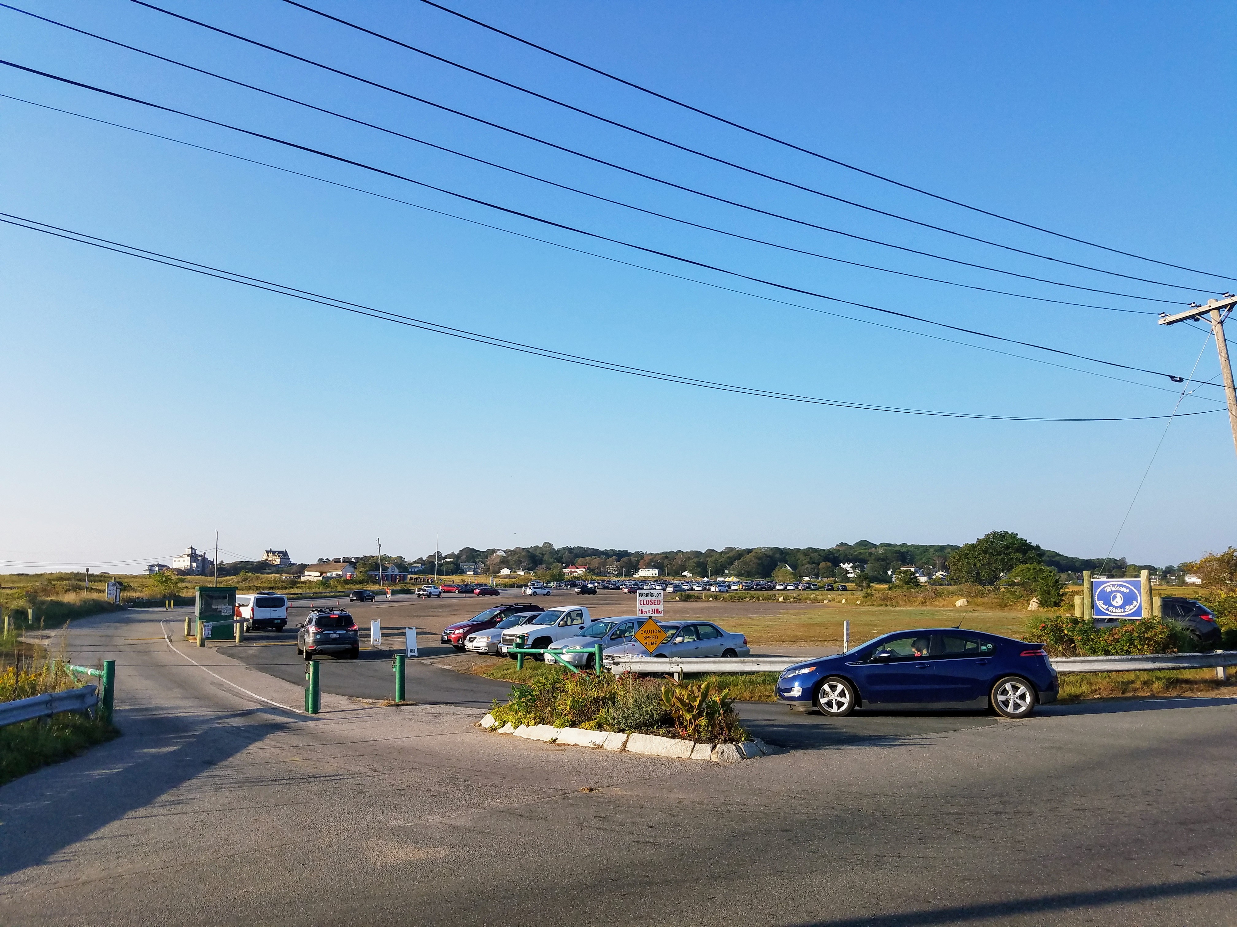
> other practical steps to relieve severe safely, access, and disruption from on-street parking congestion in our beach neighborhoods.“
*park n ride options would ease traffic especially with smartphone reservations/options. Locales like Rockport, Manchester, Provincetown limit cars. Several lots mentioned maximizing extant options such as negotiating with Stop&Shop, Shaws, Fuller, Blackburn, schools, etc. Stage Fort Shuttle already established and more train/bike. Train-trolley services have a rich history here.
TOHP BURNHAM LIBRARY, ESSEX, MA is sited upon another breathtaking Cape Ann landscape with an easy family slope for winter fun.
Great effort! Sweet son gave a proper push to mom, intending to hop aboard, while his older sister raced on.
There’s still time to register today or walk in tomorrow for the Great Marsh Coalition 5th annual special conference on rising water issues and natural systems. Register thru Essex County Greenbelt $20 fee WHEN: November 9, 2017, 8:30AM- 3:15PM. WHERE: Woodman’s in Essex.
From the Great Marsh Coaltion:
Generous Great Marsh coalition symposium supporters (many are coalition members)- local municipalities, Essex County Greenbelt, Essex National Heritage Area, Mass Audubon, Ipswich River Watershed Assoc., League of Women Voters Cape Ann, Merrimack Valley Planning Commission, Metropolitan Area Planning Commission (MAPC), National Wildlife Federation, and The Trustees
What is the Great Marsh Coalition?
The Great Marsh Coalition is a group of organizations and agencies that began meeting in spring 2000 to discuss ways of building a regional consciousness and identity for the Great Marsh. The Coalition supports a coordinated approach to education, research, protection, and management to promote preservation, restoration, and stewardship of the Great Marsh. Current Coalition members include (but are not limited to): City of Gloucester is one of Eight Towns and the Great Marsh, Essex County Greenbelt Association, Essex National Heritage Area, Ipswich River Watershed Association, Massachusetts Audubon Society, Massachusetts Office of Coastal Zone Management, Massachusetts Department of Environmental Management’s ACEC Program, Parker River Clean Water Association, Cultural Alliance of the Lower Merrimack Valley, and The Trustees of Reservations.
Boston Globe article and Continue reading “Boston Globe lists the Great Marsh symposium NOV 9th- public invited”
Great Egret Flying Over Perched Osprey
There is much to chortle about in this latest Cape Ann Winged Creature Update. Early April marked the arrival of both Snowy and Great Egrets, Black-crowned Night Herons and Great Blue Herons. Osprey pairs and evidence of Osprey nest building can be seen wherever Essex Greenbelt platforms have been installed. Northern Pintail and American Wigeon Ducks are stopping over at our local ponds on their northward migrations while scrub and shrub are alive with the vibrant song of love birds singing their mating calls. Oh Happy Spring!
Ospreys Nest Building
Northern Mockingbirds Singing
Gadwall (center), Male Pintail, Mallards, Male and Female American Wigeons
Still frozen, the Essex Salt Marsh panorama was taken yesterday.
Click to see full size.
As we were talking about salt marshes on a recent podcast, the following is information provided by the Massachusetts Bays Program:
The Essex Salt Marsh is part of the 17,000 acre Great Marsh that extends from Cape Ann into New Hampshire. Salt marshes are found in coastal areas. These unique ecosystems are formed within protective estuaries and support numerous plants and animals. Salt marshes are among the most productive lands on earth, outcompeting even the best-managed farms. Two-thirds of all marine fish and shellfish depend on salt marshes during some portion of their lives.
Salt marshes are divided into two general vegetation zones. The Low Marsh is flooded twice daily by the incoming tide and is dominated by Spartina alternifolia (low salt marsh grass). The High Marsh is flooded sporadically and is dominated by Spartina patens (high salt marsh grass). Salt marshes contain tidal creeks, pools, and islands of high ground, and serve as highly efficient pollution filters.
Nationwide, vast areas of salt marsh have been destroyed by filling, dredging, and developing upland areas. The Great Marsh has escaped much of this destruction, but it is impacted by pollution runoff and mosquito control ditches built in the 1930s, and by road and rail crossings, which restrict tidal flows to upstream marshes.