Beautiful Fish: Unicornfish -By Al Bezanson


With Gloucester awash from a wicked storm nobody knows what may swim into town.  If you come upon a creature like this please notify NOAA, for the unicornfish is quite rare.   According  to Fishes of the Gulf of Maine by Bigelow and Schroeder (1953) only two specimens have been found, both caught on the western edge of Georges in 1930 by the schooner OLD GLORY.

http://www.gma.org/fogm/Alutera_scripta.htm

Channel 7 news #GloucesterMa LIVE storm coverage

In case you missed  Channel 7 report from Fisherman at the Wheel Stacy Boulevard. 19 foot waves according to buoys.


They’ve been there all day

IMG_20180302_093511.jpg

Riley storm post earlier today 


Alicia Unleashed- Mr. Beardo

Episode 75

With special “silent” guest Mrs. Beard’O! Recorded 3/1/18 with Alicia and BSide.

cx

*Full disclosure, there was typing at the begining…. we’re sorry. It’s always a thing with Mr. Beard’O! Also stick to the end-ish for a special giveway!

We talk about Talia’s Last Play at Waring!
B discusses SEE, CLICK, FIX site!
The Gorton’s sign got a makeover!
B signed up for a MS walk in Newburyport.

**If you are here for the Beard skip to 14:14 mark.
Mr. Beard’O talks about being on the USA Network for Football Fanatic, talking about how social media got him all the connections for him to participate in this show!

We ask Mr. Beard’O why he decided to create a beard product, what is next in the product line (we even give him ideas for upcoming events and holidays) can we say Free Marketing?! How he was inspired for different scents and the process.
You can find bottles in Just Kuts in Waltham
Radiance Aveda In Salem.
*If you are a local business or know of a business that could benefit from having Beard’O Oil in their store, please contact Mr. Beard’O.

Shout out to Sam (1:01.30) and her man!

Socials and Sites!
To Donate to BSide in her walk-http://main.nationalmssociety.org/goto/DorysSquad
http://www.mrbeardo.com

Insta:
Dana_blatchford

Facebook: (in searches)
MR BEARDO BEARD OIL-Facebook Group

Coastal flooding roads closed & New Balance Field at Newell Stadium

Receding now- 3 hours after high tide

IMG_20180302_134348


Life of Riley – Nor’easter storm #GloucesterMA

March 2, 2018. Riley so far (photos and 2min video low tide 8:30–11:15AM,the first high tide)

IMG_20180302_095216

IMG_20180302_093610
Fishing boat returns to port March 2 2018 ahead of high tide

Continue reading “Life of Riley – Nor’easter storm #GloucesterMA”

LIVE FROM ATLANTIC ROAD WITH HUGE WAVES THREE HOURS BEFORE HIGH TIDE

New Bling at the Library

GMG Jimmy and I recently attended a program held at the Rose Baker Senior Center presented by Beth Welin, Directory of the Manchester Historical Museum.  This program focused on the Grand Hotels of Gloucester in the Gilded Age and included many hotels familiar to Gloucester residents: Oceanside, Fairview, Hawthorne, Moorland and Thorwald.  Ms. Welin reported that many of these grand hotels suffered major fires. Several of those fires were suspected arson.

This piqued my interest and, armed with some name and dates,  we went directly from the program to Sawyer Free Library to do some research.  Technically, I did the research.  I think GMG Jimmy enjoyed some coffee.  I digress.

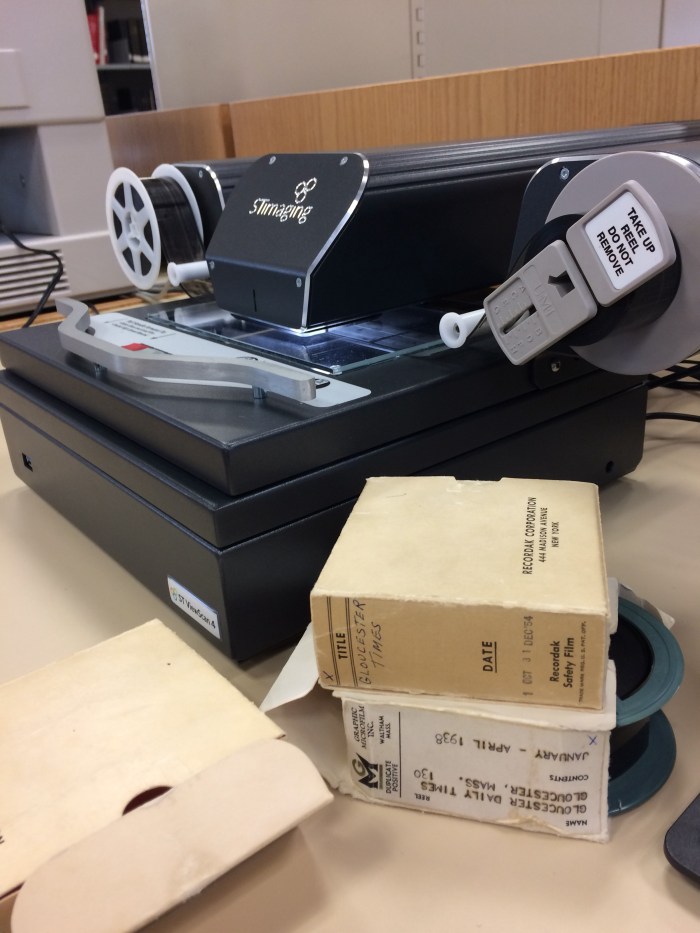
As I approached the Gloucester local history collection,  I was delighted to see some new equipment available for researchers interested in reading microfilm.  Archivist Katelynn Vance was pleased to show off the new digital scanner from which you can manipulate, save to flash drive or email the images!!  WOOT WOOT  She also took some time to show me some of the other microfilm available for research besides a full run of the Gloucester Daily Times including the Boston Globe and the New York Times.  I was in research heaven.  I had such a good time, GMG Jimmy had to drag me away, but I’ll be going back sooner than later.

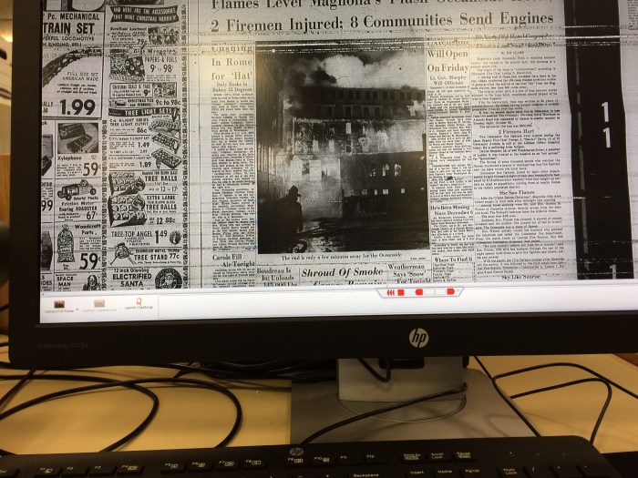
This is one of the images as I saw it on the new scanner from the December 11 1958.  I sent myself a jpeg file of this image to my email. BOOM!

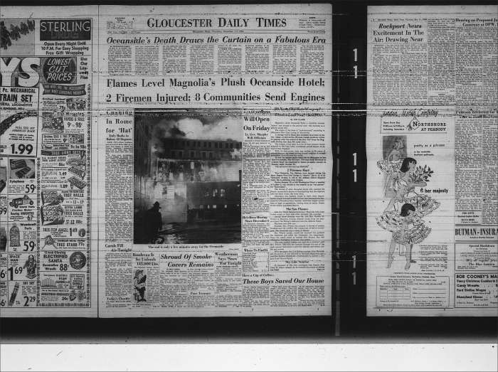
This is the picture file….MAGIC!

ViewScan_0000 (2)

Welcome to the Sawyer Free Library, STimaging ST ViewScan 4! I love you.

GOOD MORNING GLOUCESTER! BROUGHT TO YOU BY ROCKY NECK

Calm before the storm–from an exquisitely sunny and peaceful morning on the Neck.


SNOWY OWL FEATHERS IN THE MOONLIGHT -By Kim Smith AND REQUEST FOR HELP

Hedwig is the gift that keeps on giving! What a joy to see her awakening in the rising full moon last night. She preened and fluffed, then flew through the moonlight to a nearby phone pole.

The wind was whipping up and ruffling Hedwig’s feathers, making her look extra fine in the glow of the Snow Moon rising.

Dear Friends,

While I am sorting through the challenges of one of the hard drives for my Monarch film crashing, I have been organizing the Snowy footage. Captured in photos and on film, we have her bathing, passing a pellet, pooping, eating, flying, and much more, and is going to make a terrific short film. It’s a mystery to me exactly where she goes when she disappears for several days and I am hoping to document every aspect of her stay in Gloucester. She has been spotted at several locales in East Gloucester, Salt Island, and Twin Lights but, if by chance, she is a regular visitor to your yard, please write and let me know. The best way to keep the information from becoming public knowledge is to email me at kimsmithdesigns@hotmail.com. I am also looking for a few minutes of footage of a Great Horned Owl (Bubo virginianus) as they are closely related to Snowies (Bubo scandiacus), so please write and let me know if you have a resident Great Horned Owl. Thank you so much for any leads given 🙂Full Snow Moon Rising

Official :Gloucester Issues Coastal Flooding Statement

28575697_10155035273927331_4130520960677695813_n
Gloucester Emergency Flooding Alert [Code Yellow Alert Issued 3/1/2018 6 PM]
LONG DURATION COASTAL STORM THURSDAY NIGHT THROUGH SATURDAY
Tides will be astronomically high from Thursday night (3/1/2018) through all of Saturday (3/3/2018) with a coastal storm and storm surge increasing coastal flooding and property damage. Power outages, road closures, and other emergency incidents are expected in the next 24 to 48 hours and we strongly recommend all citizens to prepare accordingly.
Additionally, we caution all citizens who are in low lying areas that are prone to flooding to be aware and prepare accordingly. Any home or business that was previously affected by recent storms and flooding should especially take caution.
Coastal properties facing East, NorthEast may be severely affected by the predicted storm surge and significant wave action.
Precautionary measures should be taken immediately to best prepare, including voluntary evacuation prior to the storm. All residents should avoid these areas, as well as avoiding driving through any flooded areas.
Strong winds may cause power outages and we are asking citizens to shelter in place. If your home is being flooded or if you are in danger, call 911 for immediate assistance. Emergency teams are prepared to assist anyone in need so call 911 right away.
Roads may be slick in areas, so we remind all to take caution if driving. Roadways most prone to splash-over at astronomically high tides will be at greatest risk of inundation.
Updates will be forthcoming and will be shared on the City of Gloucester website and social media pages so please visit http://www.gloucester-ma.gov. Thank you for your assistance and please use 911 for any flooding or emergency needs.
# # #
ADDITIONAL RESOURCES AND PROVIDER CONTACT INFORMATION AS FOLLOWS:


POWER OUTAGES
National Grid has been preparing for power outages in different areas across the North Shore, including Gloucester. If any outages do occur in your area, it is imperative that they be reported via the National Grid Customer Service or Outage Reporting phone lines as listed below. Every outage phone call that we receive is logged into our outage tracking system and better enables us to pinpoint the location of the issue. The sooner National Grid can identify the location of the issue, the quicker a response can be sent.
The Customer Service Line is: 1-800-322-3223
The Outage Reporting Line is: 1-800-465-1212
REMINDERS/ SAFETY INFORMATION
Flood safety tips: http://www.mass.gov/index.php/service-details/flood-safety-tips
Storm preparedness and safety information: http://www.mass.gov/index.php/service-details/winter-storm-safety-tips
Power outage preparedness and safety information: http://www.mass.gov/index.php/service-details/power-outage-safety-tips
Safety and preparedness tips for extreme cold: http://www.mass.gov/index.php/service-details/extreme-cold-safety-tips
Winter safety tips for pets: https://www.mass.gov/service-details/winter-pet-safety-tips
MASSACHUSETTS EMERGENCY MANAGEMENT AGENCY SITUATIONAL AWARENESS STATEMENT
Latest weather and emergency reports can be seen using the following links and resource lines:
Live weather maps and climate information: http://memamaps.maps.arcgis.com/apps/MapSeries/index.html?appid=0da6e4d888b74317b52b7a5064aa3dc2
Power outage map reporting: http://mema.mapsonline.net/public.html
Latest situation charts, messages and social media friendly messaging: https://www.facebook.com/MassachusettsEMA/

# # #

FOR MORE INFORMATION, PLEASE CONTACT:
ED MANAGER CHIEF ERIC SMITH AT ESMITH@GLOUCESTER-MA.GOV


28514427_10155035275112331_348316864993323096_o