MARINE FORECAST…
Sat: W winds 5 to 10 kt…becoming S in the afternoon. Seas 2 to 3 ft.
Sat Night: S winds 10 to 15 kt with gusts up to 20 kt. Seas 3 to 5 ft. A chance of rain.
Today we’re looking at mostly cloudy conditions with temps in low 40’s. Winds rather light from the west at 5-10mph switching to the south late In the day . Saturday night chance of showers with mostly cloudy skies lows around 40 ..
Ok so I wanted to do something different and explain different aspects of the weather . So with that being said let’s start out with “The High Pressure”
Ok so what’s a “High Pressure”
A high-pressure area, high or anticyclone is a region where the atmospheric pressure at the surface of the planet is greater than its surrounding environment.
Winds within high-pressure areas flow outward from the higher pressure areas near their centers towards the lower pressure areas further from their centers. Gravity adds to the forces causing this general movement, because the higher pressure compresses the column of air near the center of the area into greater density – and so greater weight compared to lower pressure, lower density, and lower weight of the air outside the center.
However, because the planet is rotating underneath the atmosphere, and frictional forces arise as the planetary surface drags some atmosphere with it, the air flow from center to periphery is not direct, but is twisted due to the Coriolis effect, or the merely apparent force that arise when the observer is in a rotating frame of reference. Viewed from above this twist in wind direction is in the same direction as the rotation of the planet.
The strongest high-pressure areas are associated with cold air masses which push away out of polar regions during the winter when there is less sun to warm neighboring regions. These Highs change character and weaken once they move further over relatively warmer water bodies.
Somewhat weaker but more common are high pressure areas caused by atmospheric subsidence, that is, areas where large masses of cooler drier air descends from an elevation of 8 to 15 km after the lower temperatures have precipitated out the lighter water vapor. (H2O is about half of the molecular weight of the other two main constituents of the atmosphere—Oxygen, O2, and Nitrogen, N2.)
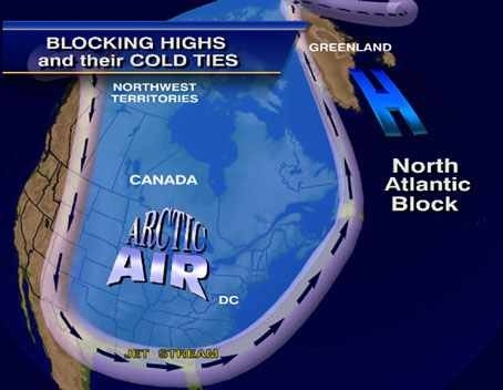
High pressures can be both our friends or enemies .. Case in point if u have a High Pressure like this one picture below …

Then HOUSTON we have a problem .. This is called a “Blocking High” most common in winter months . When u have a very strong high pressure over Greenland , it tends to put on the brakes and cause a traffic jam of Weather across our country .. Most times results in stalling or retro grading monsters off the east coast resulting in lots of snow .. So if u here of A Greenland Block has set up just be ready for long duration storms..
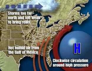
Now our friend “High Pressure” seen below …

Is our warm mild position off the East Coast .. Bermuda Highs always bring in mild / warm / and tropical weather in the Summer months … Bermuda highs are often our good friends as far as weather goes .. How ever don’t be fooled During August ESP when Bermuda Highs can steer Tropical systems up our way ! IE. Tropical Storms / Hurricanes… So there’s Blocking Highs / Fair Weather Highs / And Bermuda Highs … Hope u enjoyed … Have a Wonderful Saturday !!!
Peter J Lovasco
GMG
Weatherman


Great info Pete. Thank you and Love it!!!
LikeLike
Very good – weather man and love the toon’s 🙂
LikeLike
Didn’t blow the forecast it’s called being human – but I thnk your post was pulled?
LikeLike