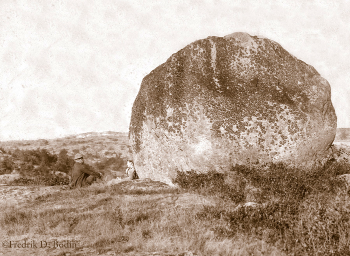
Fred Bodin (https://www.facebook.com/BodinHistoricPhoto) and I have a problem. We’ve been trying to locate this 30foot high boulder, but we have not yet found it.
You would think that something this large would be hard to miss. Google Earth, drive-by observations and even a few tentative walks in the woods have not revealed its location. There are, however, a few clues.
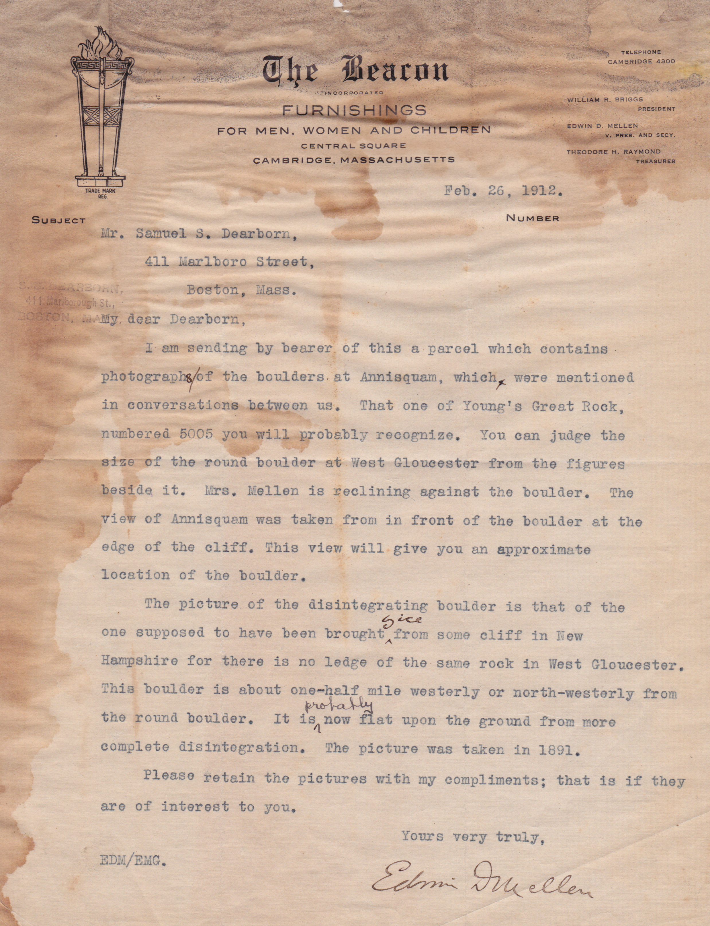
Fred has uncovered a letter dated February 26, 1912 from Edwin D.Mellen of Cambridge to Samuel S. Dearborn of Boston which mentions photographs taken in 1891 and refers to the “round boulder at West Gloucester.” He also notes a second photo of a view of the Annisquam that was “taken from in front of the boulder at the edge of the cliff.”
Here is the letter:
 And here is the second photo:
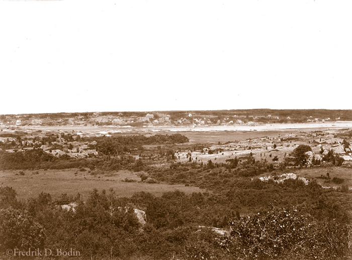 So seems pretty clear that the large boulder is somewhere on the west side of the Annisquam, perhaps high above Wingaersheek Beach.
Unless someone identifies this landmark soon, Fred and I will have to do the unthinkable: get out of the car and perform a scientific grid search of the entire area. That means exercise.
Please save us from that frightening prospect and share with us any information you have regarding the boulder’s whereabouts. SOMEONE OUT THERE KNOWS WHERE THIS ROCK IS.
All images © Fredric D Bodin


That’s THE ROCK! I think. Go up Squam Rock Road (off Walnut) – it’s at the top of the first big hill, to the right of the stone wall, at the top of the pasture. I climbed that thing in clogs when I was a kid many times and recently climbed it, 30 years later. Getting down was scary!
LikeLike
I don’t think so. The Mellen letter makes it clear that it is in West Gloucester, not Annisquam. Also, the second picture looks like it is of Annisquam from the west side of the river.
LikeLike
Hey, Courtney === even though others are saying that it ISN’T “Squam Rock” – my sister and I agree with you… We climbed it in our youths and our children and grands have also met the challenge… The trees have all grown up so tall that it’s impossible now to step back and see the roundness of the rock. The letter clearly states that the photo is taken in Annisquam, no? and the “cliff” is exactly behind where one runs up to get a start on the feat of climbing the ROCK! I bet we’ll win out on this discussion! :+)
LikeLike
There have been half a dozen good guesses on my FB Page and there will be more (https://www.facebook.com/BodinHistoricPhoto) that may help you figure this out. One is the “Dark Hole” in West Gloucester.
LikeLike
Where is Dark Hole?
LikeLike
Much local folklore is coming out about this. The Dark Hole is near Sunset Mountain, at the end of Fernald Street. Just got two more comments: “I know where that is! Totally wooded area now and there’s a cache nearby”; and “Brett says that growing up he believed “green galloop” was in dark hole.” I think we’re getting closer.
LikeLike
I agree that it is Sunset Mt area looking at Annisquam on left . You can pick out Bent property in Annisquam, Lobster Cove, Mill stream and river.
LikeLike
looks like it should be on Cole’s Island Road..near where the new road/driveway went in at the land for sale
LikeLike
Essex County Greenbelt:
could it be a glacial erratic: http://www.ecga.org/explore_and_engage/view_property/1100-sunset_mountain (see icon under features)
check out the photos on this page: http://www.ecga.org/explore_and_engage/view_property/1098-tompson_street_reservation#
I suppose you two gents might still have to investigate for verification. What? Fresh air and exercise?
LikeLike
If it comes to that – fresh air and exercise – our consolation will be the nearest restaurant for lunch: Lobsta Land!
LikeLike
The best clue is the second photo that shows Annisquam from the west side of the river. It is said to have been taken “in front of the boulder at the edge of the cliff.” There is a heavily treed area off of Atlantic Street (to the east) which has a summit (the “cliff”?) about 50 feet higher than the marsh and beach that stretches easterly toward the Annisquam River. I believe it would offer a view similar to that shown in photo 2. Google Earth shows a rocky outcropping (http://tinyurl.com/d82jfhl), but the large round boulder might well be hidden by the trees. Another possibility is the area near Waterman Road near Wingaersheek. The view is similar, but extensive construction over the past hundred years may have displaced the boulder – or it could be in someone’s backyard not clearly seen from the road.
I’ve checked out some of the other areas that have been suggested. Although the topography of the Sunset Mountain area is promising, I believe that it is too far away from the River to present anything like the view seen in photo 2.
Although Mr.Mellen’s letter mentions boulders in Annisquam, he describes the “round boulder” as being in West Gloucester and uses photo 2 for further identification of its location. Also Squam Rock is more of an outcropping than a boulder. There are many photos of it online and they don’t seem to resemble Round Rock.
Many thanks to all who have offered assistance. Please keep the suggestions coming and we will check out as many as possible.
LikeLike
Squam Rock
LikeLike
Awesome that you found that piece of history. I am the great- grandson of Edwin D. Mellen and researched my family history from the town hall last July. Adele Mellen Richardson was my Grandmother.
LikeLike