Published by Fredrik Bodin
Fred Bodin is a photographer who owns a gallery on Main Street in downtown Gloucester, MA. The gallery features Fred's land and seascapes, as well as historic images printed from the old negatives.
View all posts by Fredrik Bodin
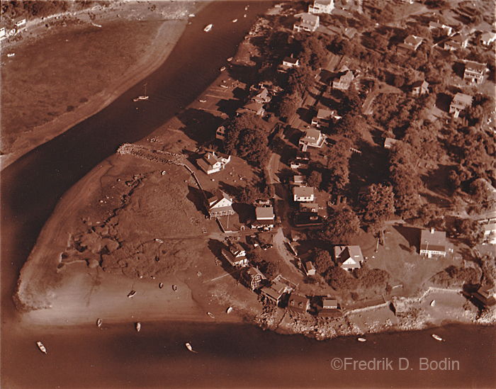


Thurston’s or Wheeler’s Point?
LikeLike
Where the mill comes into the Annisquam. It doesnt look like that anymore.
LikeLike
Wheelers
LikeLike
Where the Mill meets the Annisquam although it no longer looks like that.
LikeLike
What is different now?
LikeLike
Yes Wheelers Point, where the Mill River joins the Annisquam River.
LikeLike
Tomorrow answer to question Mr. Bodin.
I think Whale Cove road on Whale Cove Rockport Mass ?
LikeLike
erosion
LikeLike
The google map version shows more water. Hard to tell from new to old who is at high tide and who is at low. But really not that much difference. All houses are still there although some have water at the front door, under the piers at high tide. If you put walls and jetties up you’re going to get erosion. Without them, you get coastal migration. Barrier beaches left to their own devices migrate inland over time. Some places they migrate out. Cape Ann is lucky as granite migrates very slowly.
LikeLike
Thanks Paul, I now feel grounded like a rock…
LikeLike
I think it looks like Wheeler’s Point does today. I recognized the five little cottages which are all still there; the last one on the right is Steve Dexter’s.
LikeLike
This is Wheelers Point but some time ago. I lived on Wheelers for a long time, my house was the one near the water with the flag pole. I miss the old neighborhood.
LikeLike
This photo is at low tide. This picture is prior to 1965, that is when the pier and float was put in at 6 Riverside.
LikeLike
Sure looks different today – had a friend that lived in riverpoint…been here a very long time ago…1966-1967. Thanks 🙂
LikeLike