 First named Tragabigzanda after a Turkish Princess, Cape Ann was later renamed by King Charles in honor of his mother, Queen Anne. The granite rock formation at the tip of Eastern Point looks to me like the silhouette of a figurehead on a ship’s bow. Historically though, Mother Ann is thought to represent either a reclining Puritan woman or Anne of Denmark, the mother of King Charles.
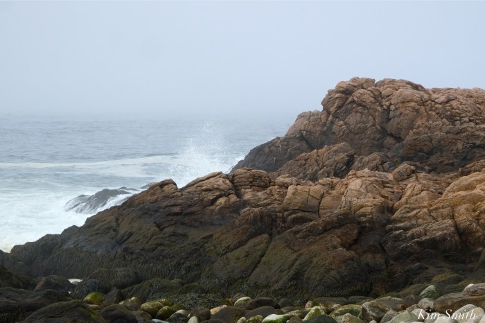
I have been experimenting with different focal lengths with the new 1.4 teleconverter. The first photo was taken at 400mm with the teleconverter. I am not sure if the fog or the lens is creating the softness but I think it’s going to be lots of fun nonetheless, especially for wildlife.
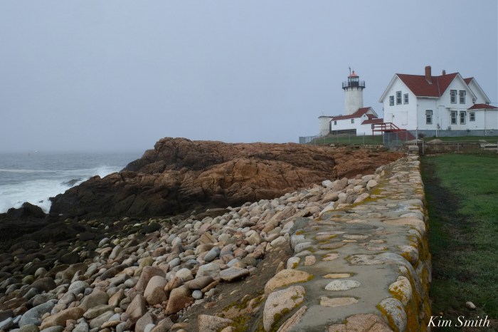


All of Cape Ann was named Tragabigzanda by Capt. John Smith, who explored the New England coast in 1614 from mid-coast Maine to Cape Cod, naming everything in sight for one member of the English royal family or another (his trip was financed by Prince Charles (later King Charles I), except for the Isles of Shoals (which he named the Smith Islands), and Cape Tragabigzanda, after a Turkish woman to whom he’d been given as a slave by her brother, who had captured him in the Austro Hungarian/Turkish wars in the 1590s. Of course she and Smith fell in love, she let him escape, and he walked back to England, via Russia and Scandinavia, (presumably the last leg by sea). Fast forward back to 1614, skipping the Jamestown and Pocahontas story: Smith arrives back in England, reports to Prince Charles, who no doubt said “nobody will be able to pronounce Tragabigzanda; I’ll name it after my mother Anne”. Or so the story goes .
LikeLiked by 4 people
Thank you Tom for filling in the story; truly a fascinating piece of Cape Ann’s history.
LikeLike
love this story that’s why we have Cape Ann
LikeLiked by 1 person
Tom is a wealth of information, on many topics!
LikeLike
Kim these are amazing – thank you! I did not know we had a Mother Ann. ❤️
LikeLiked by 1 person
Thank you Kristie for writing. You can see her by walking the Audubon area along the coastline.
LikeLiked by 1 person
Thanks for the post Kim. Great post an insight above history 101 – Tom H. I also remember Mountain Ann off RT 128 history and fun! 🙂 Dave & Kim 🙂
LikeLiked by 1 person
Unfortunately, New Hampshire’s Old Man of the Mountain collapsed, but that was a series of cliffs that really jutted out. Our Old Mother Ann hopefully won’t share the same fate.
LikeLiked by 1 person
Never know with mother nature! 🙂 Dave
LikeLike
This is the first time I’ve seen photos to put Mother Anne in context with surrounding landscape. Thank you!
And Tom, keep sharing the history lessons. Love them.
Great post!
LikeLiked by 1 person
Thank you for commenting Susan. Tom is terrific!!
LikeLike
While on Sunday drives with my parents and grandfather as a little girl we would always drive around the Backshore and my grandfather would make a game out of find the rock formation that looked like George Washington looking directly up to the sky. If you are driving from Farrington Avenue heading towards Good Harbor Beach it is just before the Atlantis Motel. You can’t see it well during high tides, but wow is it visible during low to mid tide. See who can find it and post a photo of it…………………..Grampa Orrin H. Douglass from Rocky Neck would be proud!!!! 🙂 🙂
LikeLiked by 1 person
In the mid to late 50s, My grandfather did the same drive with me and my grandmother. Each ride, at the lighthouse, we would get out of the car until I finally saw Mother Ann, I can remember the day. From then on she was a “drive by” on the way to the ice cream stand between Gloucester and Rockport. We lived on Bass Rocks, sorry to say I never did see George Washington. Perhaps someone has a photo. I would love to add that stop to the family drive arounds I now conduct. BTW, last year we ran into ~ at our “round the bend” stop ~ overlooking GHB ~ KIM SMITH! We now call that the “celebrity stop” 😉
LikeLiked by 1 person
Oh Mary, it was so fun to see you there with your family. What a nice surprise!!
Thank you for sharing your lovely story. ❤ ❤ grandfathers!
LikeLike
Thank you for writing Mary Ann; loved your story and will definitely have a look for George Washington 🙂
LikeLike
Have you seen Grandpa’s footprints on the big cliff off Rte. 133?
It’s next to the path to Thompson’s Reservation.
LikeLiked by 1 person
All these great landmarks, thank you Escape Pod!
LikeLike