
Tag: Purple Sand

A walk on Salisbury Reservation with seals, waves and purple sand


Salisbury Beach Geology and Barrier Island Dynamics
The following is from the publicly released document “Salisbury Beach State Reservation Barrier Beach Management Plan 2008” Masschusetts DCR.
Pre barrier island past
Salisbury Beach is a barrier beach that is separated from the mainland by a large salt marsh which contains several tidal creeks. The physical area known as Salisbury Beach was created by the reworking of sediments deposited by glaciers as they melted and receded to the north 15,000 to 18,000 years ago. As it receded, the glacier left bedrock deposits which are present in small areas at the southern part of the Reservation, near the mouth of the Merrimack River. The source of the sand at the beach was historically a paleodelta deposited offshore as the glacier receded.
Barrier Island formation
The development of barrier beach/dune systems began approximately 6,300 years Before Present (B.P.). As previously described, prior to 10,500 B.P., the region was under an ice age load which caused a general subsidence. During the waning of the glacier, first the sea level rose significantly above coastal lowlands, and then the land rebounded and became elevated higher than average sea levels. As the sea rose, it eroded glacial deposits offshore which formed the foundation of a barrier beach/dune system. This underlying foundation consists of glacio-marine clay which is located at depths of 40 feet or more.
Sand and gravel carried along the shore by waves and currents subsequently accumulated on top of the clay to form a spit. The area between the spit and the mainland was mostly open water. Over time, sea-level rose and the spit continued to enlarge and migrate westward. The protected bay behind the spit filled in with sand, became shallow and developed into a salt marsh.
Barrier Island Dynamics
Beaches are always in a state a flux. Climate, the intensity of the winds and currents, storms, available sediment supply and land-use determine the profile of the beach. The sand that accumulates on beaches comes from northern mountain boulders (often transported by rivers) which were finely ground first through years of glaciation and water by erosion as a result of storms and frost. The littoral current which runs from north to south during north/northeast winds transports sand down the coastline. This current is powerful, and the undertows and rip currents act like huge conveyer belts carrying sand southward to replenish beaches further down the coastline. If the littoral current is obstructed by structures such as jetties and groins, the beach will balloon out to the north of the obstruction “damming up” the littoral drift which would have replenished the beach to the south. Similarly, transport of sand in the onshore or offshore direction (cross-shore transport) results in an adjustment of the beach toward an equilibrium profile. The major source of cross-shore sediment transport comes from the paleodelta located offshore of the Merrimack River. High waves and water levels during storms result in accelerated and modified longshore and cross-shore sediment (sand) transport processes.
Not only do dunes protect inland areas but they supply sand to the adjacent beach system, thereby increasing its ability to dissipate storm waves. By absorbing much of the force of the waves, dunes provide protection to landward areas from storm damage and flooding.
A healthy barrier beach system contains primary dunes and secondary dunes. If the sand dunes at Salisbury Beach were free from human interference, predictable geological processes would occur. High energy storm waves attack the beach and dune face. Sand is transported in an offshore direction to build sandbars. The decreased depth of the offshore area causes waves to break further offshore and away from the dune face. Less energetic waves, consequently, directly hit the beach and dunes. Vegetation on the dunes provide stability through its root system that holds the sand in place and by trapping windborne sand particles blown from the dry portion of the beach, increasing the volume of sand in the dune.
The dynamics of Salisbury Beach’s barrier island dunes and beaches.
The sand dunes at Salisbury Beach are moving westward with a motion similar to that of a bulldozer tread: a rolling, “going over itself” motion. Some natural factors, such as rising sea level, make this process inevitable, while others, such as littoral drift and dune vegetation, make it a relatively slow process. Storms can create changes very quickly. However, human activities also accelerate this process. People, with their desire to visit or live on the beach, often destroy the very resource that attracts them and the resources that provide storm buffering and flooding protection.A jetty located north of the Reservation in Hampton, New Hampshire, currently interrupts the flow of sand onto the northern section of Salisbury Beach. The beach is steeper south of this barrier. The jetty along the northern shore of the Merrimack River, provides protection to the navigation channel into and out of the Merrimack River and obstructs the flow of sand to the south towards Plum Island.
Beaches typically migrate landward due in large part to reduced sediment supply and rising sea-levels. The rate of relative sea level rise is currently about one foot per 100 years; however, the Intergovernmental Panel on Climate Change (IPCC) predicts that sea-level rise and its risk to coastal resources will accelerate over the next 100 years. Conservative projections of sea-level rise by the end of the century range from 4 to 21 inches, while projections given a higher emissions scenario range from 8 to 33 inches (CHC, 2007). Given on-going coastal issues and climate change, land mass forms in this dynamic system will constantly change over periods of time.
Spread The GMG Love By Sharing With These Buttons:


WHY THE SAND IS PURPLE AND PINK ON CRANE BEACH, PLUM ISLAND, AND OTHER NORTH SHORE BEACHES
Hard to miss in the wintertime both at Crane Beach and at Plum Island are the layers and swirls of pink and purple sand. On a recent visit to Revere Beach I noticed there were also rivulets of pink and purple sands.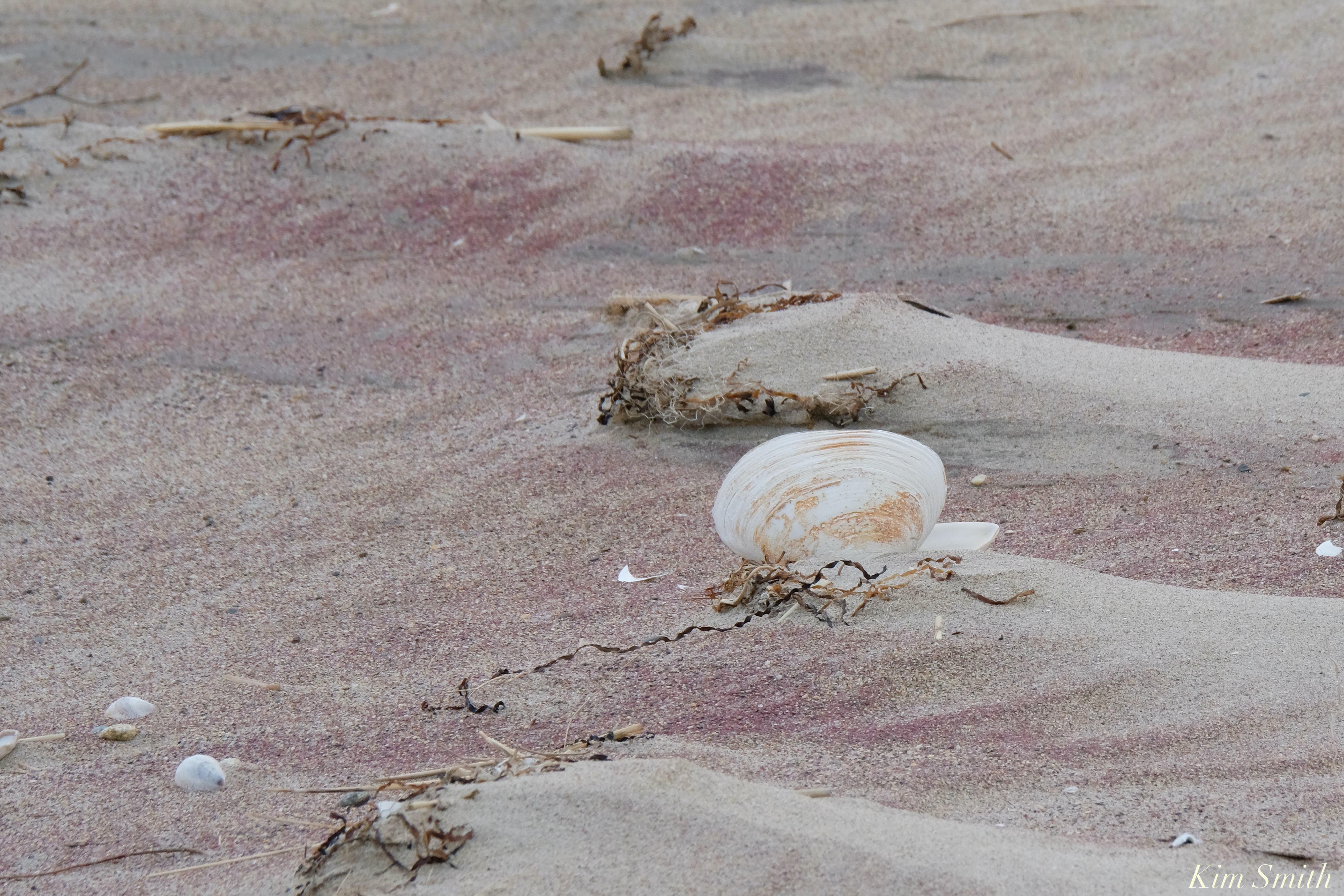
The pink and purple are mineral deposits of rose quart and garnet and come to north of Boston beaches via the White Mountains. Water and wind worn rock is carried in river waters until it meets the ocean and becomes deposited on barrier beaches. We mostly see the garnet and quartz deposits in winter as storms erode the dunes, leaving the heavier minerals exposed. During the spring and summer, the lighter white quartz sand blows back over the dunes and covers the heavier sand.


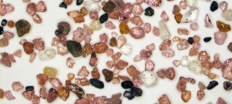
JEOL is a supplier of electron microscopes, ion beam instruments, mass spectrometers and NMR spectrometers. On a visit to Plum Island looking for Snowy Owls, several JEOL employees found purple sand. They analyzed it using an optical microscope, a scanning electron microscopes (SEM) and an energy dispersive X-Ray spectrometer (EDS).
At first look under the optical microscope, the granules of sand appeared like scattered jewels of many colors; predominantly glassy pink angular grains, with smaller quantities of milky white rounded grains, clear angular grains, black grains (some magnetic and some not), and even the occasional green.
What could be the cause of the purple color? The answer was one that came as no surprise to the scientist, but was exciting for the beach walkers because they had an exact answer to a question that no doubt is one that many people have when they visit Plum Island – which was actually named for its beach plum bushes, not the plum-colored sand.
When large amounts of fine grained pink is intermixed with a smaller number of darker grains and dampened by rain or sea water the human eye will “see” the sand as a much darker pink to almost purple. The two most common pink minerals are rose quartz (while quartz is one of the two most common minerals on earth, the pink rose quartz variety is not so common ,especially in the New England geology, and is found only in a few isolated pegmatite deposits in NH & southern Maine which are where most gemstones originate) and the solid solution series of almandine and pyrope garnet which is also a very common mineral (and is quite common in the Seacoast area from the abundance of metamorphic rocks called mica schist and from contact metamorphism. This is also why many commercial sandpaper products have a pink color as the angular hard gains of almandine / pyrope garnet are the perfect abrasive. The most likely candidates for the white and clear are any of the feldspars and or quartz. The green is most likely epidote. Just based on the optical examination these are no more than educated logical guesses (but still guesses).
Vern Robertson, JEOL’s SEM Technical Sales Manager, originally examined the grains under a low power optical stereo microscope with the above conclusions. In addition to providing technical and scientific support to JEOL SEM customers for a multitude of applications, Vern holds a degree in Geology. After a cursory look optically, it was time to get down to some spectroscopic analysis to determine the actual mineral species present in the sand.
Individual grains of various colors were selected and mounted for examination with the JSM-6010LA+ InTouchScope SEM and for analysis using EDS. The SEM allows much higher magnification imaging with greater depth of field than a traditional OM and the low vacuum capability allows examination of the sample without the traditional conductive coating that needs to be applied for SEM imaging. However, it generates images in only black & white (electrons have no color!). One specialized detector in the SEM, the Backscatter Electron Detector, yields images with the gray level intensity directly proportional to the average atomic number (or density). This means that minerals containing only lighter elements like O, Si are darker in appearance to minerals that contain heavier elements like Fe or any of the metallic or rare earth elements.
Once located, each grain can be analyzed with the EDS. When an electron beam hits a sample it creates not only an image from the emitted electrons but creates X-rays, which when collected in a spectrum, indicate what elements are present and at what concentrations. This allows not only the elemental composition of the individual grains to be determined but the concentrations can be compared to known stoichiometry of the suspected mineral grains. The combination of color and magnetic properties from OM examination and the chemical makeup of the individual grains yield the answer.
The purple color (or more appropriately, pink color) comes from the abundance of almandine-pyrope garnet with a nominal solid solution composition of Fe3+2Al2Si3O12 to Mg3+2Al2Si3O12. As expected, the white grains are a mix of feldspars but mostly K-feldspar (potassium alumino-silicates) and quartz SiO2. The black nonmagnetic grains were a mix of a pyroxene called augite which showed its characteristic strong cleavage, (Ca,Na)(Mg,Fe,Al)(Si,Al)2O6 , and a mix of ilmenite FeTiO3 and hematite Fe2O3 which are the magnetic components. The green was confirmed to be epidote Ca2(Al,Fe)3(SiO4) 3(OH). With the exception of the high concentration of garnets the rest are common minerals one would expect to find in sands.
Spread The GMG Love By Sharing With These Buttons:

Sandy Point State Reservation
Sandy Point State Reservation is at the end of Parker River Wildlife Refuge.
The reason the sand is purple is due to quartz and manganese garnet deposits from the nearby hills that washed down to create the purple colors and is most visible after storms.


