Wednesday March 19th , 2014 Cape Ann Weather ..

Marine Forecast ….
Wed E winds 10 to 15 kt. Seas 2 to 3 ft.
Wed Night SE winds 10 to 15 kt with gusts up to 25 kt. Seas 2 to 4 ft. Rain. Vsby 1 to 3 nm.
High tide 1:33AM / 9.6 / 1:58PM / 9.3
Low tide 7:44AM / -.04 / 8:00PM / 0.0
Sunrise 6:44AM Sunset 6:55pm
Moon :
Waning gibbous
Visible: 97% ↓
Age: 16 Days

Video Cast ….

20140318-224742.jpg

20140318-224818.jpg
Computer model maps of March 25th / 26th .. Shows track / strength / winds / snow amounts .. Not a forecast just what the ECMWF is showing .. Could it happen sure , will it not sure at this time … To early to speculate .. Enjoy …

20140318-225042.jpg

20140318-225054.jpg

20140318-225106.jpg

20140318-225118.jpg

20140318-225138.jpg

Tuesday March 18th , 2014 Cape Ann Forecast..

Marine Forecast ..
Tue NE winds 5 to 10 kt. Seas around 2 ft.
Tue Night NE winds 5 to 10 kt. Seas around 2 ft.
Video Forecast…

Hourly Forecast ….

20140317-153255.jpg
Extended Forecast….

20140317-153354.jpg
One computer model on Steroids !!

20140317-153451.jpg

20140317-153837.jpg

Monday March 17th , 2014 Cape Ann Weather..

Marine Forecast…
Mon N winds 10 to 15 kt. Gusts up to 20 kt in the morning. Seas 2 to 4 ft.
Mon Night N winds around 10 kt. Seas 2 to 3 ft.

Today mostly sunny with some high clouds highs in the upper 20’s to lower 30’s.. North winds around 10mph ..
Monday night mostly clear with lows in the teens to lower 20’s .. Light north east winds 5-10 mph …
Tuesday sun and clouds 33 degrees with east winds 10-15 mph..
Hourly Forecast …

20140316-170849.jpg
Extended Forecast…

20140316-170940.jpg
Long Range outlook from the NWS Boston , frigid late March with a new “Polar Vortex ” … Here’s a look at late March …

20140316-171154.jpg
Thanks for viewing .. Here’s a few comics for St.Patricks Day … Enjoy ..
Peter Lovasco
GMG
Weatherman

20140316-171350.jpg

20140316-171411.jpg

20140316-171430.jpg

20140316-171445.jpg

Friday March 14th , 2014 Cape Ann Forecast..

Marine Forecast…
Fri: W winds 10 to 15 kt…becoming SW in the afternoon. Gusts up to 25 kt. Seas 2 to 3 ft.

Fri Night: SW winds 15 to 20 kt with gusts up to 30 kt. Seas 2 to 4 ft.
Sunrise 6:53AM Sunset 6:49PM
High Tide10:42am / 9.0 / 11:07PM / 8.7
Low Tide 4:20AM / 0.9 / 4:48PM / 0.5
Moon
Waxing gibbous
Visible: 91% ↑
Age: 12 Days

Video Cast …..

20140313-202253.jpg
Possible scenario for Monday ! Stay tuned .. To early to tell …

20140313-202402.jpg
Hourly Forecast ….

20140313-202449.jpg

20140313-202508.jpg

20140313-202528.jpg

20140313-202542.jpg
Thanks for viewing …
Peter Lovasco
GMG
Weatherman AKA “Lovascometer “

Thursday March 13th, 2014 Cape Ann Forecast…

Marine …
Gale Warning!
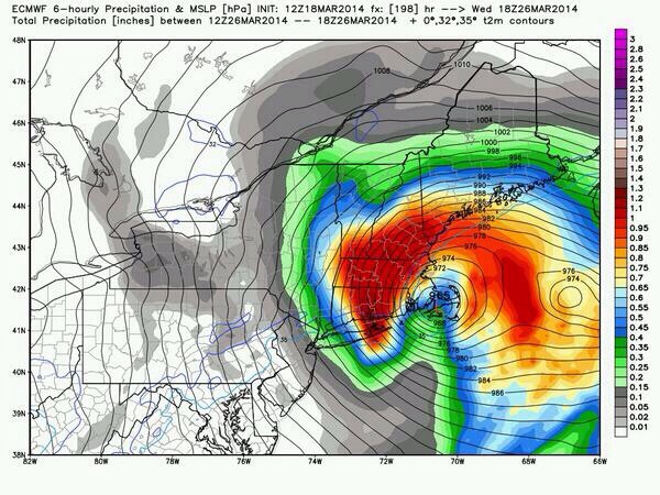
Thu: NW winds 25 to 30 kt with gusts up to 35 kt. Seas 8 to 13 ft. Light freezing spray. Snow.

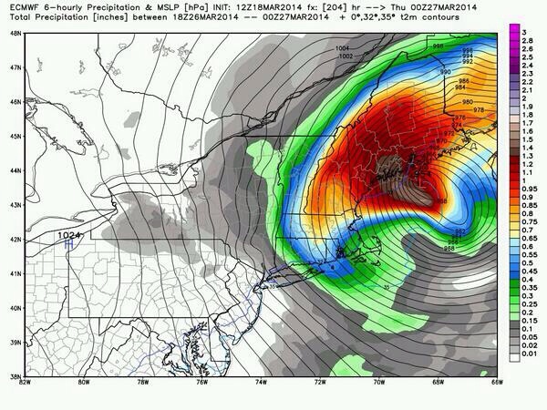
Thu Night: NW winds 25 to 30 kt…diminishing to 20 to 25 kt after midnight. Seas 6 to 9 ft. Light freezing spray. A chance of snow showers. Vsby 1 to 3 nm.
Sunrise 6:55AM Sunset 6:48PM
High Tide 9:58AM / 8.8 / 10:27PM / 8.3
Low Tide 3:35AM / 1.3 / 4:08PM / 0.8

Waxing gibbous
Visible: 91% ↑

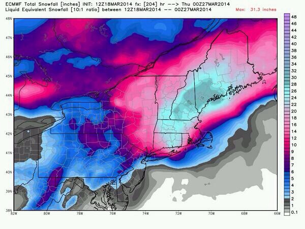
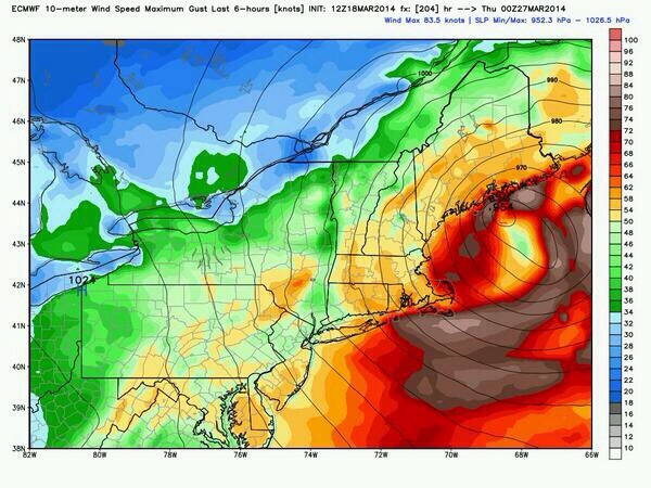
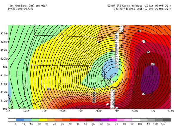
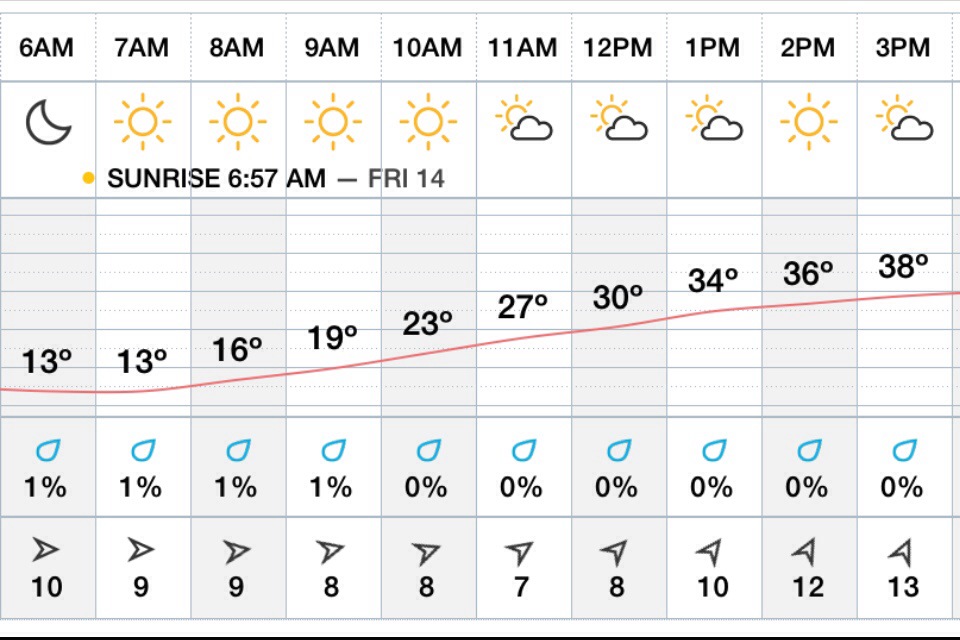
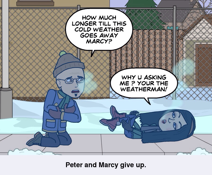
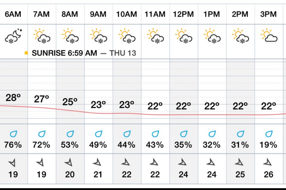
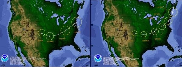
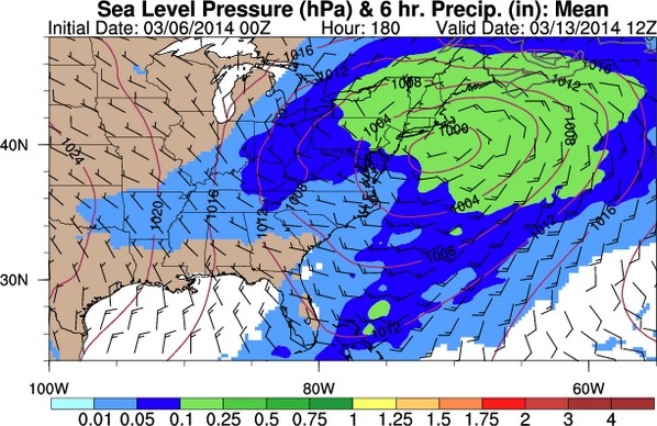
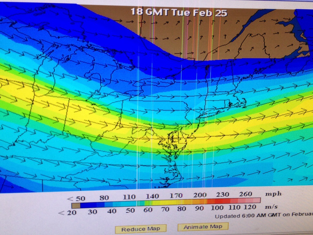
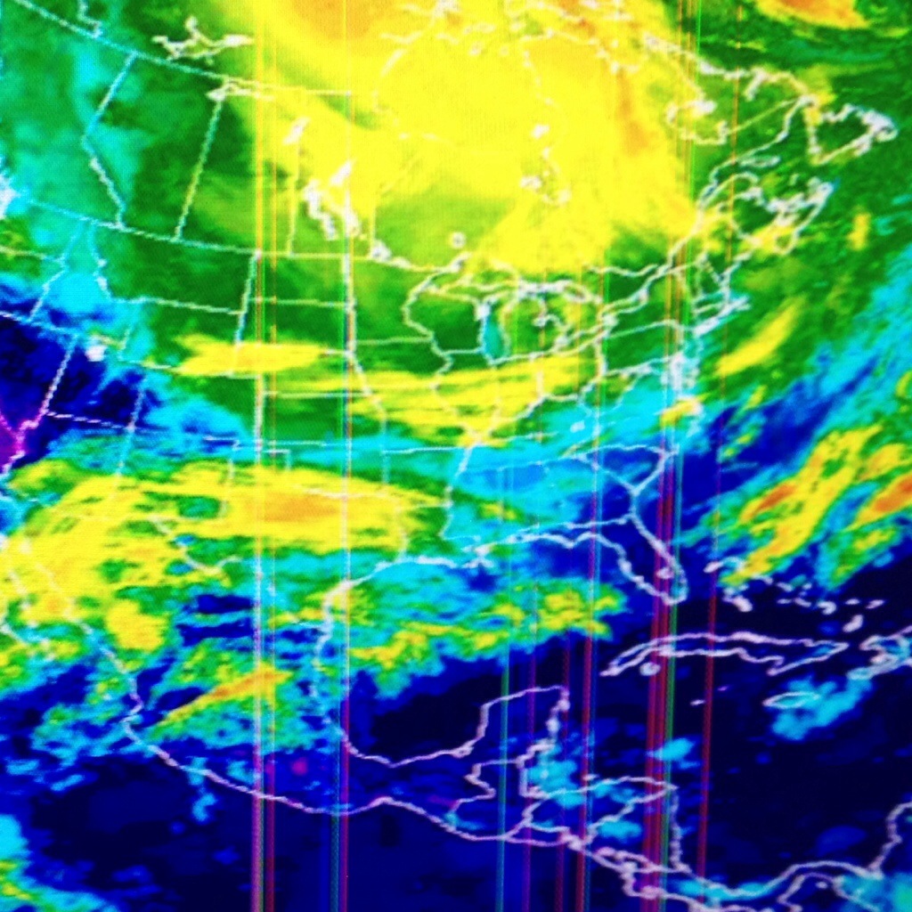
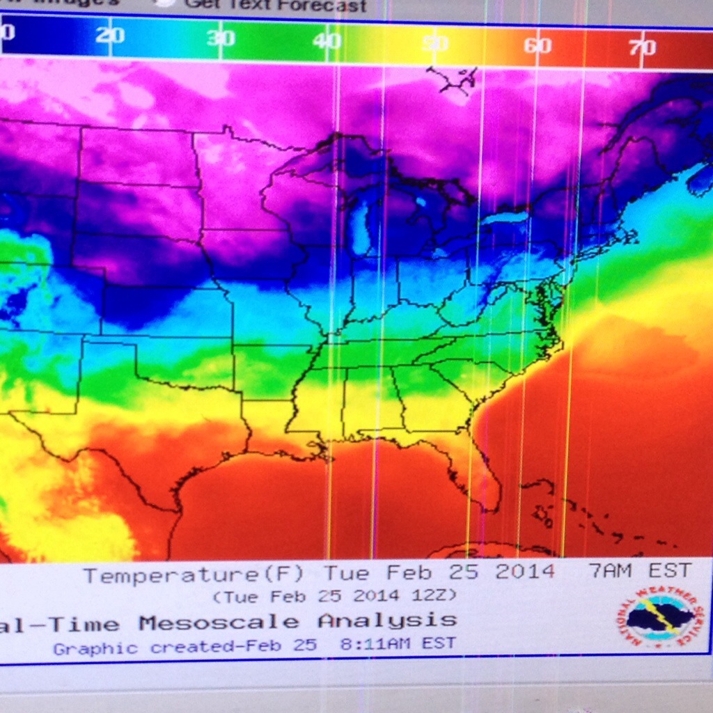
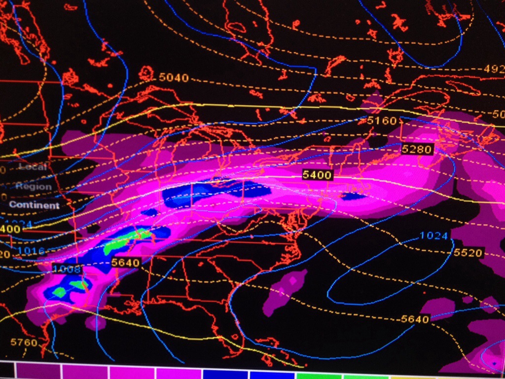
Flash Freeze conditions , with light to moderate snows… Am commute will have some icy roads, travel slow with caution .Temps will stay in 20’s all day . Windchill values in the single digits! Snows should diminish by noontime with left over snow showers possible ..winds the big story very gusty out of the north and north west 25-30 mph with a few gusts past 45mph! Thursday night FRIGID teens..gusty north west winds over 25mph…

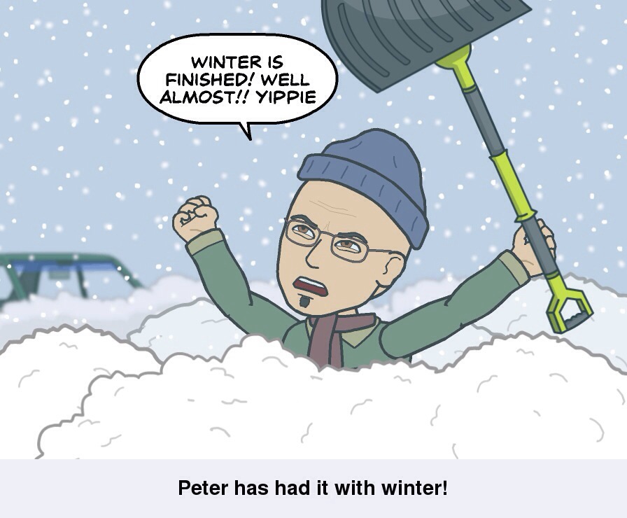
Total snow fall I’m expecting for Cape Ann is 2-3″..Not a lot but enough to make it very slippery and dangerous driving …drive slow be cautious ..
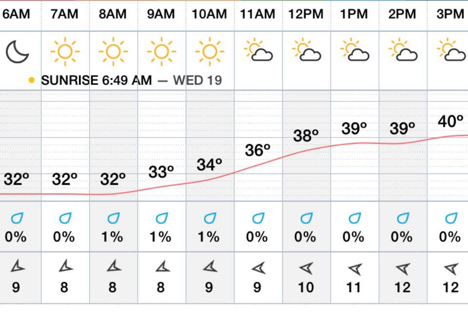
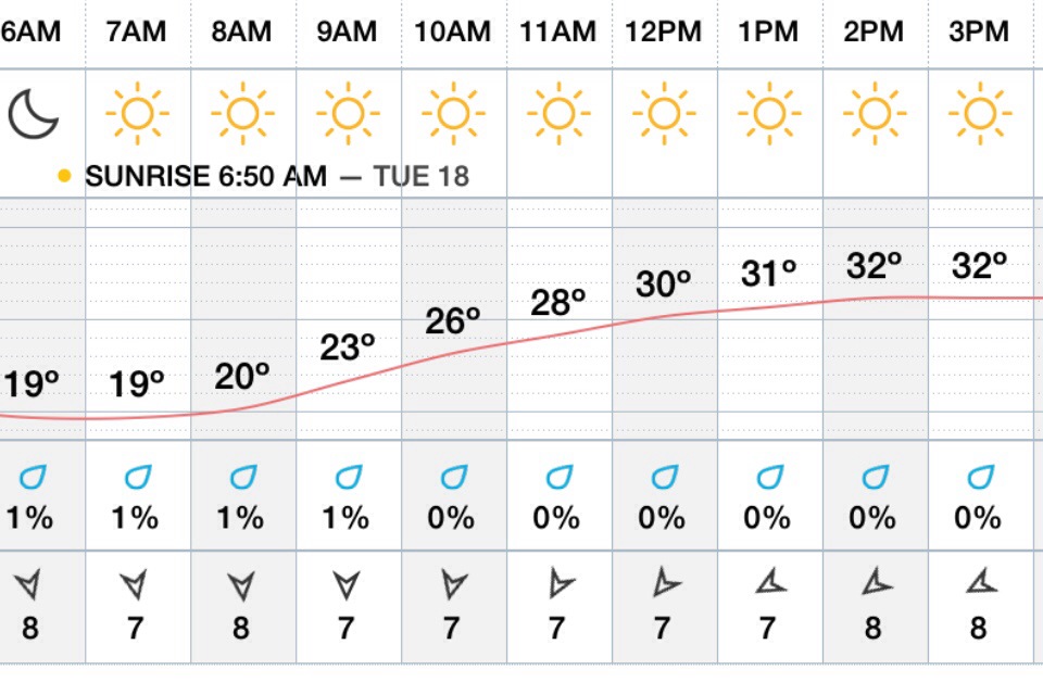
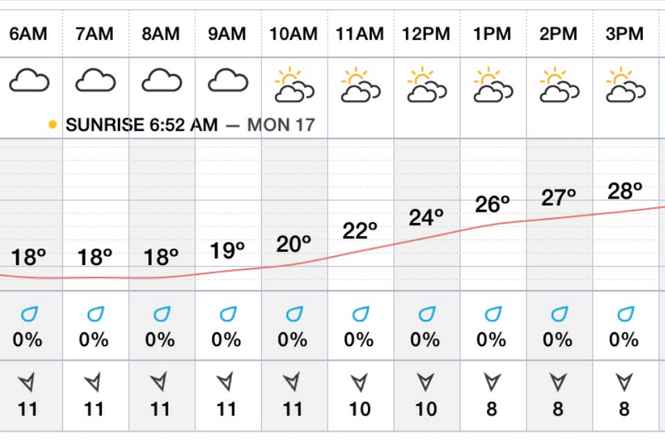
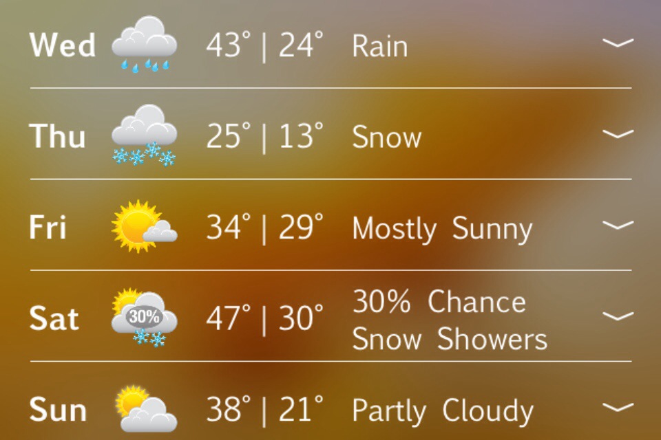
Hourly forecast ….

20140312-181323.jpg
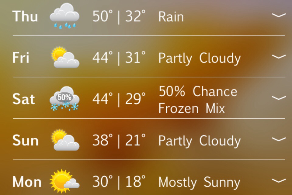
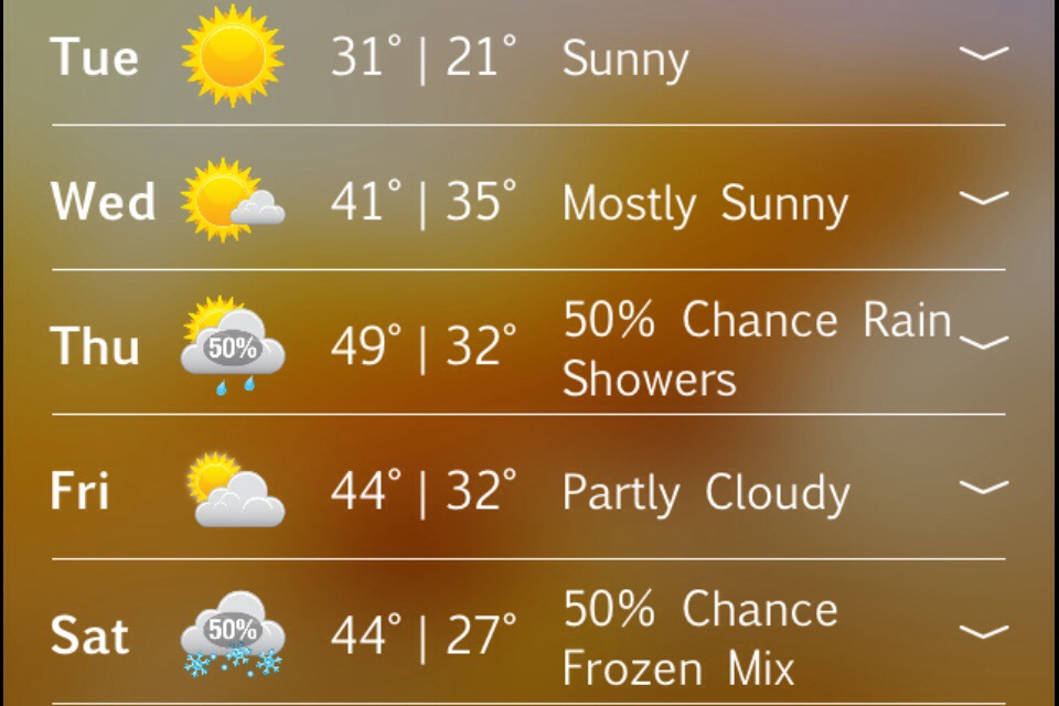
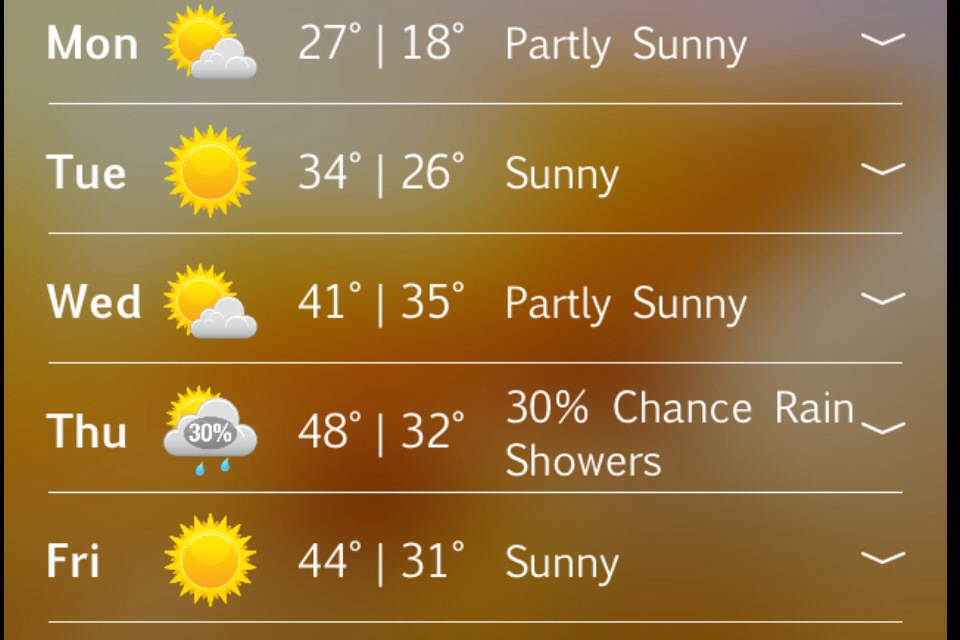
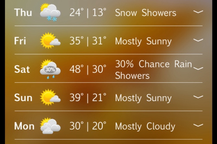
Extended Forecast ….

20140312-181700.jpg

20140312-182539.jpg

20140312-182554.jpg
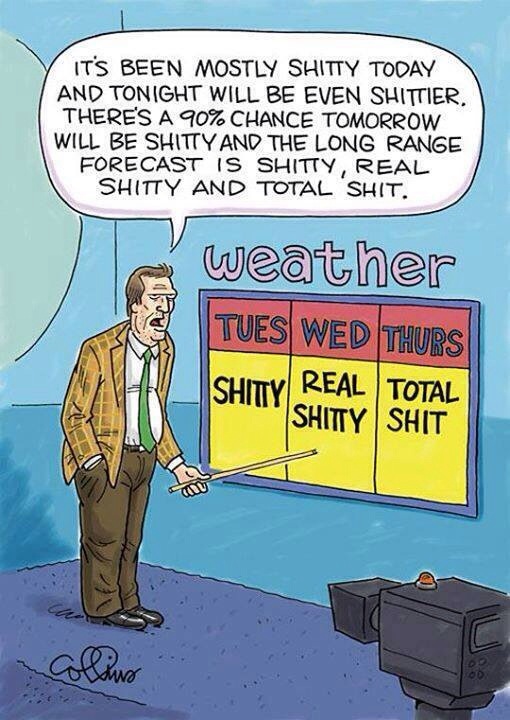
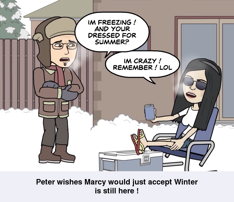
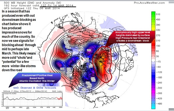
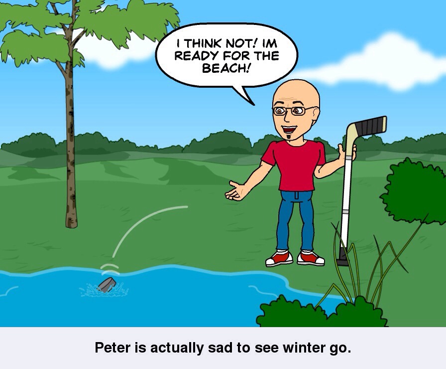
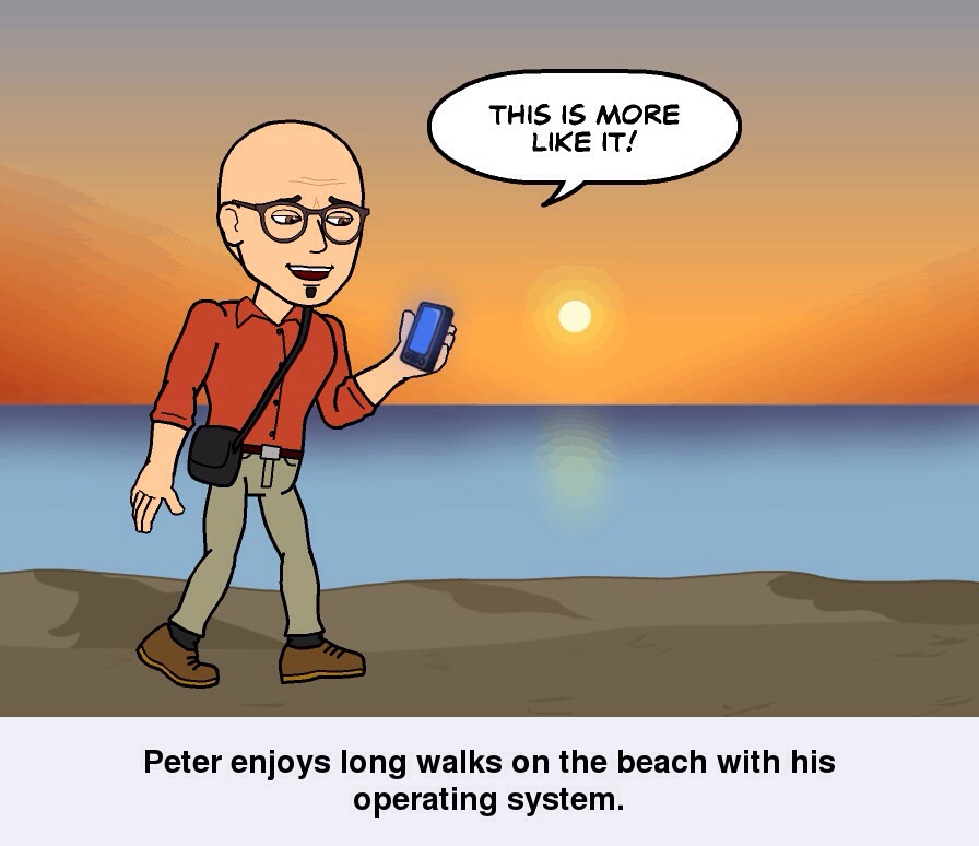
Next week looks wintery with cold bouts and snow ! Ugh. I’m trying people I really am . Soon enough will be at the beach baking in the sun 🙂
Thanks for viewing ..
Peter Lovasco
GMG
Weatherman

Wednesday March 12th , 2014 Cape Ann Forecast..

Marine Forecast …..
Gale Watch!
Wed: E winds around 5 kt…becoming SE in the afternoon. Seas around 2 ft. Rain likely.

Wed Night: E winds 5 to 10 kt…becoming NW 10 to 15 kt with gusts up to 25 kt after midnight. Seas 2 to 4 ft. Rain with freezing rain likely. Vsby 1 to 3 nm.
Sunrise 6:56AM Sunset 6:47PM
High Tide 9:09AM / 8.5 / 9:43PM / 8.0
Low Tide 2:44AM / 1.6 / 3:24PM / 1.0
Moon Waxing gibbous
Visible: 77% ↑…
Quick Storm Analysis ..

We have a storm coming for later this morning into Thursday morning. How ever it’s looking more wet then white .. Cloudy with light rain / snow early changing to a heavy rain after 1-2pm .. Highs 35-45 degrees with a increasing east wind 15-20mph .. Wednesday Night overcast rain heavy at times lows in the mid to upper 30’s . Winds east becoming north 20-25mph with a few gusts to 35mph … Late Wednesday night cold air drains down from Maine as our storm system heads into the Gulf Of Maine … Flash freeze possible Thursday am with rain changing over to snow .. Light accumulations possible on the order of 1-2″ maybe 3″ if were lucky . Temps falling through the 20’s don’t be surprised if we hover around 19 or 20 degrees at lunch time … Backlash snows end around midday or so then overcast / break in clouds to allow for a few sunny glimpse’s . Thursday night very cold teens / to lower 20’s gusty north west winds ..
Friday Sunny highs in the 30’s..
Saturday partly sunny in the upper 40’s..
Sunday mostly sunny 40..
Perhaps some storminess of sorts Monday / Tuesday .. But let’s get through this week first .. Thanks For viewing .
GMG
Weatherman
Peter Lovasco
Tracks…

20140311-102130.jpg

20140311-102148.jpg

20140311-102200.jpg

20140311-232326.jpg

Monday Evening Cape Ann Forecast . March 10th , 2014

Marine Forecast For Tuesday March 11th , 2014 ….
Tue: W winds 10 to 15 kt with gusts up to 20 kt. Seas 2 to 3 ft.

Tue Night: W winds 5 to 10 kt. Seas around 2 ft.
Sunrise 6:58AM Sunset 6:46PM
High Tide 8:14AM / 8.4 / 8:53PM 7.7
Low Tide 1:47AM / 1.7 / 2:33 1.2 /
Moon / Waxing gibbous visible: 69%

Spring Scale 1-10 for Tuesday
8…….Water temp 38 Degrees …

Video Forecast …..

20140310-152023.jpg

20140310-152036.jpg

Friday Evening / Weekend Forecast March 7th , 2014 Cape Ann..

Marine Forecast Friday Night Through Sunday Night….
Tonight: E winds around 5 kt…becoming N after midnight. Seas 2 to 3 ft.

Sat: NW winds 5 to 10 kt. Seas 2 to 4 ft.

Sat Night: NW winds around 10 kt. Seas 2 to 4 ft.

Sun: NW winds 10 to 15 kt with gusts up to 20 kt. Seas 2 to 4 ft.

Sun Night: NW winds 10 to 15 kt with gusts up to 20 kt… Becoming W 5 to 10 kt after midnight. Seas 2 to 4 ft. A chance of snow showers. Vsby 1 to 3 nm.

Video Weekend Forecast

Don’t Forget “Spring Ahead” Saturday Night 1HR!!!

20140307-155243.jpg

20140307-155310.jpg

20140307-155458.jpg
Possible Storminess Wednesday through Thursday Night ! Long Duration event …

20140307-155618.jpg

Friday March 7th , 2014 Cape Ann Weather …

Marine Forecast….
Fri: SE winds 5 to 10 kt. Seas around 2 ft.

Fri Night: E winds around 5 kt…becoming N around 5 kt after midnight. Seas around 2 ft.

Video Forecast …..

20140306-171559.jpg

20140306-171640.jpg

20140306-171728.jpg
This concerns me!

Thursday March 6th , 2014 Cape Ann Weather..

Marine Forecast
Thu: N winds 10 to 15 kt with gusts up to 20 kt…becoming NE 5 to 10 kt in the afternoon. Seas 2 to 4 ft.

Thu Night: SE winds around 5 kt. Seas 2 to 3 ft.

It’s gonna be another cold day with clouds and sun temps in the 20’s struggling to hit 30.. Winds onshore from the north northeast at 10-15 mph with a few higher gusts . As far as ocean effect snow bands go will just have to wait and see if they materialize or not .. Very cold air passing over the ocean waters for this time of year .. Very hard to predict these events but not ruling it out . Tonight very cold lows teens to 20’s light North east winds becoming south east 10-15 mph…
Friday sun / clouds we warm up a bit highs around 40.
Saturday lower 40’s dry weather continues with mostly sunny skies ..
Sunday 44

Late next week watching potential storminess conditions around Wednesday / Thursday time period…
Have a great day … Thanks for reading …
Peter Lovasco
GMG
Weatherman

20140306-022329.jpg

20140306-022345.jpg

20140306-022412.jpg

Wednesday March 5th 2014 Hump Day Cape Ann Forecast …

Marine Forecast …
Wed: N winds 10 to 15 kt with gusts up to 20 kt. Seas 3 to 5 ft. A chance of snow showers.

Wed Night: N winds 15 to 20 kt with gusts up to 25 kt. Seas 4 to 7 ft. Light freezing spray. A chance of snow showers.

Hey Happy “Hump Day” folks .. Snow showers or flurries in the morning with light northerly to northeasterly winds 5-10mph .. High around 30 .. Tonight snow showers / flurries end in the evening hours . Lows in the 20’s shore teens interior …
Thursday mostly sunny highs 25-33 degrees . Coolest interior . Light winds 10-15mph.. Thursday night partly cloudy lows around 25..

Today snow showers or flurries are caused by onshore fetch of northerly and northeasterly winds ..water temps in the 30’s with highs in the 20’s to lower 30’s cause a mix of warm and cold temps off Atlantic Ocean in return gives us the light snows . How ever one thing that’s bugging me is that the the forcing for ascent is pretty weak and instability isn’t all that great either . But given past Experience and looking over past history data , I can’t rule out 2-3″ of ocean effect snows if all comes into exact formation … Otherwise it’s just nuisance values . So I’ll be keeping an eye to see if any banding develops .. Certainly worth watching as these can creep up on us with little or no warning at all..
Extended look ahead 40’s return late week , with a few storm chances late next week . One which could be snow . But that’s way way off for now ! Have a great day .. Thanks again for viewing 🙂
Peter Lovasco
GMG
Weatherman

20140304-201818.jpg

20140304-201830.jpg

20140304-201841.jpg

Tuesday March 4th , 2014 Cape Ann Weather..

Marine Forecast…
Tue: NW winds 5 to 10 kt…becoming SW in the afternoon. Seas 2 to 4 ft.

Tue Night: SW winds around 5 kt…becoming NW after midnight. Seas 2 to 3 ft.
Tuesday Mostly sunny with a few fair weather clouds warmer temps around 30 degrees … With a light northwest wind around 10 mph becoming southwest late in the day .. Clouds increase late day with dry conditions ..
Tuesday night mostly cloudy with a low of 25 degrees.. Light north winds 5-10 mph .. Could see sum ocean effect snow showers or flurries well after midnight ..30% chance…
Wednesday cloudy with a chance of snow showers with a north to northeast wind around 10mph . High 30 degrees .. Snow showers possible Wednesday night with northeast winds 15-20 mph possible higher gusts.. Little if any accumulations… Lows in the 20’s..
Thursday / Friday / Saturday extended outlook mostly cloudy highs in 30’s lows in the 20’s . Lower 40’s Saturday ..with mostly sunny skies …
It seems as if winter is finally loosing it’s grip on Cape Ann … Temps rebound to 40’s this weekend with mostly sunny skies .. Watching a coastal storm for late weekend , at this time it appears the high pressure will protect us from any impacts .. But it’s 4-5 days out so I’ll have more on that potential later in the week.. Have a terrific Tuesday and thanks for viewing ..
Peter Lovasco
GMG
Weatherman

20140303-204537.jpg

20140303-204605.jpg

20140303-225752.jpg

Monday March 3rd 2014 Cape Ann Weather..

Marine Forecast …
Small Craft Advisory !
Mon: NW winds 15 to 20 kt with gusts up to 25 kt. Seas 3 to 5 ft. Light freezing spray likely. A chance of snow. Vsby 1 to 3 nm.

Mon Night: NW winds 15 to 20 kt…diminishing to 10 to 15 kt after midnight. Seas 2 to 4 ft.
Monday overcast few flurries or snow showers first thing in the morning possible highs in the low to mid 20’s. Midday sunny breaks and sunshine . North wind 10-20mph… Monday Night very cold low around 10 above !
Tuesday through Friday sun / clouds with temps in the 20’s to lower 40’s Friday . Few bouts of snow showers possible as well .. Lows in the teens to mid 20’s late week.. Ok enjoy you’re Monday … Thanks for viewing …
Peter Lovasco
GMG
Weatherman

20140302-171450.jpg

20140302-171520.jpg

20140302-171544.jpg

20140302-171608.jpg

Saturday March 1st 2014 Cape Ann Weather …

Marine Forecast ……
Small Craft Advisory …
Today: S winds 5 to 10 kt…increasing to 10 to 15 kt this afternoon. Gusts up to 25 kt late. Seas 2 to 3 ft.

Tonight: SW winds 10 to 15 kt with gusts up to 25 kt. Seas 2 to 3 ft.

Welcome to March 🙂 today looking at mostly sunny skies highs in the 30’s. Winds west SW 10-20 mph … Tonight cold lows around 30 degrees …
Sunday cloudy with light snow or snow showers late morning through Monday am .. Temps in the 20’s to low 30’s….
There ya go folks sorry feeling blah blah today . Hope to feel better before the snow moves in . I’m forecasting dusting to 2″ for Cape Ann at this time … Thanks for viewing …
Peter Lovasco
GMG
Weatherman

20140301-064031.jpg

20140301-064044.jpg

RoboCop Appears to be Thawing – Will he get free in time?

Caught in a wicked storm RoboCop had frozen solid within the ice. Now he could feel the sun and his energy was recharging. Soon he will break free to wreak  justice on the not so innocent…His prayers have been answered.  Little does he know another storm is already fast approaching which could prolong his confinement!!

Can you see RoboCop?

Friday February 28th 2014 Cape Ann Weather…

Marine Forecast ….
Gale Warning through early morning hours…. Then Small Craft Advisory takes over…
Fri: W winds 15 to 20 kt with gusts up to 35 knots .Diminishing to 10 to 15 kt with gusts up to 20 kt in the afternoon. Seas 2 to 4 ft.

Fri Night: W winds 5 to 10 kt. Seas around 2 ft.

Ok to be honest with you this cold weather is driving me nuts! But it is what it is . And will get through it! So looking ahead to today sun / clouds can’t rule out a snow shower or flurry cold temps once again highs generally in the low to mid 20’s with a gusty west wind 15-20 mph .. Windchill values will feel like it’s the single digits … Friday night yup u guessed it FRIGID again lows around 10 above with a light and diminishing wind..
Saturday clouds / sun a tad warmer 30-35 degrees with a south wind 10-15 mph and gusts to 25mph possible .
Saturday night Increasing clouds late possible snow showers after midnight lows Around 26-30 degrees … Sunday overcast chance of light snow showers 35 degrees …
Sunday night / Monday watching potential storm ….

Now to Sunday night / Monday …A stationary front will be just off the south coast of New England . Waves of low pressure will ride along the front just south of us , keeping us in the cold potentially snowy side of things . A few models want to give us 2-6″ of snow .. It’s still to early to determine the exact impacts will experience Sunday Night / Monday .. There is still strong signaling that the storm could be even more suppressed to our south missing storm completely . So I’ll have a lot to iron out over the next 36-48 hrs .. Stay tuned . Regarding the snow , it will still stay rather cold through all of next week with a slight moderation in temps possible next Saturday . But by then we may be looking at another wintry bout with Mother Nature .. So we can’t win here or even catch a break ! Have a great Friday everyone .. And Happy TGIF to all of U… 🙂 thanks for reading …
Peter Lovasco
GMG
Weatherman

20140227-191602.jpg

20140227-191616.jpg

Thursday February 27th 2014 Cape Ann Weather…

Marine Forecast…
Small Craft Advisory!
Gale Watch!
Thu: SW winds 5 to 10 kt…increasing to 15 to 20 kt with gusts up to 30 kt in the afternoon. Seas 2 to 3 ft. Scattered snow showers.

Thu Night: W winds 15 to 20 kt…increasing to 20 to 25 kt after midnight. Gusts up to 35 kt. Seas 2 to 4 ft. Freezing spray.

Video Forecast…..

Thanks for viewing 🙂
Peter Lovasco
GMG
Weatherman

20140226-201508.jpg

20140226-201523.jpg

20140226-201535.jpg

Wednesday February 26th 2014 Cape Ann Forecast..

Marine Forecast…
Wed: W winds 10 to 15 kt. Gusts up to 25 kt in the afternoon. Seas 2 to 3 ft. Snow showers likely.

Wed Night: NW winds 15 to 20 kt with gusts up to 25 kt… Becoming W 10 to 15 kt after midnight. Seas 2 to 3 ft.

Video Forecast…

Wanted to share a few Maps with u as well… Enjoy …

20140225-194535.jpg
Our Jet Stream … Storm track …

20140225-194642.jpg
Infrared Satellite .. So far so good…

20140225-194811.jpg
Temperature Map .. Shows us in the dark blue / purple very cold conditions ..

20140225-194952.jpg
Model Map For Sunday Night / Monday .. Possible Snow Event!!! Say it isn’t so!!

20140225-195118.jpg

20140225-195133.jpg

Tuesday February 25th 2014 Cape Ann Forecast..

Marine Forecast…
SMALL CRAFT ADVISORY!!!
Tue: W winds 15 to 20 kt with gusts up to 25 kt. Seas 2 to 3 ft.

Tue Night: W winds 10 to 15 kt with gusts up to 25 kt. Seas 2 to 3 ft.

Well not much to talk about , we are definitely locked in on a colder pattern . With mostly dry conditions , very cold Tuesday through Monday of next week temps in the 20’s lows single digits to teens with windchill values in the negative range of -10 to + 10 above…. Clouds at times with a few snow showers or flurries … That’s really about it .. Monday maybe a more significant chance for snows , but that’s 5-6 days out plenty of room for changes… I can’t say I see spring around the corner … It’s def delayed.. So keep those furnaces going and windows shut. Have a great Tuesday .. And thanks for reading …
Peter Lovasco
GMG
Weatherman

20140224-201014.jpg

20140224-201030.jpg

20140224-201043.jpg