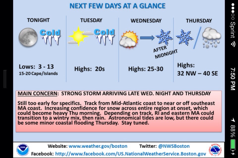
Friday February 21st 2014 Cape Ann Forecast…

Happy TGIF everyone !!
Marine Forecast …
•••SMALL CRAFT ADVISORY•••
Fri: SE winds 15 to 20 kt with gusts up to 30 kt. Seas 3 to 5 ft. Areas of fog. Rain. Vsby 1 to 3 nm.

Fri Night: SW winds 15 to 20 kt…diminishing to 10 to 15 kt after midnight. Gusts up to 25 kt. Seas 2 to 4 ft. Patchy fog. Rain. Vsby 1 to 3 nm.

Here’s your Friday Video Forecast..

This is Funny but hopefully unlikely !!

20140220-204829.jpg
Euro snow outlook for next week into next weekend ! I’m thinking the Euro has been brainwashed from the American GFS Model…

20140220-205015.jpg

20140220-205028.jpg

Thursday February 20th 2014 Cape Ann Forecast..

Marine Forecast …
Thu: W winds 10 to 15 kt with gusts up to 20 kt… Becoming SW 5 to 10 kt in the afternoon. Seas 2 to 4 ft.

Thu Night: SE winds 5 to 10 kt. Seas around 2 ft. Rain likely. Vsby 1 to 3 nm.

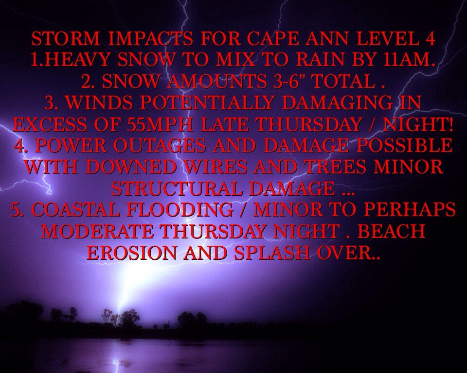
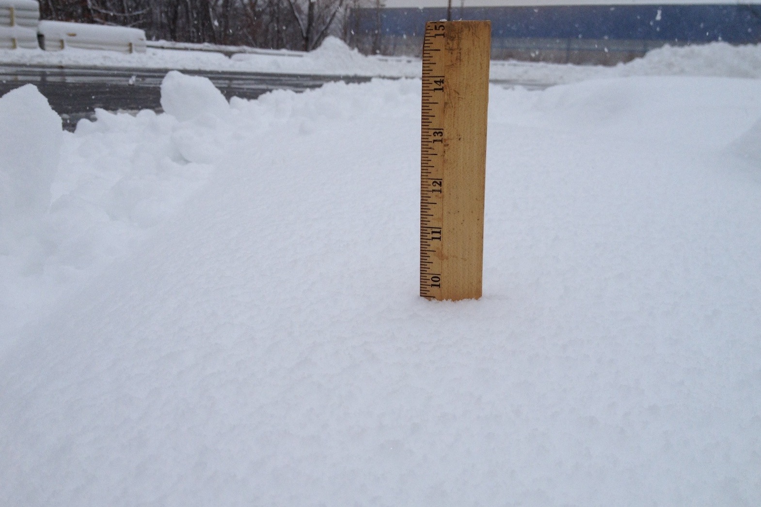
Today sunny mild 45-50 degrees!!!! Yes mild for once , so get out and enjoy because it’s not gonna last very long .. West winds 10-15mph.. Thursday night a chance of rain well after midnight , otherwise mostly cloudy with a low around 36-40 degrees.. Patchy fog also possible …
Coming up for Friday very mild temps near 50 degrees with periods of showers possible embedded thunderstorms… South east to southwest winds 10-20mph …Friday night showers ending by early evening lows in the 30’s..
Your weekend outlook
Saturday mostly sunny highs in the mid to upper 40’s lows upper 20’s to lower 30’s..
Sunday sunny highs around 40 ..

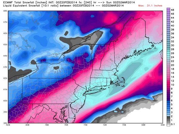
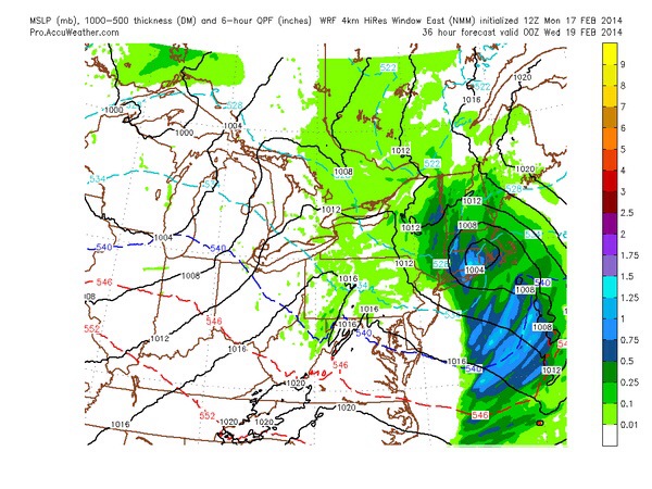
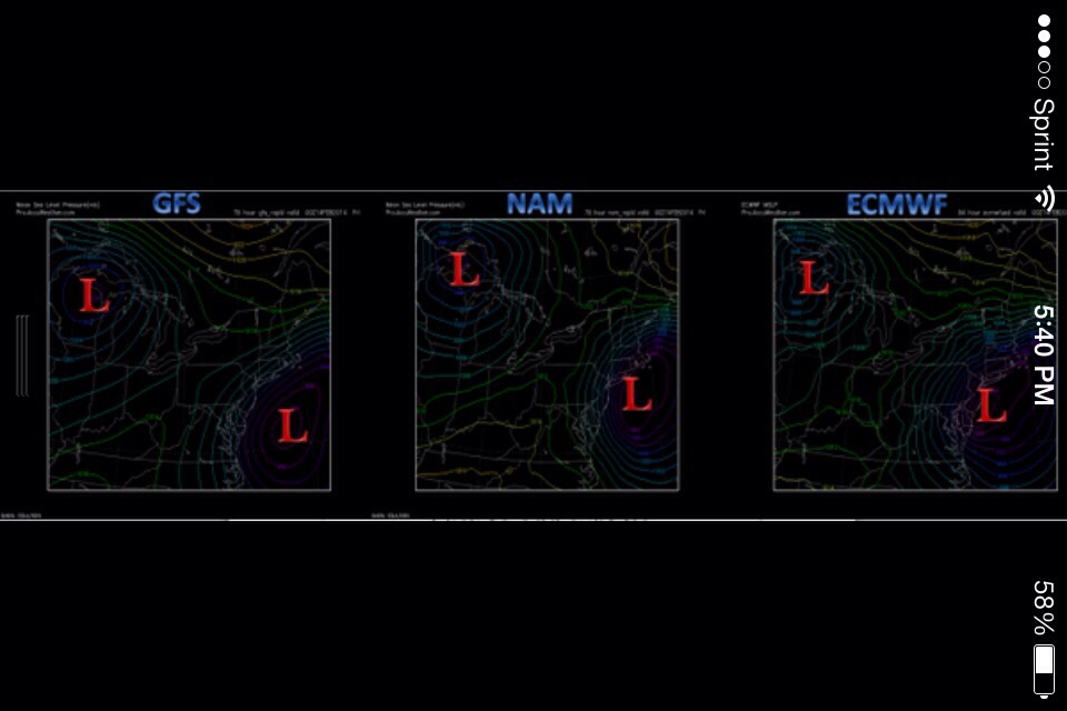
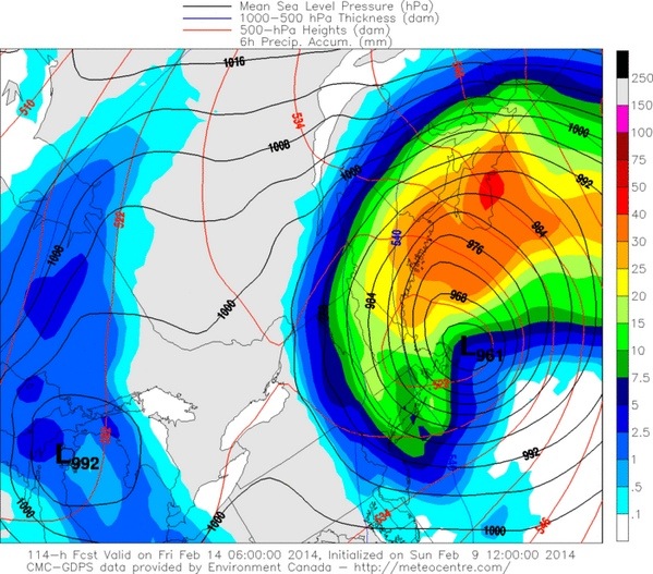
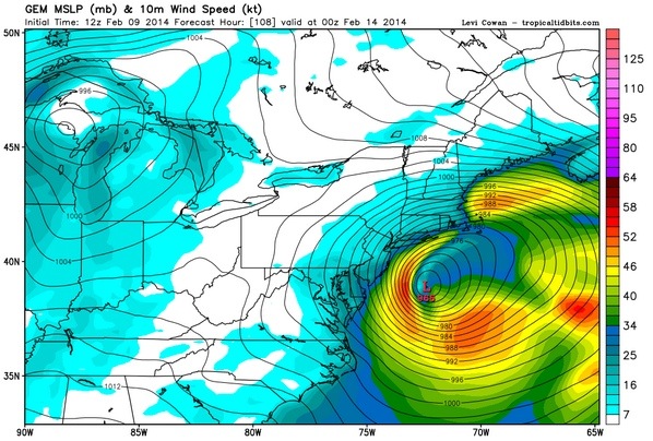
Ok so we get this brief mild spell followed by another Polar Arctic Vortex , and extreme storm track . It seems as if winter keeps playing the broken record over and over .. One thing will need to watch besides the cold air is plenty of opportunities for snowstorms .. And being this far ahead into winter , we usually get our biggest storms . So no panic , but be ready for rapidly changing weather conditions … Here’s a look at what’s in store for the next two weeks …..

20140219-202652.jpg
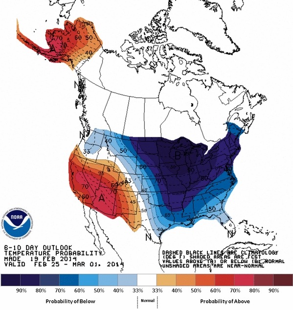
Yup frigid temps ! And it could shunt the storm track a bit further south of New England ! One will have to watch …I know your all ready for Spring as I am .. So let’s be patient and hope for the best …:) Thanks for viewing ..
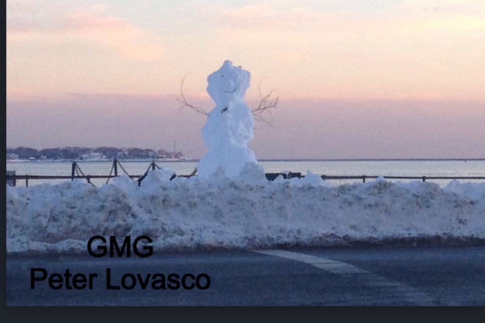
Peter Lovasco
GMG
Weatherman

20140219-203703.jpg

20140219-203715.jpg

Wednesday February 19th 2014 Cape Ann Forecast…

Marine Forecast….
Wed: SW winds 5 to 10 kt…becoming SE with gusts up to 20 kt in the afternoon. Seas 2 to 4 ft. Rain with a chance of snow. Vsby 1 to 3 nm.

Wed Night: W winds 15 to 20 kt with gusts up to 25 kt. Seas 2 to 4 ft. A chance of rain. Vsby 1 to 3 nm.

Today sun / clouds with mostly cloudy skies late morning highs around 35-42 degrees .. Rain late possibly mixed with snow but mostly a wet afternoon .. Winds SW 10-15 mph becoming SE 10-20 mph late …
Wednesday night rain mixing with wet snow flakes .. No accumulations .. Rain ends by 10pm or so , lows around 30-35 degrees . West winds 10-15mph
Thursday Sunny with a few clouds temps in the 40’s..
Friday periods of rain very mild temps in low 50’s .
Saturday Sunny 40’s Sunday chance of rain low 40s . Night time lows 30’s
Colder trend next week with a few chances at snow or mixed rain and snow … Thanks for reading .. Happy Hump Day ….

20140218-223603.jpg

20140218-223619.jpg
Model Map of our rain late Wednesday ..

20140218-224957.jpg
Low pressure moving across our area .

20140218-225103.jpg

Tuesday February 18th 2014 Cape Ann Weather Update !

As of last nights forecast , this event for midday into early evening looks very minor with nuisance snows 1-2″ inches for our viewing area .. Storm is weak and most moisture remains to our North ! Se winds will limit snow amounts . And make it tough to stick on roadways . Even a mix or change to rain is possible , so again no big event ! More weather on Wednesday .. Have a great Tuesday … Thanks for reading …
Peter Lovasco
GMG
Weatherman

20140218-064055.jpg

•••WINTER WEATHER ADVISORY••• Monday Night February 17th 2014 Cape Ann Weather..

The NWS in Taunton has issued a Winter Weather Advisory for our area from 7am Tuesday to 7pm .. Hazard types heavy snow at times with reduced Visibilities to a half mile or less.. Calling for 3-5″ for Cape Ann with east winds 10-20 mph . Driving conditions expected to get treacherous after 1pm.

Ok that’s from the NWS .. My thoughts really are as follows : First off will have a east or south east wind that’s a warming wind direction that would make for a very wet wet snow ! Very hard to accumulate on roadways with east / south east winds and temps in mid 30’s.. With that being said it’s not impossible but unlikely .. I’m calling for 1-2″ perhaps 3″ worst case scenario . It’s also possible we mix or change to rain … Nothing to panic over / no strong winds or freeze ups .. Minor to very minor event .. West of Cape Ann say Beverly or Salem better chance at the 5″ amounts further away from the marine influence …
After this minor event we warm up into the upper 30’s perhaps 40’s with rains on Friday … Weekend looking good at this time but that could change .. Back to winter next Monday cold returns and train of snow storms as well .. Have a great Monday night ! See ya sum time on Tuesday … Thanks for reading …
MARINE FORECAST
SMALL CRAFT ADVISORY
Tue: SE winds 10 to 15 kt…becoming E 15 to 20 kt in the afternoon. Gusts up to 25 kt. Seas 2 to 4 ft. Snow. Vsby 1 to 3 nm.

Tue Night: W winds 15 to 20 kt with gusts up to 25 kt. Seas 3 to 5 ft. A chance of snow. Vsby 1 to 3 nm.

Peter Lovasco
GMG
Weatherman

20140217-162821.jpg

20140217-162840.jpg

20140217-163340.jpg

20140217-163357.jpg

Storm Coverage From Last Night .. February 16th 2014 Cape Ann Weather…

Well it was nice to hang with Christina Hager WBZ and Crew down Good Harbor Beach Last Night… Even if the storm didn’t perform as projected .
Guess where lucky Cape Ann that the storm was further south . Mother Nature really Is really “Fickle” some times and brings surprises .. This surprise was fortunate for us missing the brunt of the storm …On to the. Next potential for Tuesday !

Today sun and clouds temps in the 20’s to lower 30’s with a busy west north west wind at times gusting to 25-35 mph into the afternoon.. Increasing clouds late few flurries or snow showers can’t be ruled out .
Tonight mostly cloudy skies with temps in the teens to around 20 degrees…
Watching Tuesday for potential coastal coastal low with more snow or rain / snow mix temps in 30’s….

Marine Forecast Gale Warning till early afternoon…This Afternoon: W winds 25 to 30 kt…diminishing to 20 to 25 kt. Seas 8 to 13 ft. Light freezing spray early.

Tonight: NW winds 20 to 25 kt. Seas 5 to 8 ft. Light freezing spray.

20140216-101438.jpg

20140216-101454.jpg

BLIZZARD UPDATE! 8:30PM FEBRUARY 15TH 2014

Well u can’t win um all , sure I’ll take criticism .. I busted .. But it’s better to be safe then sorry .. Amounts down to 6″ as well as winds down … Power outages very very scattered from weight of pasting snow and winds 25-35 few gusts to 40-45mph from NNE!
So we shot this footage earlier this evening so prob disclaim it , but still fun to view !! Thanks for viewing the kind compliments and be safe …
Peter Lovasco
GMG
Weatherman

BREAKING BLIZZARD UPDATE FEBRUARY 15TH 2014

2:00PM UPDATE!!!
TRAVEL NOT RECOMMENDED AFTER 5-6PM!!!!!
VERY POTENT QUICK INTENSE HITTING BLIZZARD 6PM -2AM BRUNT
SNOW FALL RATES 2-4″ PER HOUR
AMOUNTS IN QUESTION .
VERY VERY SIGNIFICANT DAMAGING WIND EVENT! TREES / WIRES / STRUCTURAL DAMAGE TO HOMES POSSIBLE… WINDS GUSTING TO HURRICANE FORCE!
PLEASE STAY HOME BE SAFE AND DO NOT TRAVEL IN THIS BLIZZARD!!!!
THIS IS A VERY DANGEROUS STORM!!!!

BLIZZARD WARNING !!!! SAT-SUN AM FEB 15th CAPE ANN

BLIZZARD WARNING!!!!!
8-10″ Heavy Snow
Damaging Winds Excess of 60mph!
Coastal Flooding Minor!
Start Time 2-4 PM ..
End Time 2-6AM SUNDAY!

Mariners Forecast !
DONT GO OUT!!!!
Winds NE 30-50 Knots Sustained
Gusts past 70 Knots ! Seas building 17-25 FT!

Synopsis …. Bombing storm off ACK later today and tonight will bring in heavy bands of Snow and Wind …
Travel not recommend after 6pm ! As high winds / and Snow will make for 0 visibility at times … Snow will accumulate 8-10″ maybe higher ! Sum models put out more QPF / while others less.. Winds pick up 25-35 from east late day veering north east 35-45 sustained tonight gusts over 60mph!
Storm warning at the Coast !
Hurricane Force wind Warning 30 miles off shore ! Track crucial if 30 miles further west then Hurricane Conditions to the shore …power outages likely ESP CC / South Shore .. Although Cape Ann Will have plenty as well I’m sure .. K more later … Maybe a live Report later tonight .. Please if u don’t have to go out tonight Don’t !!! Thank u for reading …
Peter Lovasco
GMG
Weatherman …

20140215-065320.jpg

BREAKING!!!!!!! WEATHER!!!!!

••••BLIZZARD WATCH•••••••
More forecast to come later….
ESSEX COUNTY!!!!
PJL
GMG
WEATHERMAN

SEVERE WEATHER LIVE UPDATE FEB 14th THURSDAY NIGHT!!

Live From Bass Rocks…
Damaging Winds In Excess of 65mph!!!
Backlash a Big Question Mark!!!
Storm Continues next Several Hours.
Power Outages Likely … Sorry I’ve been under the weather today stuck at home sick in bed .. But I ran out with Marcy to get this footage for u.. Enjoy and I’m sure you’ll be shocked as well..
Thanks for viewing .
Peter&Marcy
GMG
G.E.T. W.E.T.

Wednesday Feb 12th 2014 Cape Ann Forecast..

Marine Forecast …
Wed: N winds 10 to 15 kt with gusts up to 20 kt…becoming NE around 5 kt in the afternoon. Seas around 2 ft.

Wed Night: SE winds 5 to 10 kt. Seas 1 foot or less.

Today mostly sunny cold after morning lows in single digits temps will only rise to mid to upper 20’s with north northwest winds 10-15 mph..
Wednesday night increasing clouds lows around 20-25 degrees .. Late night snows break out well after midnight .. Thursday heavy snow in the morning going over to sleet / freezing rain then rain by 11am to noontime ..highs in the upper 30’s with se winds 20-25 mph increasing to 25-35mph by late Thursday afternoon and evening .. Thursday night heavy rain early with damaging winds possible , gusting over 55mph ! Winds turn north northeast late evening rain changes back to snow .. 3-6″ total ..
Over view / LP tracks from OBX to just SE of ACK , this track will likely induce Warmer air to come from off the ocean with water temps in 30’s . How ever I’m not sold on this and think it’s possible as LP intensifies off ACK it creates “DYNAMIC COOLING” which would crash the temps with all heights above us creating a quicker transition back to snow. Something to watch for Thursday . Also watch for damaging wind potential .. More later today with special video update on impending storm .. Thank u for reading and viewing …
Peter Lovasco
GMG
Weatherman

20140211-202550.jpg

20140211-202614.jpg

20140211-202626.jpg

Tuesday February 11th 2014 Cape Ann Forecast..

Marine Forecast…
Tue: NW winds 10 to 15 kt with gusts up to 20 kt. Seas around 2 ft.

Tue Night: NW winds 10 to 15 kt. Gusts up to 20 kt in the evening. Seas around 2 ft.

Lots to talk about in this video Forecast regarding Wednesday night / Thursday Storm Threat… Lots of uncertainty …?????

Model images of impending Storm late week… One thing to remember nothing is “LOCKED” in stone… Models all over the place … I do believe will see a trend towards a Colder situation with very intense “Bomb” SE of ACK!

20140210-195408.jpg

20140210-195424.jpg

20140210-195441.jpg

20140210-195500.jpg

20140210-195516.jpg

20140210-195530.jpg

Monday February 10th 2014 Cape Ann Forecast..

Marine Forecast
Mon: NW winds 10 to 15 kt with gusts up to 20 kt. Seas 2 to 3 ft.

Mon Night: NW winds 10 to 15 kt. Seas 2 to 3 ft.

This morning few flurries / clouds then sunny conditions temps 24-31 degrees with north west winds 10-15 mph . Monday Night cold temps crashing into the teens north west winds 10-15mph.. Tuesday Sunny 20’s lower 30’s / Wednesday fair / Thursday watching potential storm and track uncertain as well as mix / rain / snow lines .. Stay tuned …. Thanks For Reading . Have a great Monday .
Peter Lovasco
GMG
Weatherman

20140209-185829.jpg

20140209-185849.jpg

20140209-185906.jpg

Saturday February 8th 2014 Cape Ann Forecast..

Marine Forecast…
Sat: W winds 10 to 15 kt…diminishing to 5 to 10 kt in the afternoon. Gusts up to 20 kt. Seas 2 to 3 ft.

Sat Night: NW winds 5 to 10 kt. Seas around 2 ft.

Saturday sun early clouds increase late highs around 30-34 degrees .. West winds 10-15 mph .. Saturday night cloudy temps dropping into the teens with north west winds around 10mph..
Sunday cloudy with periods of light snow or snow showers high near 30 winds light onshore . 1-3″ possible if enough moisture can back into the coast from offshore.. Nothing big more of a nuisance snow , but could make for slippery and icy road conditions and travel . So keep that In mind just in case .. Monday snow showers continue for Cape Ann in the morning hours , again highs near 30 or so degrees….
Possible late week storm Thursday / Friday . Much to early on impacts / intensity / types of precipitation .. Stay tuned .. Thanks for reading .. Have a Great Weekend .. I’ll be back Monday Am….
Peter Lovasco
GMG
Weatherman

20140207-221636.jpg

20140207-223418.jpg

Friday February 7th 2014 Cape Ann Forecast…

Marine Forecast…
Fri: W winds 15 to 20 kt with gusts up to 25 kt. Seas 3 to 5 ft. A chance of light freezing spray.

Fri Night: W winds 15 to 20 kt with gusts up to 25 kt. Seas 3 to 5 ft. A chance of light freezing spray.

Friday Sunny with a few clouds highs around 30 degrees .. West winds 15-20mph.. Friday night calm clear cold lows in the teens . West winds 15-20mph..
Weekend looking better maybe sum light snows Sunday , but appears to me the big storm is a big miss…And not once did I jump on board with the theory that a doozie would occur ! More winter to come .. Have a great Friday .. Thank u for reading ..
Peter Lovasco
GMG
Weatherman

This was a great shot I took so thought I would share with all of u ..Picture speaks for itself .. 🙂

20140206-173528.jpg

20140206-173932.jpg

20140206-174424.jpg

Thursday February 6TH 2014 Cape Ann Forecast…

MARINE FORECAST…
SMALL CRAFT ADVISORY
Thu: NW winds 10 to 15 kt…diminishing to 5 to 10 kt in the afternoon. Seas 3 to 5 ft.

Thu Night: W winds 5 to 10 kt. Gusts up to 20 kt after midnight. Seas 2 to 4 ft.

Thursday partly to mostly sunny with temps near 30 degrees .. North winds 5-10mph..
Thursday night temps drop into the low to mid teens .. North West winds 10-15 mph ..
Extended Forecast Friday Sunny 30 , Saturday Sunny near 30 , Sunday watching and Monday ! Temps around 30-35 degrees

Weekend very tricky , watching to waves of low pressure, sum models wanna nail us . While others miss , just to early to speculate at this time .. I’ll have more for you on potential storm Sunday / Monday , Friday Night!! Thanks for Reading .. Have a wonderful Thursday …

This pic was taken Wednesday 10:30 am , of course it went up by 2pm .. Total Snow for Gloucester was Between 10-12″…

20140205-180058.jpg

20140205-181446.jpg

20140205-181457.jpg

Wednesday February 5th 2014 Cape Ann Forecast..

Good morning roads getting treacherous / if u don’t have to drive I suggest u wait and let the plows and salters get the roads cleared first ! Heaviest of snows now until 1pm or so . 6-8″ Heavy Wet Snow for our area.. Temps around 34 degrees . East to North East winds 15-25mph gusts over 30mph at times… May see a brief bout with sleet / Freezing Rain or even plain rain by midday .. But very brief then back to snow . I see this storm as a mostly snow event for Cape Ann with more of a North East Wind Direction ! Temps drop into 20’s Wednesday night …. Enjoy the storm and be safe … Thanks for Reading ..
Peter Lovasco
GMG
Weatherman

MARINE FORECAST…

SMALL CRAFT ADVISORY !

Wed: E winds 10 to 15 kt…becoming NE 15 to 20 kt in the afternoon. Seas 2 to 4 ft. Snow…sleet and freezing rain. Vsby 1 nm or less.

Wed Night: N winds 15 to 20 kt…diminishing to 10 to 15 kt after midnight. Seas 4 to 6 ft. Snow. Vsby 1 nm or less.

20140204-151712.jpg

20140204-151725.jpg