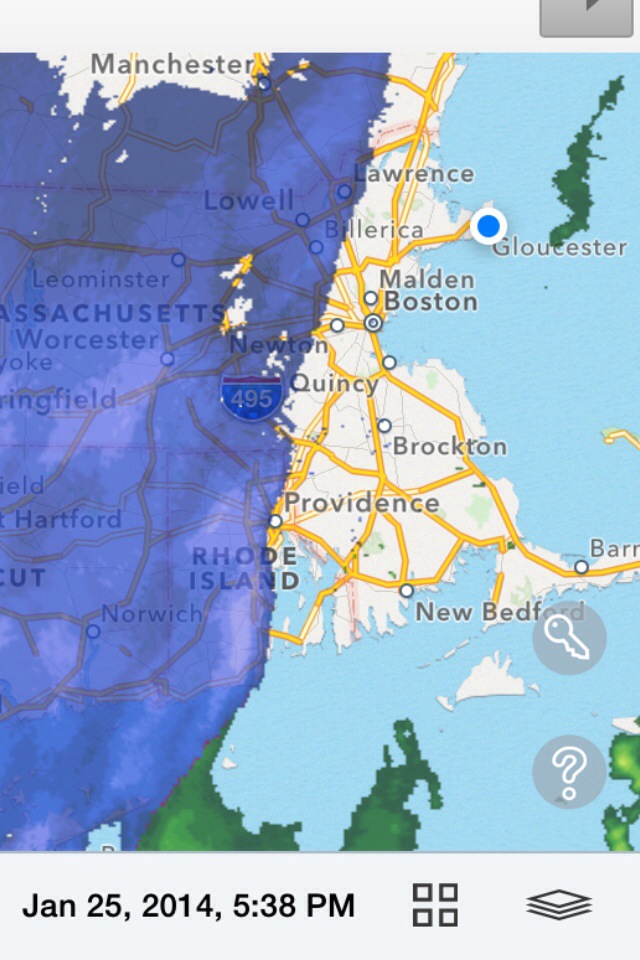
Tuesday February 4TH 2014 Cape Ann Forecast..

MARINE FORECAST …
Tue: N winds 5 to 10 kt…becoming SW in the afternoon. Seas 2 to 3 ft.

Tue Night: S winds around 5 kt. Seas around 2 ft. Snow likely. Vsby 1 to 3 nm.

Tuesday mostly sunny temps in the mid to upper 30’s with a light and variable wind … Tuesday night increasing clouds lows in the 20’s light winds from the south around 5-10mph .. Snow breaks out after 3-4 am Wednesday morning .. Wednesday snow heaviest from 5am-1or2pm looking at a Solid 8″ of heavy wet snow along with a gusty NE wind to 30mph !
Things should cool down by late Wednesday .. Dry out period Thursday through Saturday temps in upper 20’s to low 30’s .. Then all eyes turn to the south sat night late ESP Sunday into Monday big storm possible .. But it’s still 5-6 days out . Will deal with one storm at a time 🙂 Thanks for reading ..
Peter J Lovasco
GMG
Weatherman

20140203-183006.jpg

20140203-183022.jpg

Monday February 3RD 2014 Cape Ann Forecast..

Marine Forecast…
Mon: N winds around 10 kt. Seas around 2 ft.

Mon Night: N winds around 10 kt. Seas around 2 ft.

Monday storm system going underneath SNE will bring snow south of mass pike with possible flurries or light snow up to Cape Ann. Little or no accumulation expected . Highs 35-40 degrees with a northerly wind around 10 mph .. Monday clouds break becoming clear lows in the upper 20’s with a northerly wind around 5-10 mph.. Tuesday break highs in 30’s mostly sunny north to northeast winds 10-15 mph and becoming variable .. Now Tuesday night we see snow after midnight into Wednesday Afternoon , morning commute will be a nightmare ..

20140202-143908.jpg
Position of Low just south of Long Island shows us in heavy snow Wednesday am…

20140202-144027.jpg
Total Snow Fall Model Map for Wednesday .. Shows us in the pink area which to me would suggest 6-8″ of heavy wet snow …

20140202-144259.jpg
GFS 12z shows mainly a heavy snow event for Wednesday .. So all in all looks like a good lock for Wednesday … Have a wonderful Monday … Thanks For Reading …
Peter J Lovasco
GMG
Weatherman

20140202-144608.jpg

20140202-144704.jpg

Sunday February 2ND 2014 Cape Ann Forecast..

Well today is Ground Hog Day ! Will Punxsutawney Phil see his shadow or not ? Him who wants 6 more weeks of Winter?

20140201-095002.jpg

MARINE FORECAST..
Sun: SW winds 10 to 15 kt with gusts up to 20 kt. Seas 3 to 5 ft.

Sun Night: NW winds 10 to 15 kt with gusts up to 25 kt. Seas 3 to 5 ft.

Today’s Forecast … Mostly cloudy few showers possible highs 45-50 degrees.. Winds south west 10-15 mph.. Tonight mostly cloudy low around 35. West winds 10-15 mph…

20140201-095844.jpg

Saturday February 1st 2014 Cape Ann Forecast..

MARINE FORECAST…
Sat: W winds 5 to 10 kt…becoming S in the afternoon. Seas 2 to 3 ft.

Sat Night: S winds 10 to 15 kt with gusts up to 20 kt. Seas 3 to 5 ft. A chance of rain.

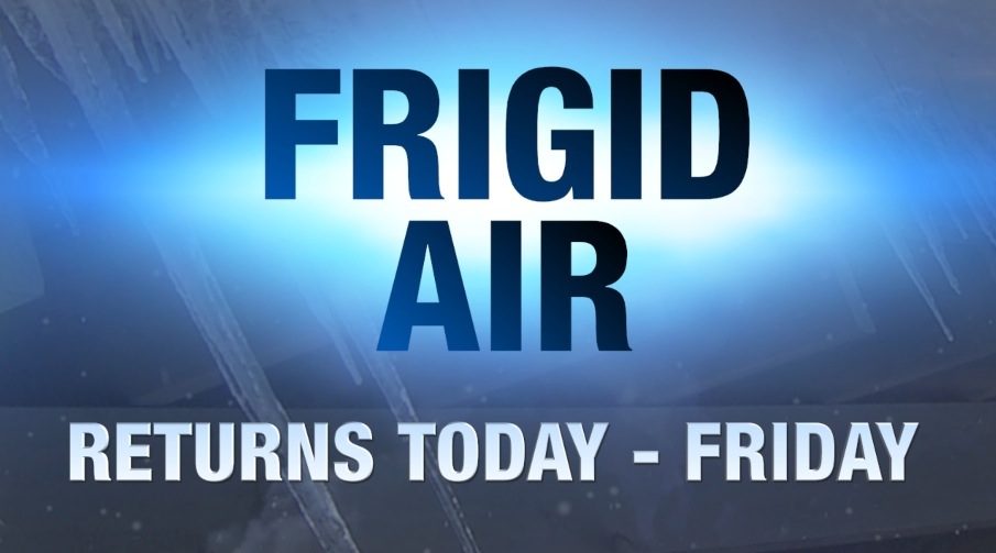
Today we’re looking at mostly cloudy conditions with temps in low 40’s. Winds rather light from the west at 5-10mph switching to the south late In the day . Saturday night chance of showers with mostly cloudy skies lows around 40 ..

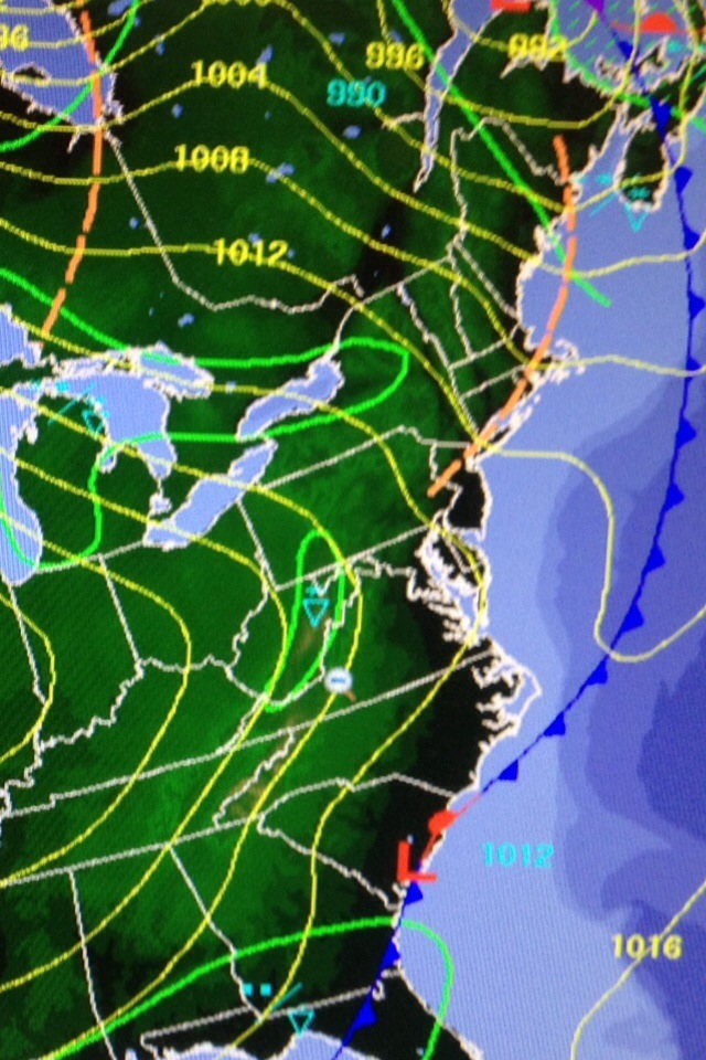
Ok so I wanted to do something different and explain different aspects of the weather . So with that being said let’s start out with “The High Pressure”

Ok so what’s a “High Pressure”
A high-pressure area, high or anticyclone is a region where the atmospheric pressure at the surface of the planet is greater than its surrounding environment.

Winds within high-pressure areas flow outward from the higher pressure areas near their centers towards the lower pressure areas further from their centers. Gravity adds to the forces causing this general movement, because the higher pressure compresses the column of air near the center of the area into greater density – and so greater weight compared to lower pressure, lower density, and lower weight of the air outside the center.

However, because the planet is rotating underneath the atmosphere, and frictional forces arise as the planetary surface drags some atmosphere with it, the air flow from center to periphery is not direct, but is twisted due to the Coriolis effect, or the merely apparent force that arise when the observer is in a rotating frame of reference. Viewed from above this twist in wind direction is in the same direction as the rotation of the planet.

The strongest high-pressure areas are associated with cold air masses which push away out of polar regions during the winter when there is less sun to warm neighboring regions. These Highs change character and weaken once they move further over relatively warmer water bodies.

Somewhat weaker but more common are high pressure areas caused by atmospheric subsidence, that is, areas where large masses of cooler drier air descends from an elevation of 8 to 15 km after the lower temperatures have precipitated out the lighter water vapor. (H2O is about half of the molecular weight of the other two main constituents of the atmosphere—Oxygen, O2, and Nitrogen, N2.)

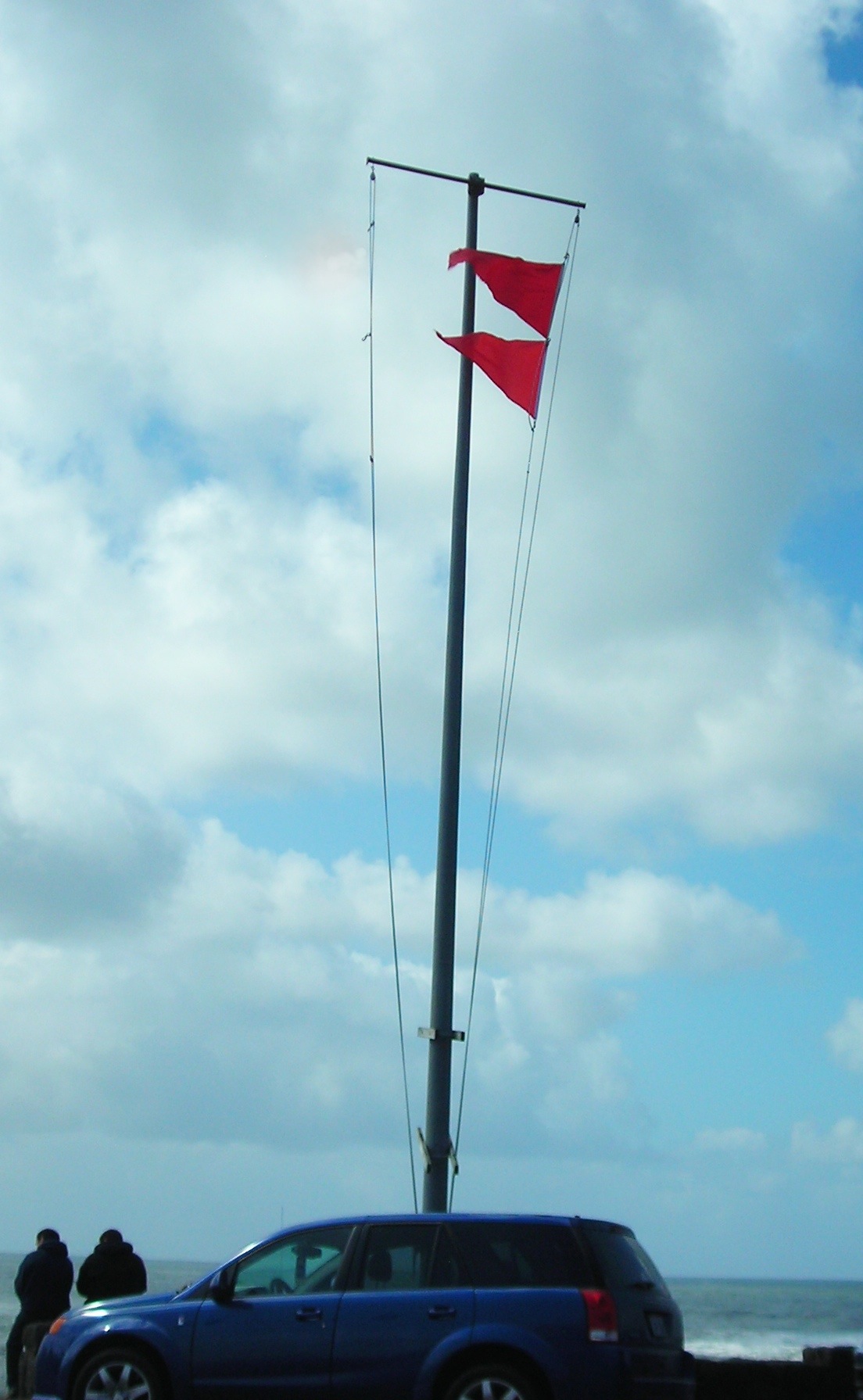
High pressures can be both our friends or enemies .. Case in point if u have a High Pressure like this one picture below …

20140131-080709.jpg
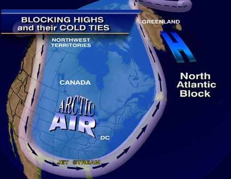
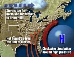
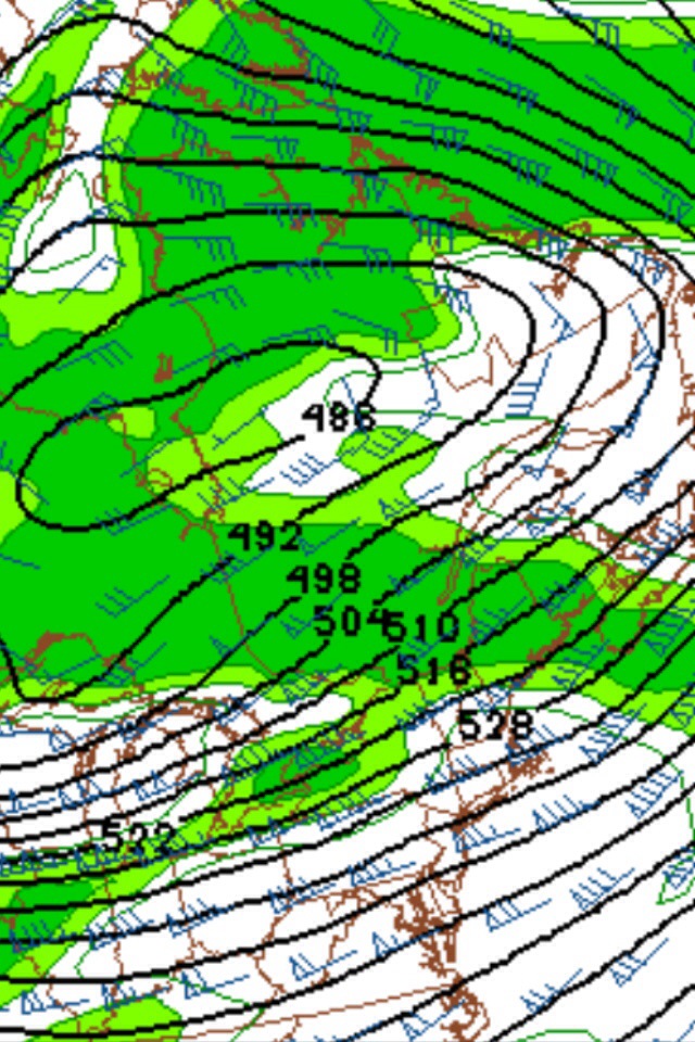
Then HOUSTON we have a problem .. This is called a “Blocking High” most common in winter months . When u have a very strong high pressure over Greenland , it tends to put on the brakes and cause a traffic jam of Weather across our country .. Most times results in stalling or retro grading monsters off the east coast resulting in lots of snow .. So if u here of A Greenland Block has set up just be ready for long duration storms..
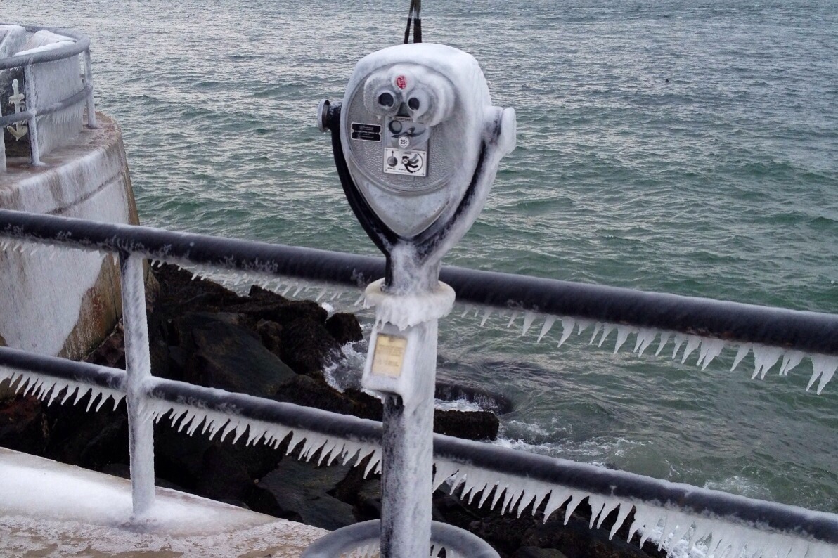
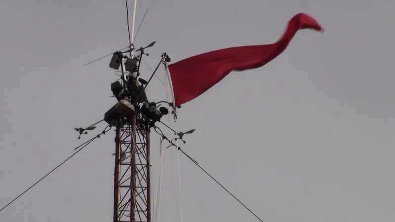
Now our friend “High Pressure” seen below …

20140131-081417.jpg
Is our warm mild position off the East Coast .. Bermuda Highs always bring in mild / warm / and tropical weather in the Summer months … Bermuda highs are often our good friends as far as weather goes .. How ever don’t be fooled During August ESP when Bermuda Highs can steer Tropical systems up our way ! IE. Tropical Storms / Hurricanes… So there’s Blocking Highs / Fair Weather Highs / And Bermuda Highs … Hope u enjoyed … Have a Wonderful Saturday !!!
Peter J Lovasco
GMG
Weatherman

20140131-082548.jpg

Thursday January 30th 2014 Cape Ann Forecast..

Thursday : Sun / clouds warmer with a high around 30 degrees. Southwest winds 15-20 mph .. Thursday Night clouds increase not as cold as previous nights lows around 28 degrees. With a southwest wind 10-15mph ..

Looks Stormy Next Week of February ..
Snow and or mixed events increases . Stay tuned …

MARINE FORECAST
Thu: SW winds 10 to 15 kt. Seas 2 to 3 ft.

Thu Night: SW winds 10 to 15 kt. Gusts up to 20 kt after midnight. Seas 2 to ft.

20140129-084519.jpg

Wednesday January 29th 2014 Cape Ann Weather Forecast..

MARINE Forecast…
Wed: NW winds 10 to 15 kt…becoming W 15 to 20 kt with gusts up to 25 kt in the afternoon. Seas 2 to 4 ft. A chance of snow. Vsby 1 to 3 nm.

Wed Night: W winds 15 to 20 kt with gusts up to 25 kt. Seas 3 to 5 ft. Light freezing spray likely.

Weather Blog: Jan 29th 2014

Well folks Spring is only 50 days away! I’m sure you’re ready for it , I know I am .. So far it’s been a pretty darn cold winter , averaging temps below normal and snowfall above normal ..
What can we expect going into February ? Well for starters February is normally our snowiest month of the season . We tend to get big storms that generate out of the “Gulf Of Mexico” these storms come fully fused with plenty of moisture .. They usually redevelop off the Outer Banks of NC. Over the Gulf Stream , which in part creates our Nor’Easters! Still waiting for Pacific Western Ridge to break down , signals it is starting to occur , this gives hope for Snow Lovers for February .. Also will be eyeing the Greenland Block set up in the North Atlantic , this will tend to keep storms from passing out to Sea, and also bring us potentially Stronger Storms . Hint Feb 25th “2010” monster ! So if u like snow I see plenty of chances going into February and into early March! If u don’t like the Snow , just remember Spring is only 50 days Away!! Have a great Wednesday Everyone.. And thank u for reading …
Peter J Lovasco
GMG Weatherman … 🙂

Tuesday January 28th 2014 Cape Ann Forecast.

Sun / clouds much colder temps in the teens to lower 20’s .. Windchill values will feel like -5 to -10 degrees …Busy West to North West wind 15-25mph..
Tuesday night frigid temps crashing through the lower teens to single digits . Low around 8 degrees ..

MARINE FORECAST..
Tue: W winds 15 to 20 kt…diminishing to 10 to 15 kt in the afternoon. Gusts up to 25 kt. Seas 2 to 3 ft.

Tue Night: W winds 10 to 15 kt with gusts up to 20 kt. Seas around 2 ft.

Extended Forecast Wednesday through Sunday low 20’s Wednesday fair / Thursday Sunny low 30’s / Friday 35-45 clear / Saturday poss snow showers 35-40 Sunday 42 degrees partly sunny .. Lows teens / 20’s..

A few computer model charts / maps I go by ..

20140127-111842.jpg

20140127-111900.jpg

20140127-111918.jpg

Monday January 27th 2014 Weather Forecast..

Cape Ann Weather
Monday A slight chance of showers between 11am and 3pm. Cloudy, with a high near 41. Southwest wind 15 to 17 mph, with gusts as high as 25mph.

Monday Night Mostly cloudy, then gradually becoming mostly clear, with a low around 11. Wind chill values as low as -3. Breezy, with a northwest wind 15 to 20 mph.

MARINE FORECAST ….
Mon: SW winds 15 to 20 kt with gusts up to 25 kt. Seas 2 to 4 ft. A chance of showers.

Mon Night: NW winds 15 to 20 kt with gusts up to 25 kt. Seas 2 to 3 ft.

My Met Weather Friend Mike Haggett Maine Weather & Myself Down Good Harbor Beach….

20140126-091102.jpg

Interview with my Special Guest Mike Haggett Maine Wx … Thanks Mike for you’re time was great seeing u pal !

Sunday January 26th 2014 Weather Forecast..

CAPE ANN WEATHER
Sun / clouds Frigid highs only around 20 degrees .. Late day increasing clouds with gusty west to north west winds 20-25mph…
Sunday night very cold lows in the single digits to lower teens , snow showers possible after midnight .. Not more then a dusting to a inch or two possible .. Tricky low pressure may form on front which could complicate things .. But for now taking the conservative approach ….

Marine Forecast
GALE WARNING!!!!
.SUN…W WINDS 25 TO 30 KT WITH GUSTS UP TO 40 KT. SEAS 6 TO
9 FT. FREEZING SPRAY LIKELY.
.SUN NIGHT…SW WINDS 15 TO 20 KT WITH GUSTS UP TO 30 KT. SEAS
3 TO 5 FT. LIGHT FREEZING SPRAY LIKELY. A CHANCE OF SNOW
SHOWERS.

Here are sum pics I took earlier this weekend showing the ICE covering STACY BLVD.. That’s how cold it’s been here in Gloucester !!!!

20140125-102034.jpg


BREAKING WEATHER! Saturday Evening Cape Ann January 25th

Heavy Snow Squalls Moving IN! Next 10-20 minutes , will cause for slippery travel and reduced Visibilities ! Drive cautiously if venturing out this Evening! Coating – 3″ possible ….

20140125-181426.jpg

Saturday Forecast ..

Sun / Clouds temps 28-36 degrees .. Watching late day Arctic cold front that will produce snow showers or periods of light snow late day / night . Accumulations will be rather light dusting – inch or two .. Temps dropping into single digits to 13 above at the shore … Winds southerly 20-30mph with higher gusts .. Continued breezy over night Saturday ..

GALE WARNING!!!
Marine Forecast
.SAT…S WINDS 20 TO 25 KT WITH GUSTS UP TO 40 KT. SEAS 4 TO
6 FT. SNOW SHOWERS LIKELY. VSBY 1 TO 3 NM.
.SAT NIGHT…SW WINDS 15 TO 20 KT…BECOMING W 20 TO 25 KT AFTER
MIDNIGHT. GUSTS UP TO 30 KT. SEAS 3 TO 5 FT. A CHANCE OF SNOW
SHOWERS. VSBY 1 TO 3 NM.
.SUN…W WINDS 20 TO 25 KT WITH GUSTS UP TO 35 KT. SEAS 2 TO
4 FT.
.SUN NIGHT…SW WINDS 10 TO 15 KT WITH GUSTS UP TO 20 KT. SEAS
2 TO 4 FT. A CHANCE OF SNOW SHOWERS..

20140124-122324.jpg

Extended Forecast through Wednesday Frigid temps teens and low 20’s . Lows single digits below to single above zero .. Snow threat Monday night through Wednesday time frame , but still to early to nail which day … Stay tuned.. Have a Wonderful Weekend stay warm Gloucester ! 🙂

Friday January 24, 2014 Cape Ann Forecast

Mostly sunny Skies with a few wispy high clouds from time to time , temps around 20 Degrees for you’re high..
Thursday Night partly cloudy temps falling into the single digits above Zero along the coast and below zero in inland locations …

Extended forecast Saturday – Sunday warmer temps Saturday with clouds and a few snow showers 30’s / Sunday Sunny with increasing clouds light snows possible by evening highs around 30-35 Degrees….

Marine Forecast :
Fri: NW winds 15 to 20 kt. Seas 3 to 5 ft. Freezing spray.

Fri Night: SW winds 15 to 20 kt with gusts up to 30 kt. Seas 2 to 4 ft. A chance of snow showers.

20140123-153049.jpg

Thursday Forecast

The frigid cold is here to stay for the next 10-15 days ….. Also plenty of storm chances in this extremely active weather pattern out of Canada.

Mariners Forecast

Small Craft Advisory
Thu: NW winds 10 to 15 kt. Seas 3 to 5 ft.

Thu Night: W winds 10 to 15 kt with gusts up to 20 kt. Seas 2 to 4 ft.

Will we ever see this again?

20140122-180218.jpg
I’m not so sure , but with this continued FRIGID WEATHER!!! I guess anythings Possible…
Have a great Thursday Gloucester 🙂

Wednesday Forecast …

Morning snow showers followed by cloudy skies / few sunny breaks 12-17 degrees .. Winds North 20-30 mph with gusts to 40mph…
Wednesday Night lows 5-10 above NW winds 15-25 mph gusts to 30 mph..
Wind Chill values 10-15 below zero ..

Marine Forecast
Wed: N winds 25 to 30 kt. Gusts up to 45 kt in the morning. Seas 9 to 14 ft. Light freezing spray. Snow. Vsby 1 nm or less.

Wed Night: NW winds 15 to 20 kt with gusts up to 25 kt. Seas 7 to 10 ft. Light freezing spray. A chance of snow showers.

20140121-212151.jpg

20140121-212257.jpg

Tuesday Forecast Jan 21st

Winter Storm Warning!!!
Gale Warning
Storm Warning further south / East
Tue: N winds 10 to 15 kt. Gusts up to 20 kt in the morning. Seas 2 to 3 ft. A chance of snow.

Tue Night: NE winds 20 to 25 kt with gusts up to 30 kt… Becoming N 25 to 30 kt with gusts up to 40 kt after midnight. Seas 5 to 8 ft. Light freezing spray likely. Snow likely. Vsby 1 nm or less.

20140120-190223.jpg

Monday Forecast Jan 20th

Small Craft Advisory
Mariners / Fishermen
Mon: W winds around 15 kt with gusts up to 25 kt. Seas 2 to 3 ft.

Mon Night: NW winds 15 to 20 kt…diminishing to 10 to 15 kt after midnight. Seas 2 to 3 ft.
Gloucester Get Ready For The Polar Vortex Part II…
Plenty Of Energetic Disturbance’s Through Out The Week .. Now Casting Event.. More On Detailed Weather
Forecast ….

Sunday Morning Forecast

Good Morning Gloucester here’s you’re Sunday Forecast … For boaters as well , and gale watch is up for Sunday with small craft advisory already in affect .. SW Winds 15-20 knots gusts to possibly 30knots seas 4-7 Ft…