Marine Forecast
Mon SW winds 5 to 10 kt. Seas 1 foot or less.
Mon Night SW winds 5 to 10 kt. Seas 1 foot or less. A chance of showers.
Video Forecast
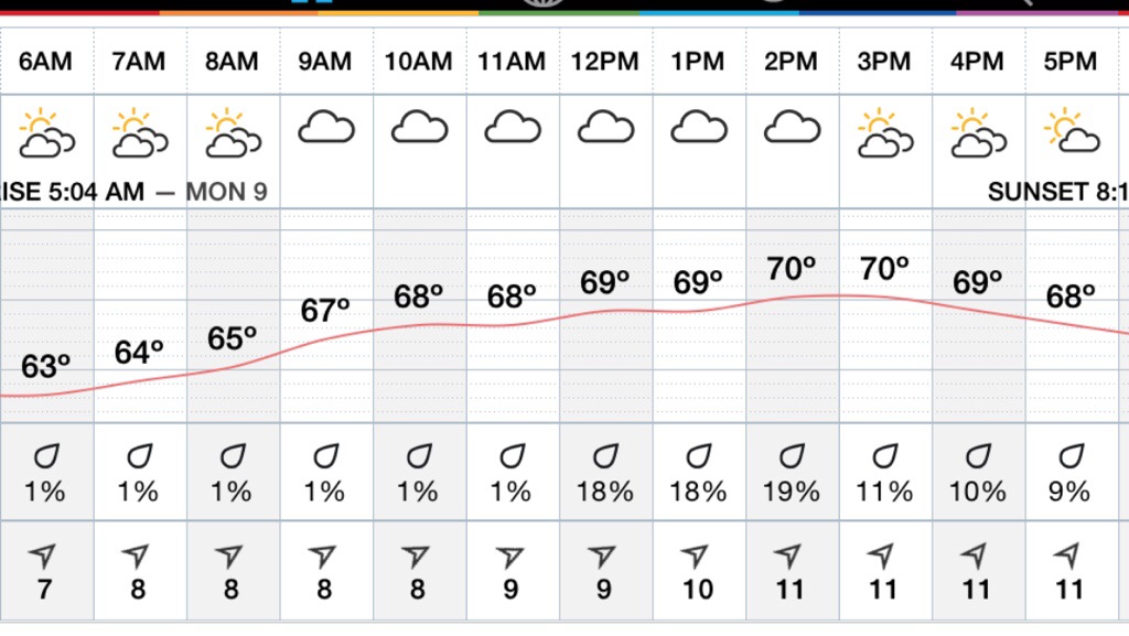
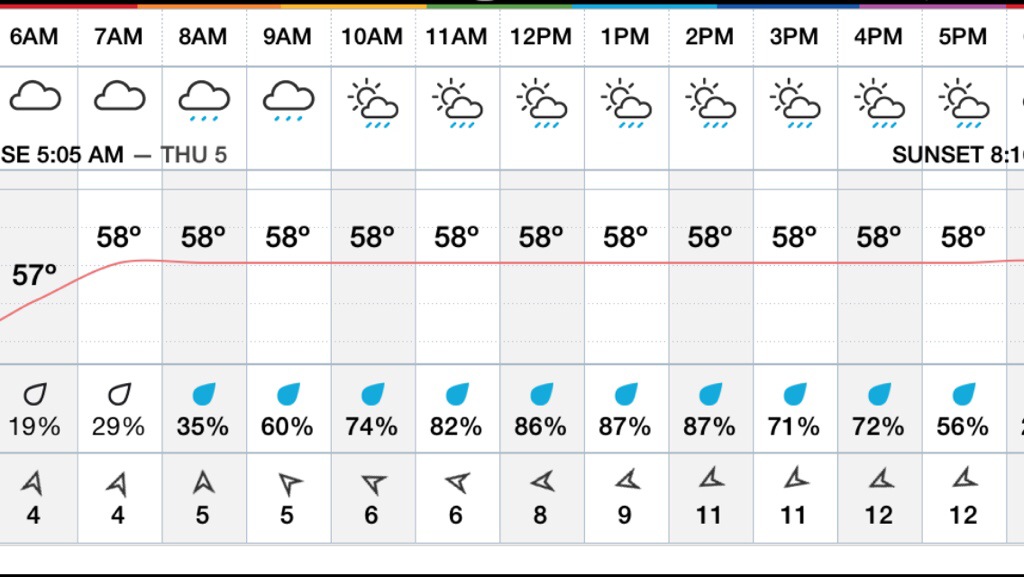
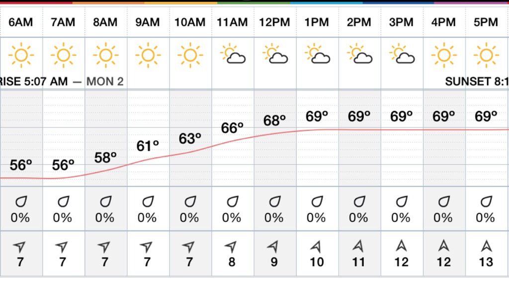
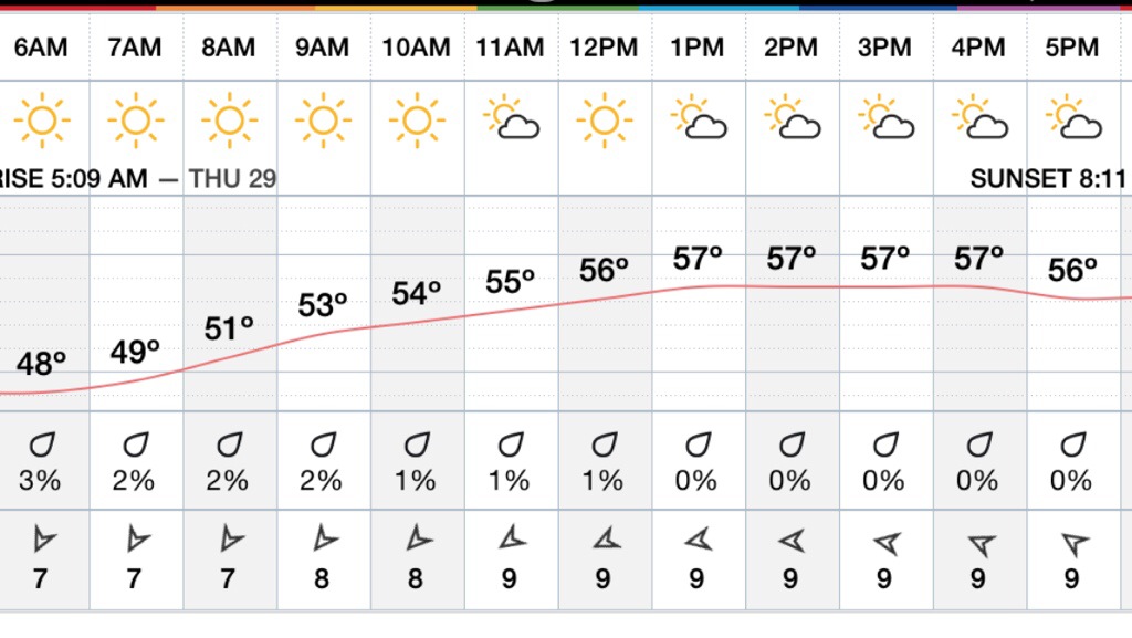
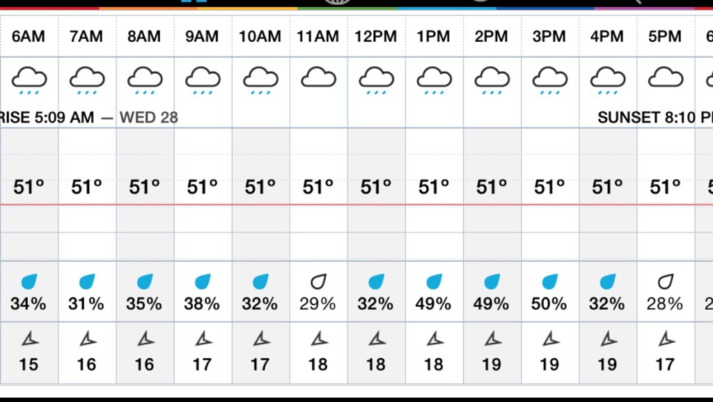
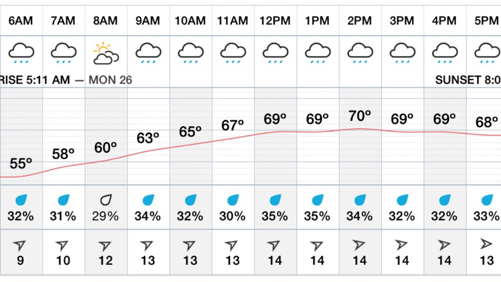
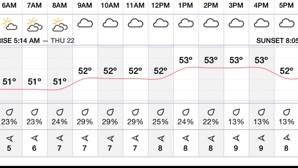
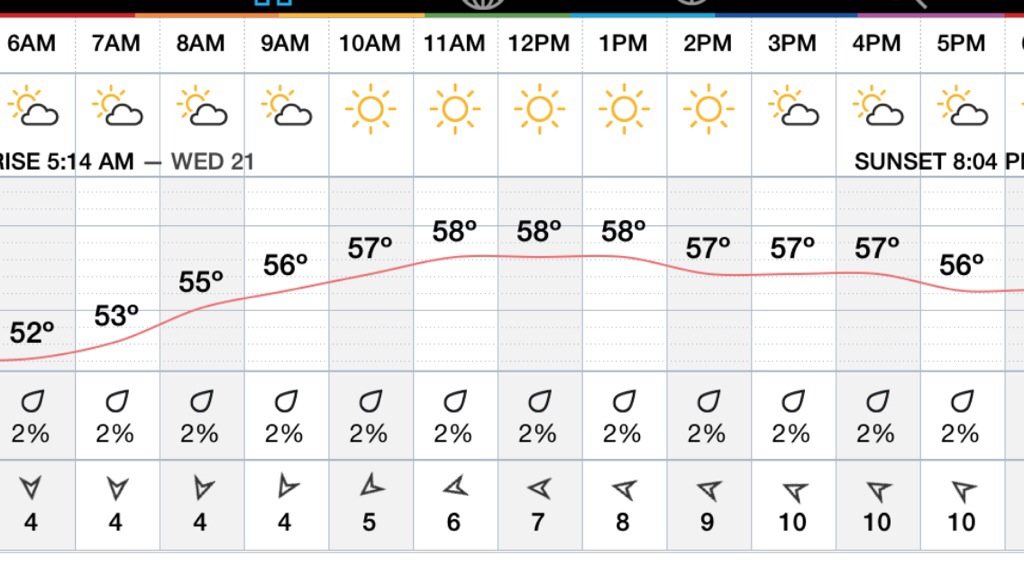
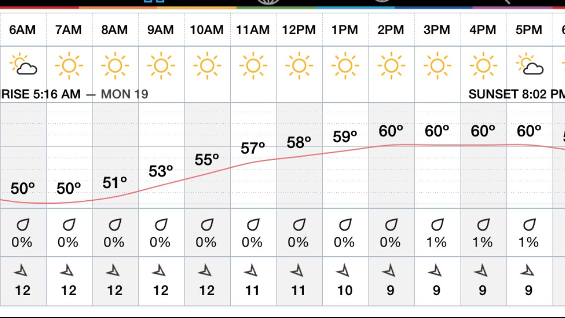
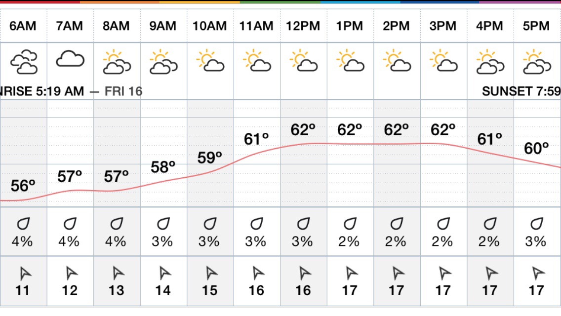
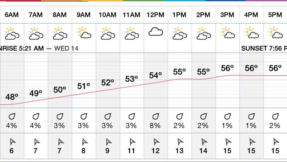
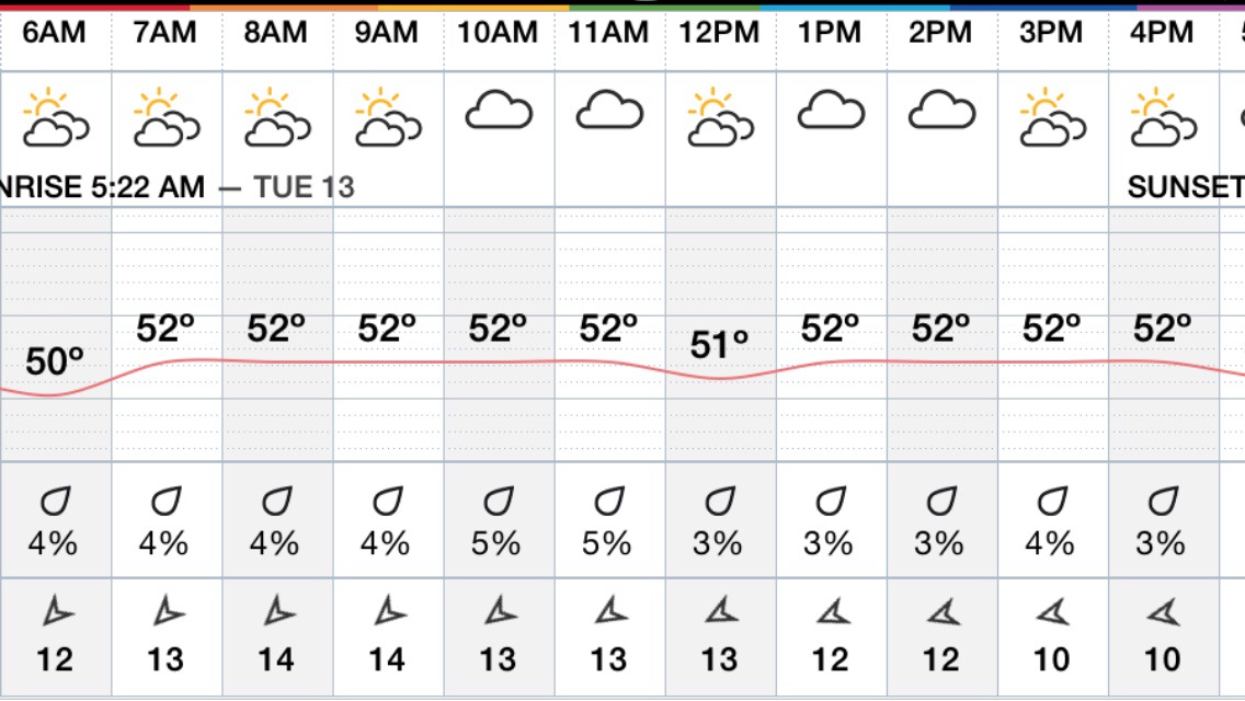
Hourly Forecast
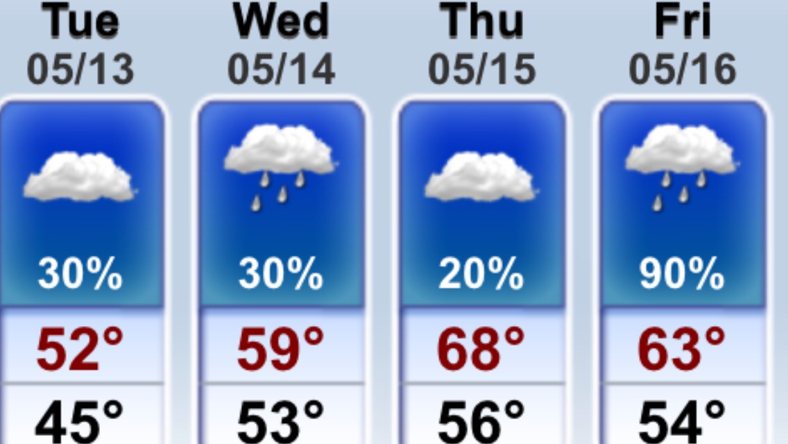
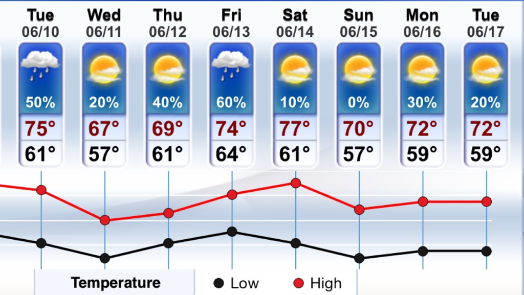
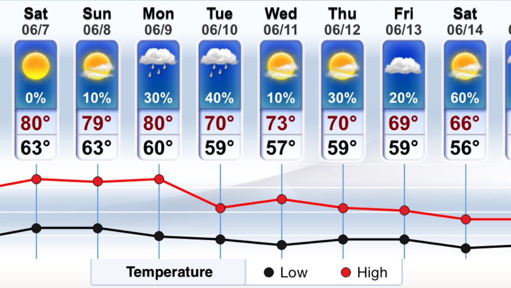
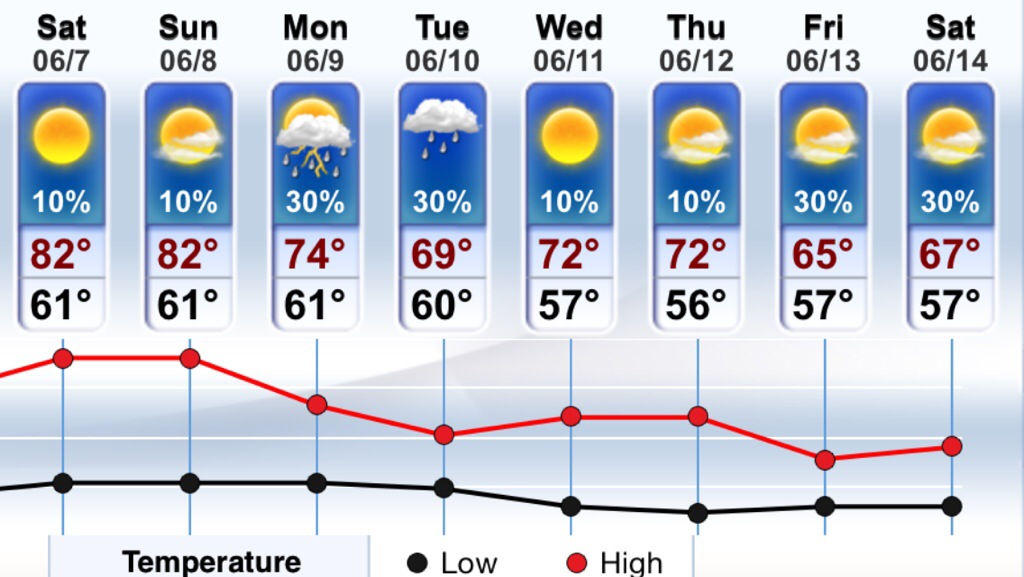
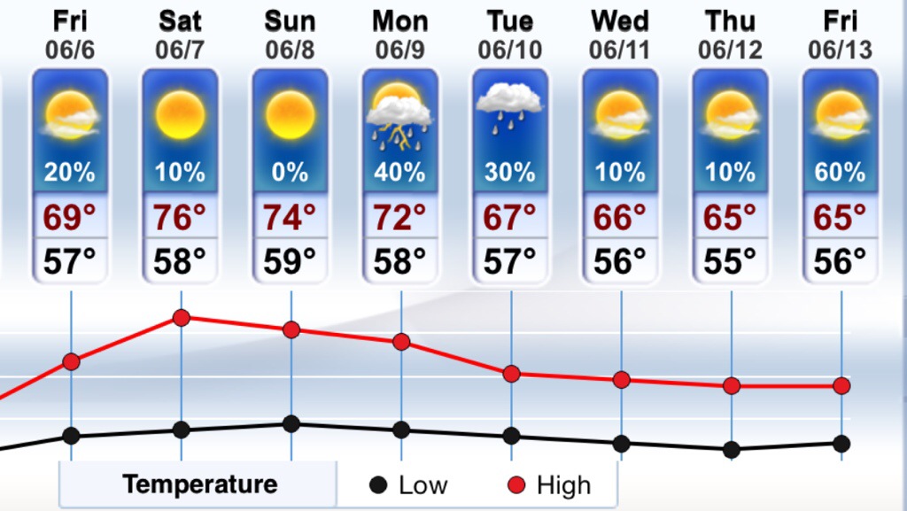
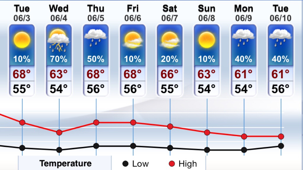
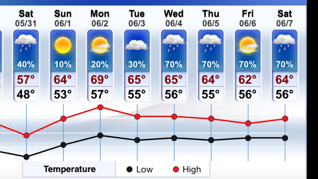
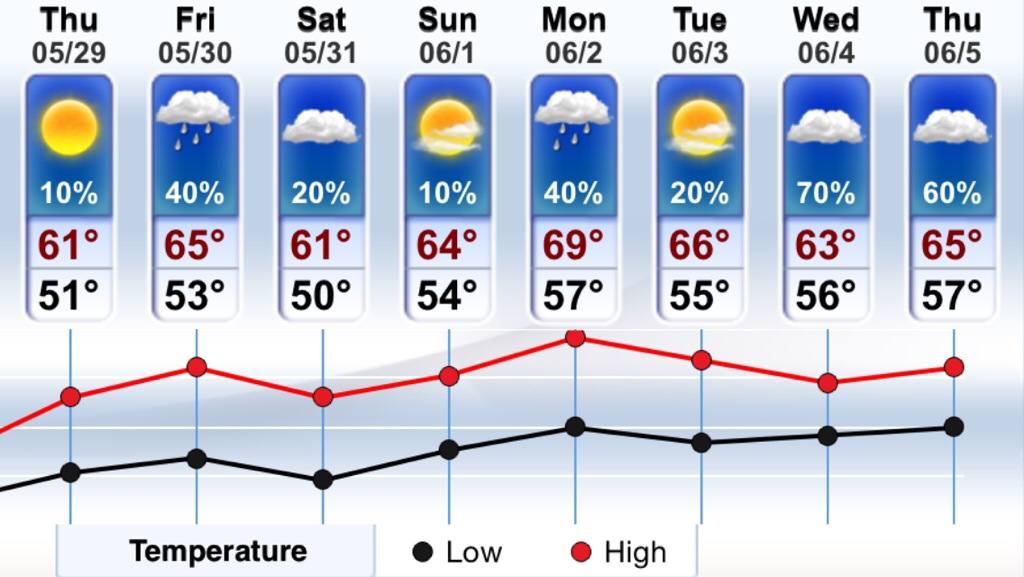
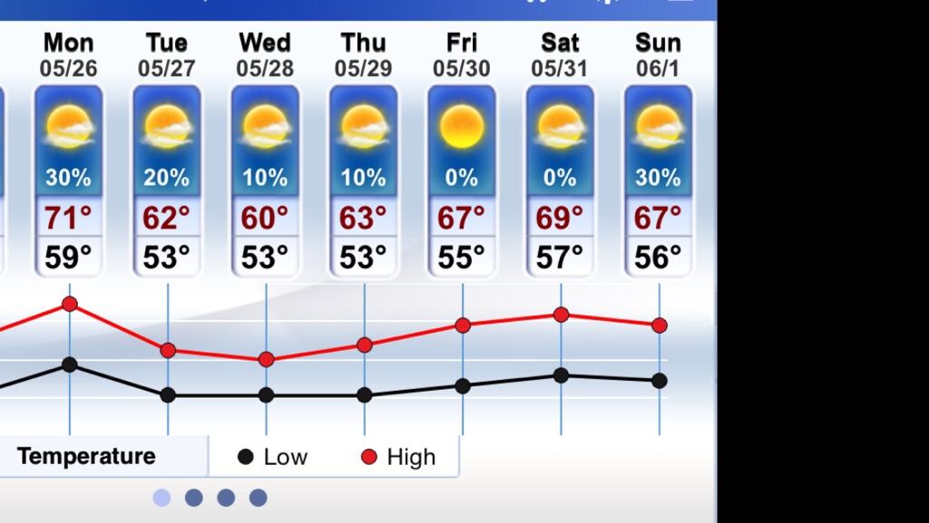
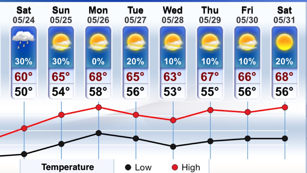
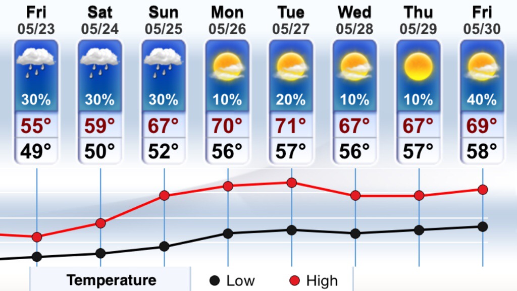
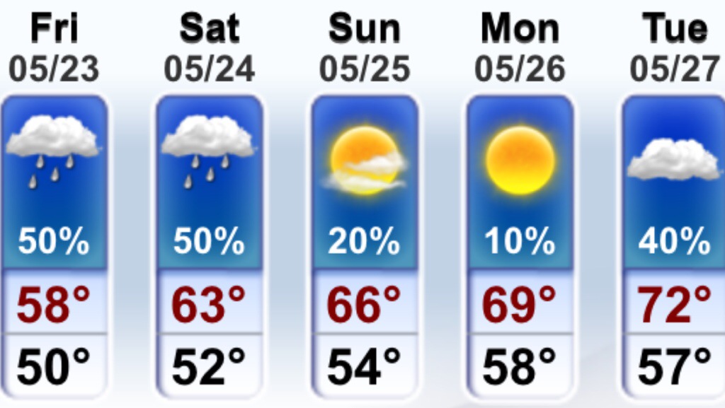
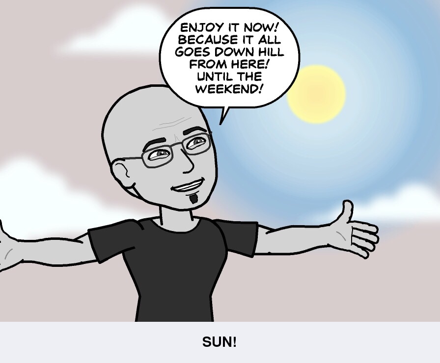
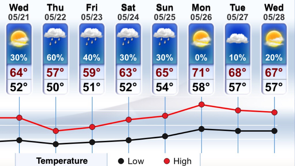
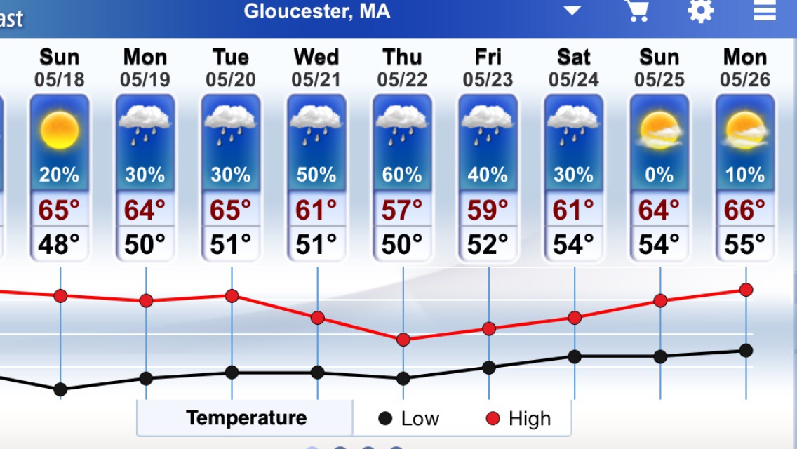
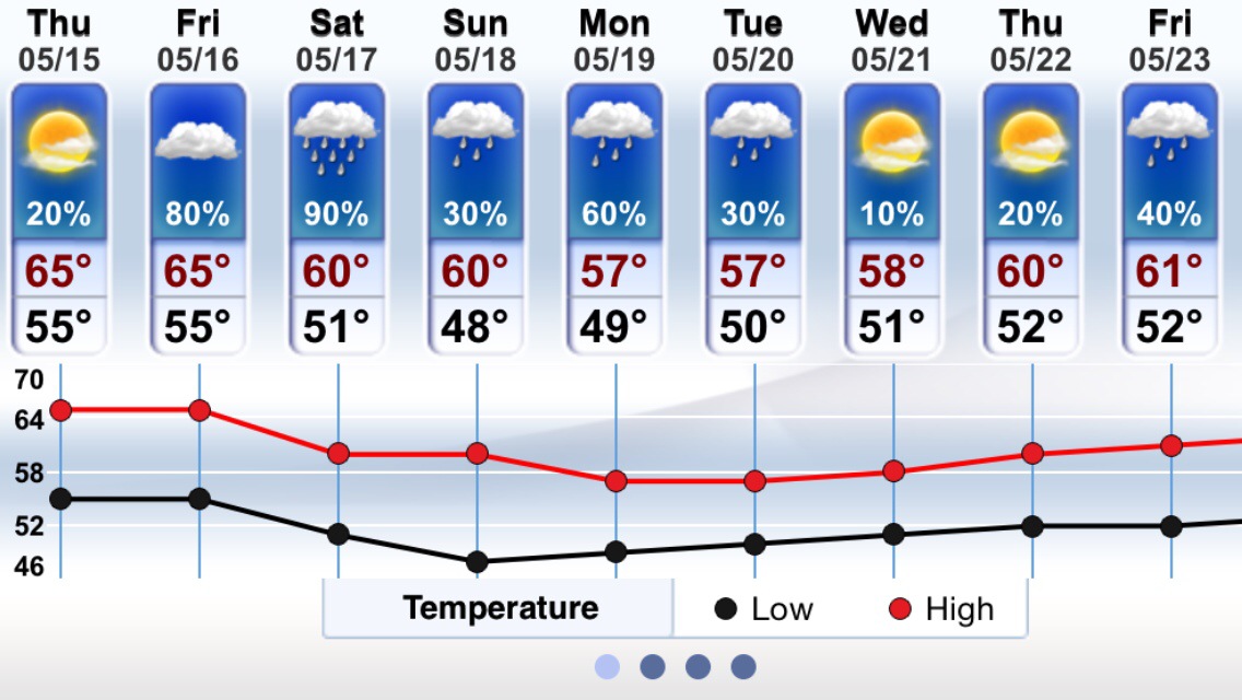
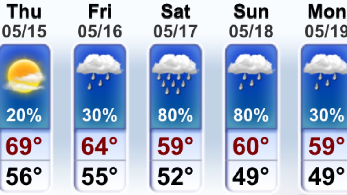
5 Day Forecast

My View of Life on the Dock
Marine Forecast
Mon SW winds 5 to 10 kt. Seas 1 foot or less.
Mon Night SW winds 5 to 10 kt. Seas 1 foot or less. A chance of showers.
Video Forecast
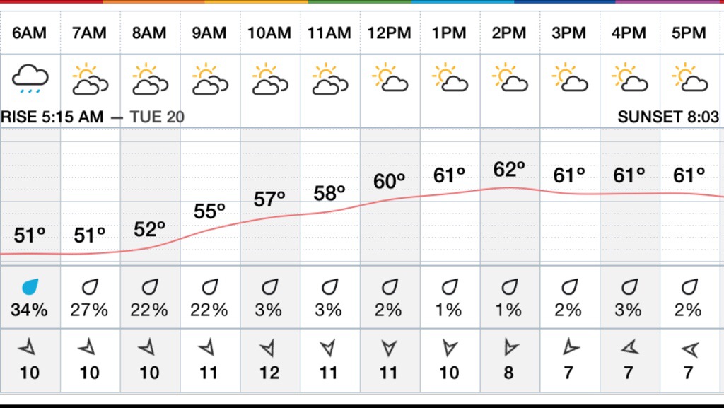
Hourly Forecast
5 Day Forecast

Marine Forecast…
Sat NW winds 5 to 10 kt…becoming S in the afternoon. Seas around 2 ft.
Sat Night SW winds 5 to 10 kt…becoming W after midnight. Seas around 2 ft.
Video Forecast…
Hourly Forecast
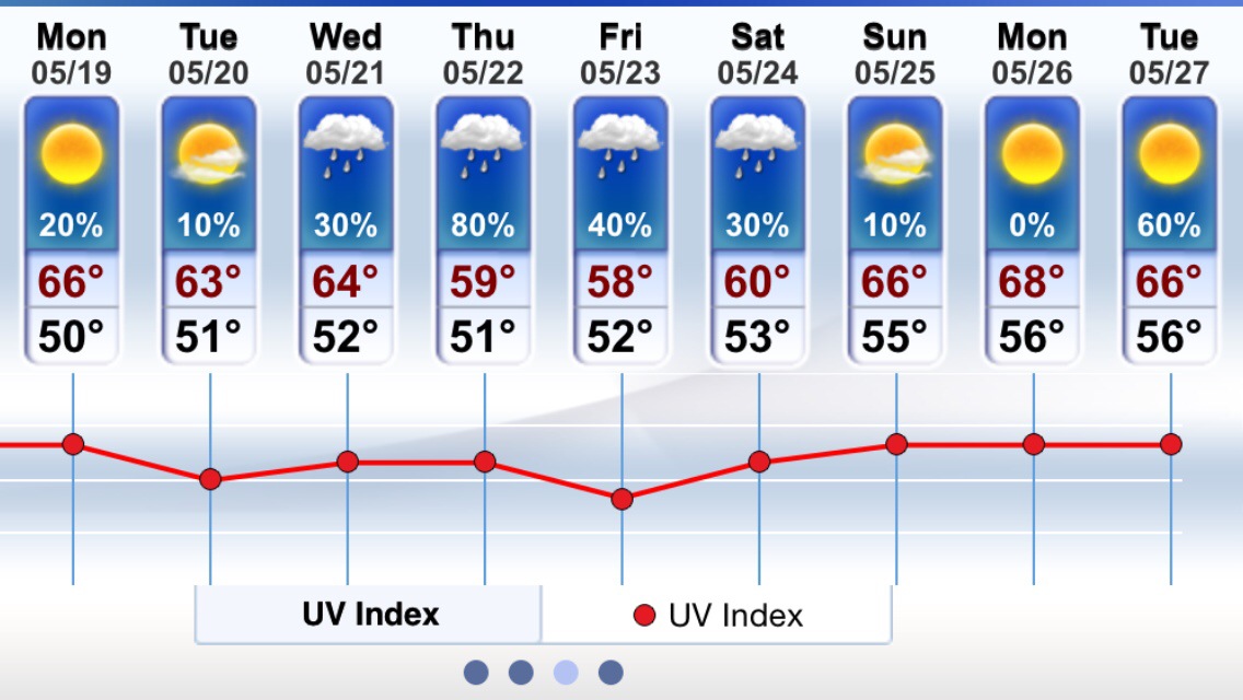
A Look At Next Weeks Forecast …


Marine Forecast
Fri W winds around 5 kt. Seas 2 to 4 ft. Patchy fog. Vsby 1 nm or less.
Fri Night W winds 5 to 10 kt. Seas 2 to 3 ft.
Clouds / sunny breaks / few pop up showers / storms . 66-76° warmest inland away from the coast . Light west winds 5-10mph becoming SE onshore 10-15mph ..
Friday night few early showers / storms possible lows dipping into the 50’s ..
Humidity and Mugginess arrives Sunday and Especially Monday Through Wednesday with Dew Points in the 60’s … So hang in there if u like humid / sticky / sultry weather…
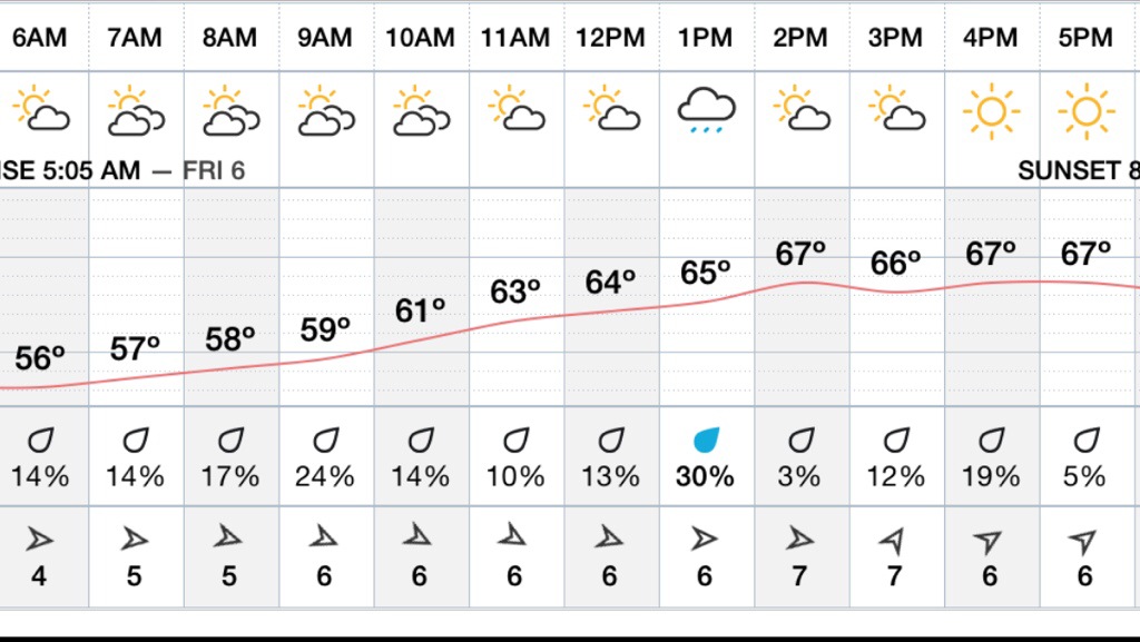
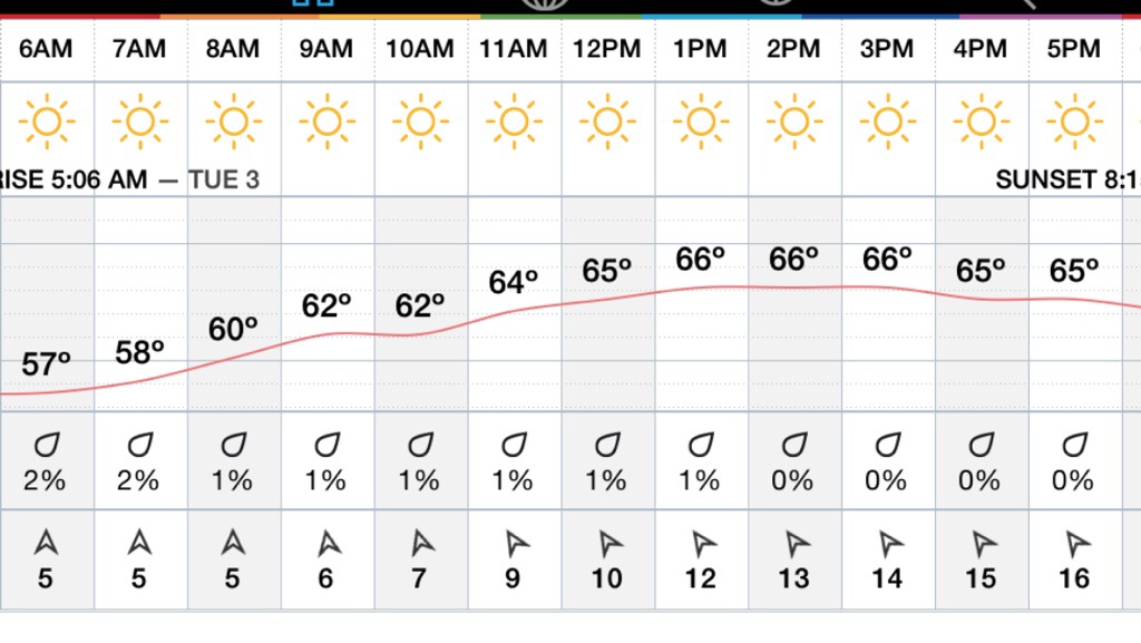
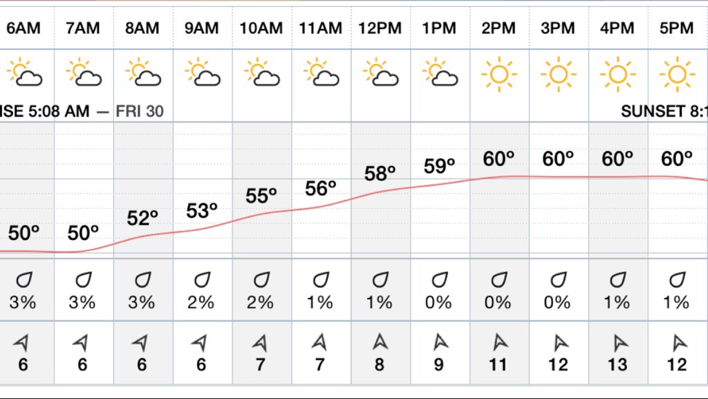
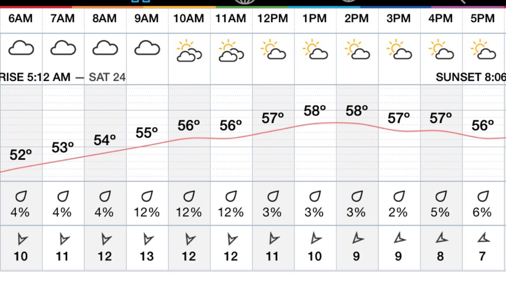
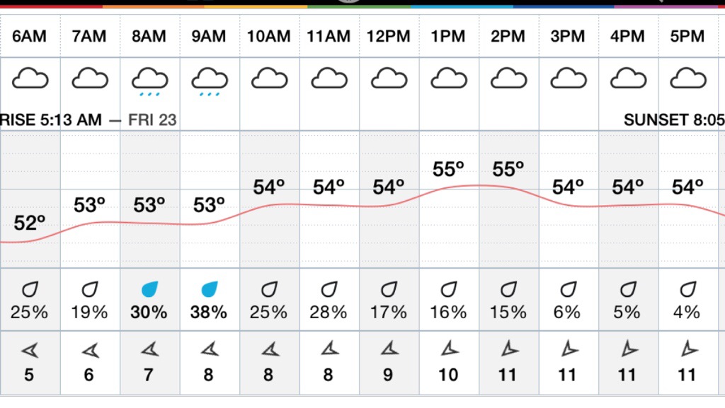
Hourly Forecast
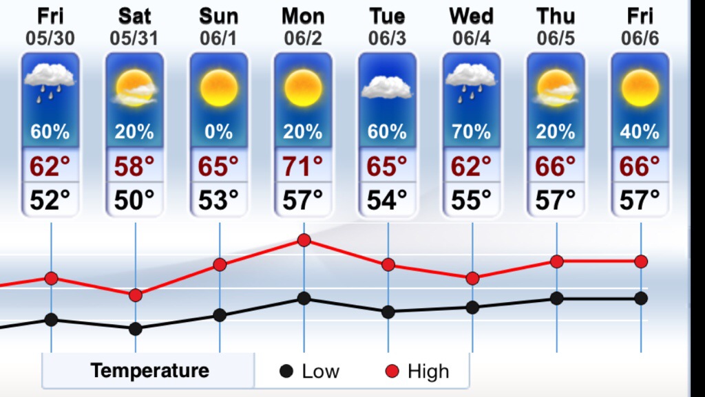
Weekend Outlook

Marine Forecast
Thu SE winds around 5 kt…becoming NE in the afternoon. Seas 2 to 3 ft. Patchy fog. Rain likely. Vsby 1 nm or less.
Thu Night N winds 5 to 10 kt. Seas 2 to 3 ft. Patchy fog. A chance of showers. Vsby 1 to 3 nm.
Today’s Forecast …
3 Words …… Wet , Fog , Cloudy…
Tonight few showers lows in the 50’s highs 55-65°
Hourly Forecast
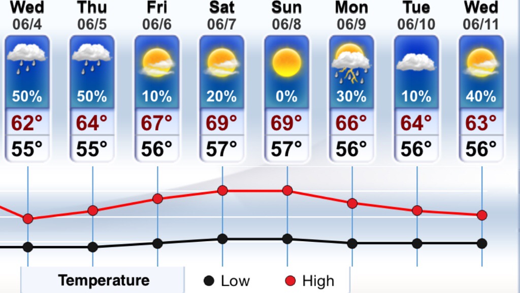
Extended Forecast..


Marine Forecast ….
Small Craft Advisory !
Tue SE winds 5 to 10 kt…increasing to 10 to 15 kt with gusts up to 20 kt in the afternoon. Seas 4 to 7 ft.
Tue Night SE winds 10 to 15 kt…diminishing to 5 to 10 kt after midnight. Seas 4 to 7 ft. Patchy fog. A chance of showers. Vsby 1 to 3 nm.
HIGH SURF ADVISORY!! With offshore storm very slowly moving away to the east , will continue to produce big surf 4-6ft waves on top of tide .. There is also a strong rip current …
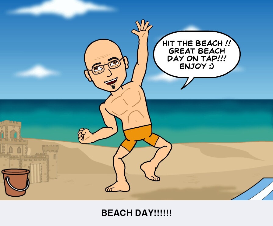
Beach Forecast… Temps 66-74° , sunny early / clouds late .. Winds SE 15-20mph , water temps 56° …
UV INDEX 6 .. Chance of evening storm .
Forecast pretty much the same as yesterday warm temps 70’s coast / 80’s inland with SE winds at the shore 15-20mph .. Mostly Sunny early increasing clouds late . Chance of a storm early evening hours …
Tuesday Night temps mid to upper 50’s light SE winds …
Hourly Forecast
Look Ahead …


Marine Forecast …
Small Craft Advisory…
Mon S winds 5 to 10 kt. Seas 2 to 4 ft.
Mon Night S winds 5 to 10 kt. Seas 2 to 4 ft.
Mostly sunny and Warm 66-75° at the shore with light onshore SE winds 5-15 mph .. 75-85° over the interior with calm winds.. Monday night clear lows in the lower 50’s inland to mid 50’s at the shore .. Light SE winds 5-10mph ..
Beach Forecast…
66-75° . UV INDEX 8 .. Water Temp 56° winds light onshore SE 5-15mph ..
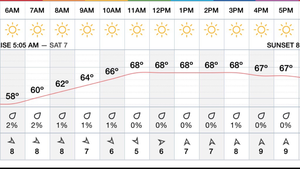
Hourly Forecast…
Extended Forecast…

Marine Forecast…
Fri S winds 5 to 10 kt. Seas 2 to 3 ft. A chance of showers.
Fri Night S winds 5 to 10 kt…becoming NE after midnight. Seas 2 to 3 ft. A chance of showers and tstms.
Video Cast….
Hourly Forecast…
Weekend Forecast…


Marine Forecast…
Thu NE winds 5 to 10 kt…becoming E in the afternoon. Seas 2 to 4 ft.
Thu Night S winds 5 to 10 kt. Seas 2 to 4 ft.
Thursday Forecast …Sun & Clouds mild but not warm mid to upper 50’s .. East to North East Winds around 10-15 mph … Thursday Night mostly clear temps dropping into the 40’s with a light south southeast wind 5-10mph..
Hourly Forecast …
Weekend Forecast….

Marine Forecast…
Wed NE winds around 15 kt with gusts up to 25 kt. Seas 2 to 4 ft. Patchy fog. Vsby 1 nm or less.
Wed Night NE winds 10 to 15 kt with gusts up to 20 kt… Diminishing to 5 to 10 kt after midnight. Seas 2 to 4 ft.
Video Forecast : Topic Hurricane Preparedness Week…
Hourly Forecast …
Extended Forecast ….

Sun & Clouds 60’s Late day Storms possible ! East winds light becoming west very late today … Hot Monday 85-90° no sea breeze …. Mostly sunny.
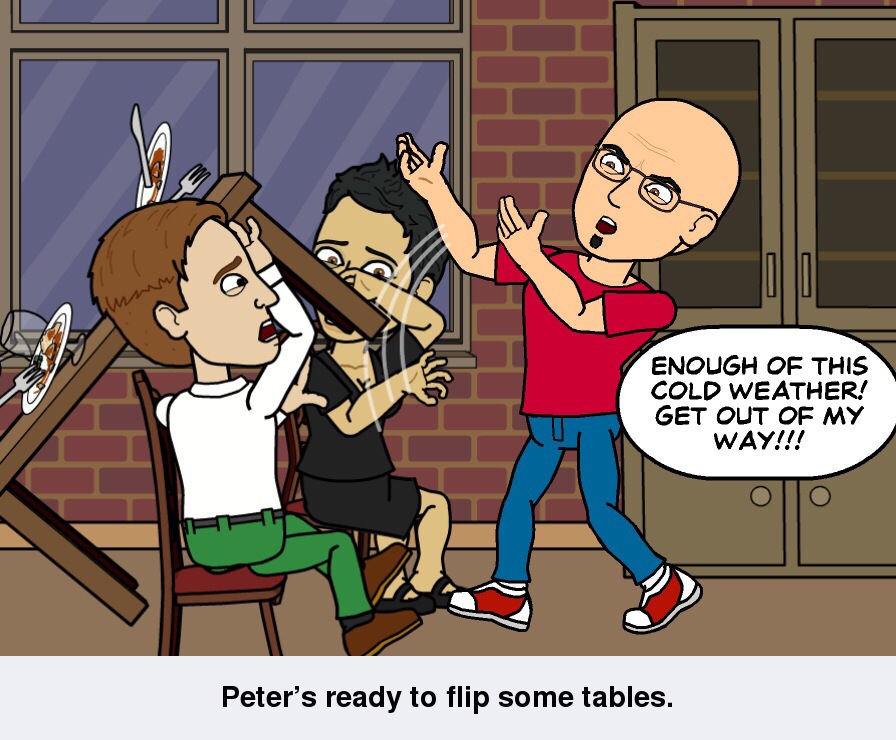
When Thunder Roars Go In Doors !!!!

Monitoring The Potential for Late Day Severe Storms . Primarily Western Essex County / central Middlesex County / and the Boston Western Burbs ! Not sure they will hold togeather as they approach Cape Ann after 4-5 pm ..
HAZARDS
DAMAGING WINDS
HAIL
HEAVY RAINS
DANGEROUS LIGHTNING
Also we can’t rule out a Brief Spin-up with the warm front and Seabreeze Front .. The turning of the winds and shear enhances along the warm front I.E. onshore light east flow bumps up against west south west flow along Warm Front ! It’s in this locale where the shear increases and the turning in the winds can produce a brief tornado ! So please keep eye on sky later today … My team is ready to roll if need be , will be on alert for traveling out west if and when Storms do fire ! … Stay tuned for updates later on today … Thanks GMG Weatherman Peter Lovasco ….


Marine Weekend Forecast …
Sat NE winds 10 to 15 kt…diminishing to 5 to 10 kt in the afternoon. Seas 2 to 3 ft.
Sat Night SE winds 5 to 10 kt…becoming SW after midnight. Seas 2 to 3 ft.
Sun SW winds around 5 kt…becoming SE in the afternoon. Seas 2 to 3 ft.
Sun Night SW winds 5 to 10 kt. Seas 2 to 3 ft.
Mon SW winds 5 to 10 kt with gusts up to 20 kt. Seas around 2 ft.
Mon Night W winds 5 to 10 kt. Seas around 2 ft.
Video Weekend Forecast ….
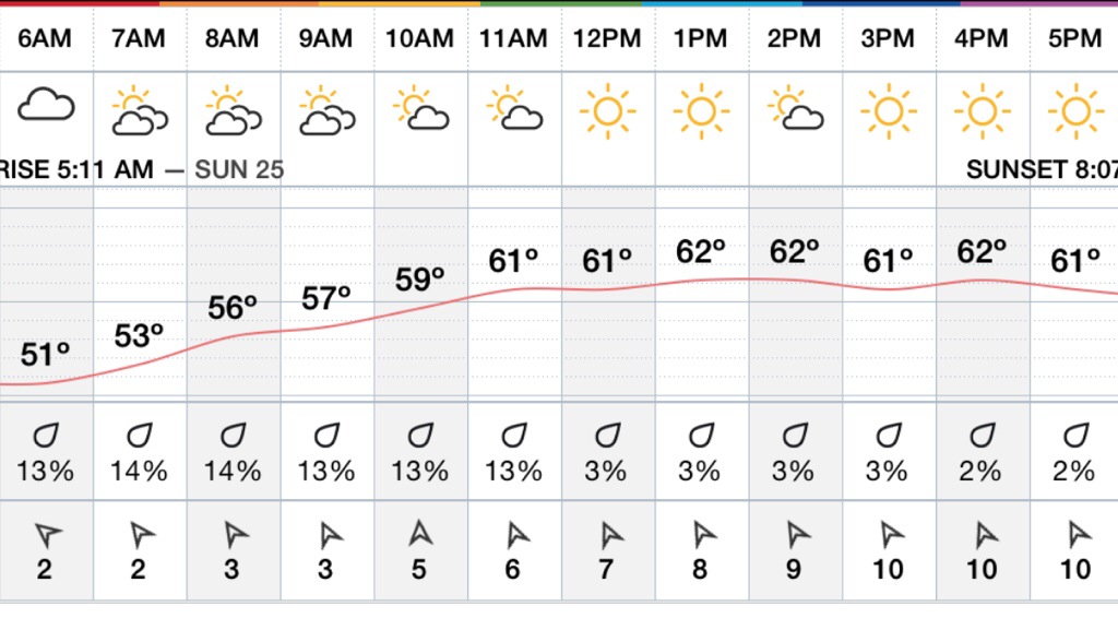
Hourly Forecast ….
Look ahead to next week …

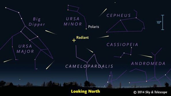
Don’t forget the Meteor Showers late Tonight ! With overcast may be hard to spot !

Marine Forecast :
Fri E winds 5 to 10 kt. Seas around 2 ft. Patchy fog. A chance of showers. Vsby 1 nm or less.
Fri Night NE winds around 10 kt. Seas 1 to 2 ft. A chance of showers.
Video Forecast :
Hourly Forecast :
Weekend Forecast / Memorial Day ..

Marine Forecast :
Thu E winds 5 to 10 kt. Seas around 2 ft. A chance of showers. Vsby 1 to 3 nm.
Thu Night E winds around 5 kt. Seas around 2 ft. A chance of showers.
Video Forecast :
Hourly Forecast :
Extended Forecast :


Marine Forecast :
Wed N winds around 5 kt…becoming E in the afternoon. Seas 2 to 3 ft.
Wed Night SE winds 5 to 10 kt. Seas 2 to 3 ft. A chance of rain.
Video Forecast :
Hourly Forecast :
Look Ahead :

Marine Forecast :
Tue NW winds 10 to 15 kt with gusts up to 20 kt…becoming NE 5 to 10 kt in the afternoon. Seas 4 to 6 ft.
Tue Night E winds around 5 kt…becoming W after midnight. Seas 2 to 4 ft.
Sun and Clouds with afternoon Sea Breeze’s highs in the 50’s shore to 70’s inland .. Along Sea Breeze convergence zone we may see the development of showers / storms .. Winds North west to 10mph inland and East North east on the coast! Tuesday Night any showers dissipate temps cooling down into the 40’s …..
Hourly Forecast :
Extended Forecast :


Marine Forecast :
Mon NW winds 10 to 15 kt. Gusts up to 20 kt in the morning. Seas 2 to 3 ft.
Mon Night NW winds around 10 kt. Seas 2 to 4 ft.
Video Forecast :
Hourly Forecast …
Look Ahead :
Lizzie Borden Event! Sponsored By MGHparanormalsociety.com It’s Going to Be Epic!! And I’ll be there !!! Only 4 Tickets Left!!!
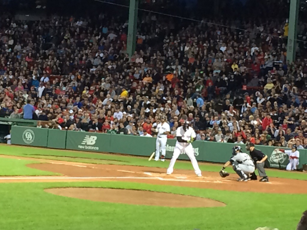
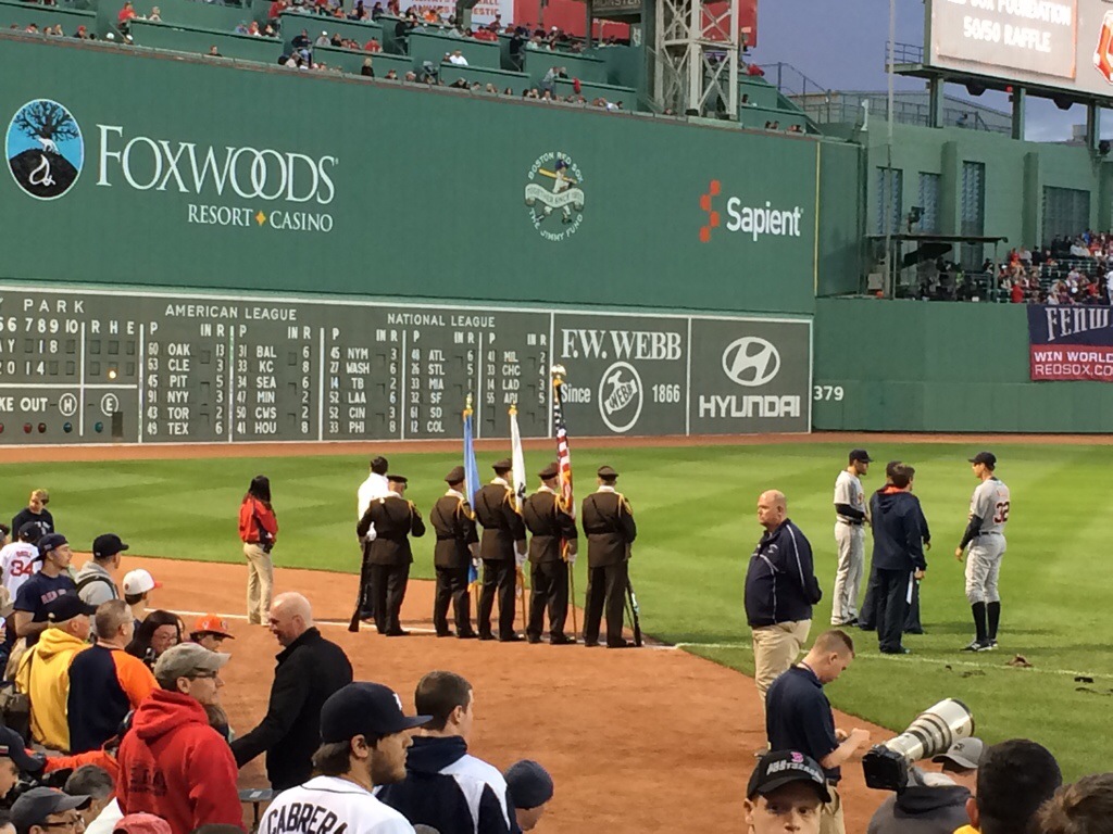
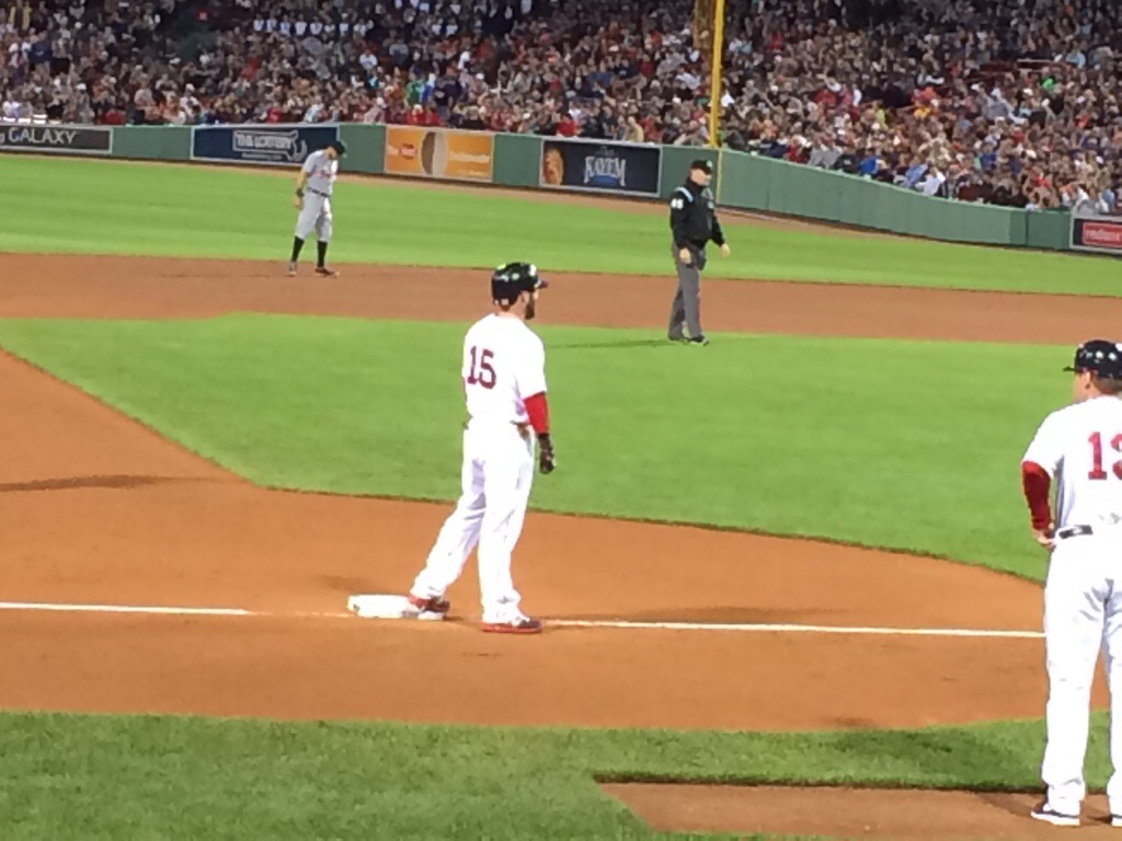
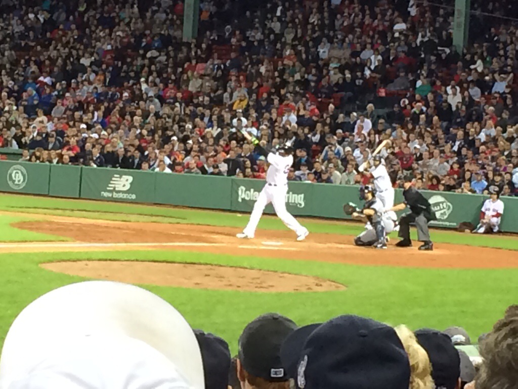
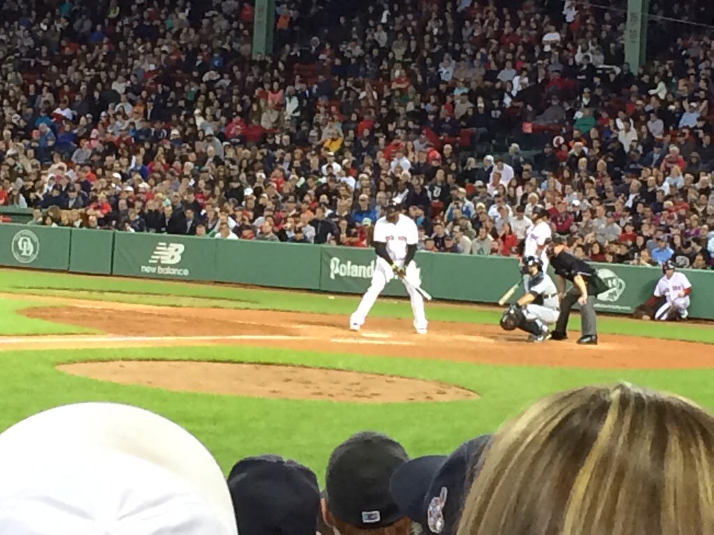
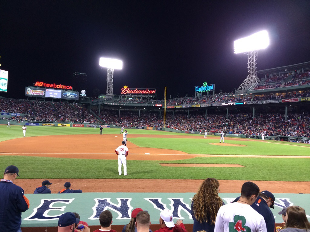
You’re weatherman enjoyed the Sox game even though they lost .. Here’s a few pics from Sunday Nights Game


Marine Forecast ….
Small Craft Advisory …
This Afternoon S winds 5 to 10 kt. Gusts up to 20 kt. Seas 3 to 5 ft. A chance of showers. Vsby 1 to 3 nm.
Tonight W winds 5 to 10 kt. Seas 2 to 3 ft.
Sun N winds 5 to 10 kt. Seas 2 to 3 ft.
Sun Night NW winds 5 to 10 kt. Seas 2 to 4 ft.
Video Forecast….

Marine Forecast :
Fri SE winds 10 to 15 kt…increasing to 15 to 20 kt in the afternoon. Seas 2 to 4 ft. Patchy fog. Vsby 1 to 3 nm.
Fri Night SE winds 15 to 20 kt with gusts up to 25 kt. Seas 2 to 4 ft. A chance of showers.
Video Cast :
Hourly Forecast :
Outlook For The Week Ahead :


Marine Forecast :
Wed SE winds 5 to 10 kt…increasing to 10 to 15 kt in the afternoon. Seas 2 to 3 ft.
Wed Night S winds 10 to 15 kt…diminishing to 5 to 10 kt after midnight. Seas 2 to 3 ft. Areas of fog. Areas of drizzle. Vsby 1 nm or less.
Video Forecast:
Hourly Forecast :
Extended Forecast :


Marine Forecast :
Small Craft Advisory :
Tue E winds 10 to 15 kt. Gusts up to 20 kt in the morning. Seas 2 to 3 ft.
Tue Night SE winds 5 to 10 kt. Seas 2 to 3 ft.
Well say goodbye to the 80’s and hello to the 40’s / 50’s today through Thursday , Sun / clouds / winds from East … Lows Tuesday night in the 40’s to lower 50’s .. With continued onshore wind .. precipitation chances increase Thursday night – through Friday Night with a chance of a round of thunderstorms and period of heavy rain .. Temps warm through the 60’s later in the week …
Hourly Forecast :
Extended Forecast :