Wednesday April 9th , 2014 Cape Ann Weather..

Marine Forecast ….
Wed NW winds 10 to 15 kt with gusts up to 20 kt. Seas 2 to 4 ft.
Wed Night NW winds 10 to 15 kt with gusts up to 20 kt… Becoming W 5 to 10 kt after midnight. Seas 2 to 3 ft.

Today Mostly sunny with highs in the lower 50’s .. North West winds 15-20mph… Tonight mostly clear lows in the 30’s to lower 40’s with a light North West Wind around 10 mph …
Hourly Forecast…

20140408-154055.jpg

20140408-154105.jpg

20140408-154124.jpg

20140408-154132.jpg

Tuesday April 8th , 2014 Cape Ann Weather…

Marine Forecast …
Small Craft Advisory through Tuesday Evening…
Tue S winds 15 to 20 kt with gusts up to 25 kt. Seas 3 to 5 ft. Patchy fog. Rain. Vsby 1 nm or less.
Tue Night W winds 15 to 20 kt with gusts up to 25 kt. Seas 3 to 5 ft.

Tuesday’s Video Forecast…

Hourly Forecast ….

20140407-193657.jpg

20140407-193719.jpg

20140407-195013.jpg

20140407-195027.jpg

Weekend Forecast For Cape Ann April 5th – 6th

Marine Forecast….
Small Craft Advisory Through Sunday Afternoon with Gusty Winds…
Today W winds 10 to 15 kt with gusts up to 20 kt. Seas 4 to 7 ft. Patchy fog this morning with vsby 1 to 3 nm.
Tonight W winds 20 to 25 kt with gusts up to 30 kt. Seas 4 to 7 ft.
Sun W winds 20 to 25 kt with gusts up to 30 kt… Diminishing to 10 to 15 kt with gusts up to 20 kt in the afternoon. Seas 3 to 5 ft.
Sun Night SW winds 5 to 10 kt. Seas around 2 ft.

Weekend Forecast morning fog , late morning clearing and sunshine 50’s .. Tonight temps fall into the upper 30’s to mid 40’s… Sunday mostly sunny 55-60°… West winds 10-20mph…. Sunday night temps in the 40’s…
Have a Great Weekend…. Thanks for viewing …
GMG
Weatherman
Peter Lovasco

20140405-103835.jpg

20140405-103850.jpg

20140405-103905.jpg

20140405-103919.jpg

20140405-103928.jpg

20140405-103937.jpg

Friday April 4th , 2014 Cape Ann Weather..

Marine Forecast …
Fri NE winds around 10 kt…becoming E in the afternoon. Seas 2 to 4 ft. A chance of showers.
Fri Night E winds 10 to 15 kt with gusts up to 25 kt. Seas 3 to 5 ft. Areas of fog. Showers likely. Vsby 1 to 3 nm.

Friday mostly sunny in the morning with an increasing threat of showers as we go later into the evening Highs in the low 40’s at the shore with a slight onshore wind variable 5-15mph!
Friday night wet/damp/raw lows in the upper 30’s with patches of fog! Se winds 15-20mph ….

Hourly Forecast….

20140403-164857.jpg

20140403-165028.jpg

20140403-165040.jpg

20140404-063908.jpg

Thursday April 3rd , 2014 Cape Ann Weather…

Marine Forecast….
Thu N winds 5 to 10 kt. Seas 2 to 4 ft.
Thu Night NE winds 5 to 10 kt. Seas 2 to 4 ft.

Thursday beauty plenty of Sunshine 45-50°degrees … Light North to North East winds 10-15mph .. Possible Sea-breeze at the shore cooling temps down into the lower 40’s… Thursday Night a few clouds lows in the 30’s with light North East winds 5-10mph…

Hourly Forecast ….

20140402-140819.jpg

20140402-140834.jpg

20140402-141053.jpg

Wednesday April 2nd , 2014 Cape Ann Weather..

Marine Forecast ..
Wed NE winds 5 to 10 kt…becoming SE in the afternoon. Seas 4 to 6 ft.
Wed Night S winds 5 to 10 kt…becoming W after midnight. Seas 3 to 5 ft.

Today Sunny with a few clouds 45-50° degrees .. Cooler along the shore with a light north east wind 5-10 mph becoming SE 5-10mph later in the afternoon .. Wednesday night partly cloudy not as cold lows 35-40° degrees with a light and variable wind…

Hourly Forecast ….

20140401-220044.jpg

20140401-220108.jpg

20140401-220123.jpg

Tuesday April 1st , 2014 Cape Ann Weather..

Marine Forecast…
Tue N winds 15 to 20 kt…diminishing to 10 to 15 kt in the afternoon. Gusts up to 30 kt. Seas 5 to 8 ft.
Tue Night NE winds 5 to 10 kt. Seas 4 to 7 ft.

Today sunny with a few clouds highs in the 40’s…North winds 15-20mph with gusts to 30mph.. Tonight partly cloudy light North East Winds 5-10mph .. Lows in the lower 30’s…
Happy April Fools day 🙂 thanks for viewing …..
GMG
Weatherman
Peter Lovasco

Hourly Forecast ….

20140331-143834.jpg

20140331-143844.jpg

20140331-143853.jpg

Monday March 31st , 2014 Cape Ann Weather..

Marine Forecast …
GALE WARNING!
Mon N winds 20 to 25 kt with gusts up to 40 kt. Seas 5 to 8 ft. Areas of fog. A chance of rain and sleet. Vsby 1 to 3 nm.
Mon Night N winds 20 to 25 kt with gusts up to 40 kt. Seas 6 to 9 ft. A chance of snow…sleet and rain.

Today mostly cloudy with periods or rain mixed with snow and sleet highs in the 30’s to lower 40’s … NE winds 25-35 mph with gusts over 45-50mph..
Monday Night rain / snow / sleet coming to a end lows in the upper 20’s to 30’s .. NE winds 20-30mph gusts over 45mph!!

I had the opportunity today to do a Live Stream From the Blue Shutters Inn on Nautilus Rd right on GHB… Also was welcomed inside the Shutter Inn and sat down with Ed Comer one of the Inn’s Owners … We talked about what else , the Weather of course 🙂 Ed had a lot of great stories to share with me and a very interesting guy .. I enjoyed my talk and time with Ed , and look forward to many more with the Blue Shutters Inn … Thanks Again Ed For Having me , u made me feel at home there.. 🙂 so I took some pics of the inside and I’d like to share them with u …. First pic Ed Comer my new good Friend …..

20140330-215837.jpg

Pictures of the inside of this Beautiful Inn on the Beach.. I’m telling u if you’re ever gonna visit Gloucester and need a Place to stay , u must experience The Blue Shutter’s Inn … The people are great , the staff is great .. must check it out ! Oh and the views are terrific !
Live stream recorded Earlier..
http://m.ustream.tv/recorded/45585183

image

http://www.blueshuttersbeachside.com/
We’re just steps from Good Harbor Beach in picturesque Gloucester…

20140330-220355.jpg

20140330-220543.jpg

20140330-220650.jpg

20140330-220815.jpg

20140330-221003.jpg

Sunday March 30th , 2014 Coastal Flood Threat Cape Ann ..

Not much flooding occurred at midday high tide , took a quick video cast to share with u . More concerned with tonight’s tide and Monday’s with cutoff LP south of us spinning in and generating a NE fetch off the ocean .. Rain should let up now with a return tonight and Monday , with colder air being drawn down from the north can’t rule out some snow shower activity getting involved as LP slowly moves off to the east ….
Also NE winds will begin to pick up late today and strengthen through Monday !

Pics from today’s High tide..

20140330-121941.jpg20140330-122053.jpg20140330-122153.jpg

20140330-122331.jpg

20140330-122446.jpg

Saturday March 29th – 30th Cape Ann Weekend Weather Cast..

Marine Weekend Forecast…
Sat NW winds 5 to 10 kt…becoming NE in the afternoon. Seas 2 to 3 ft. Showers likely. Vsby 1 to 3 nm.
Sat Night NE winds 10 to 15 kt with gusts up to 20 kt. Seas 2 to 4 ft. Rain. Vsby 1 to 3 nm.
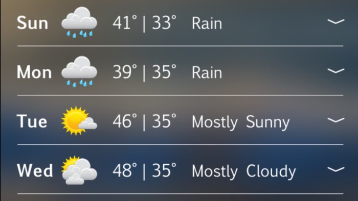
Sun NE winds 10 to 15 kt…becoming N 15 to 20 kt in the afternoon. Gusts up to 25 kt. Seas 3 to 5 ft. Rain. Vsby 1 to 3 nm.
Sun Night N winds 15 to 20 kt with gusts up to 25 kt. Seas 4 to 7 ft. Rain.
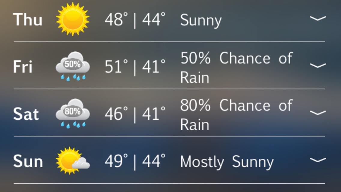
Weekend Forecast ……
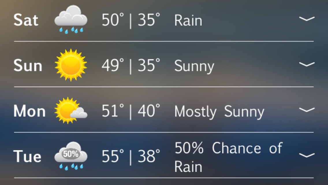
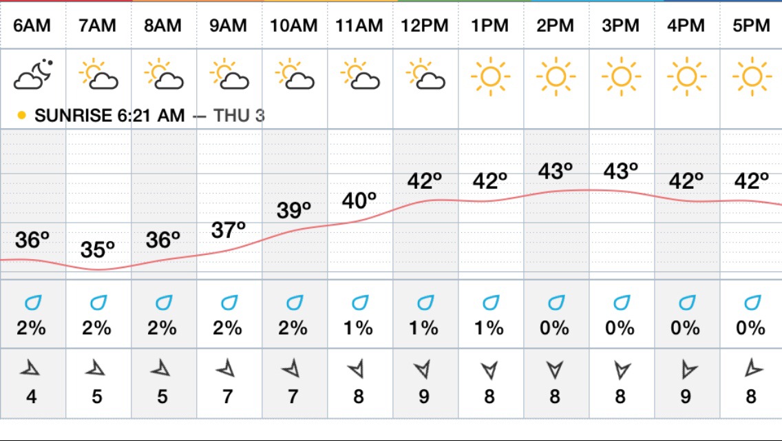
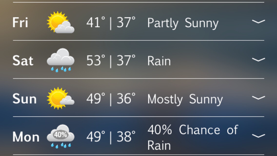
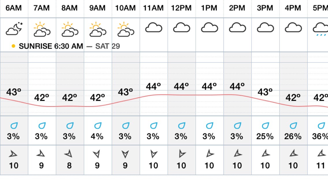
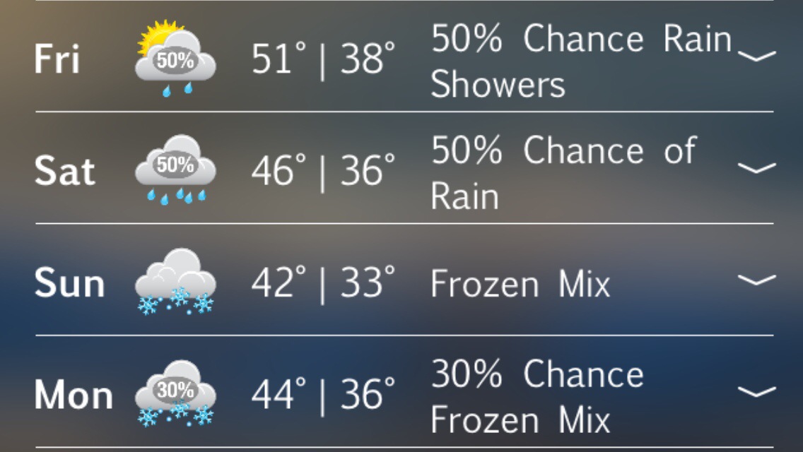
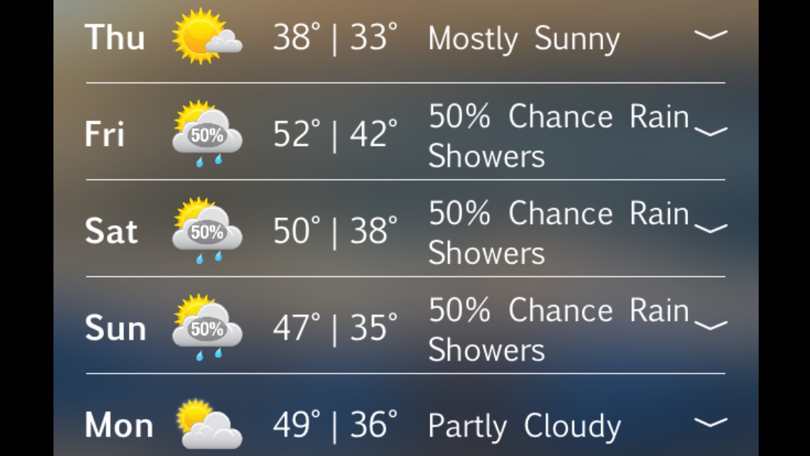
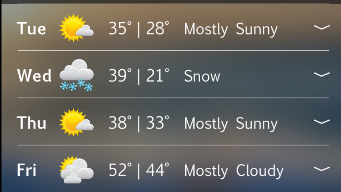
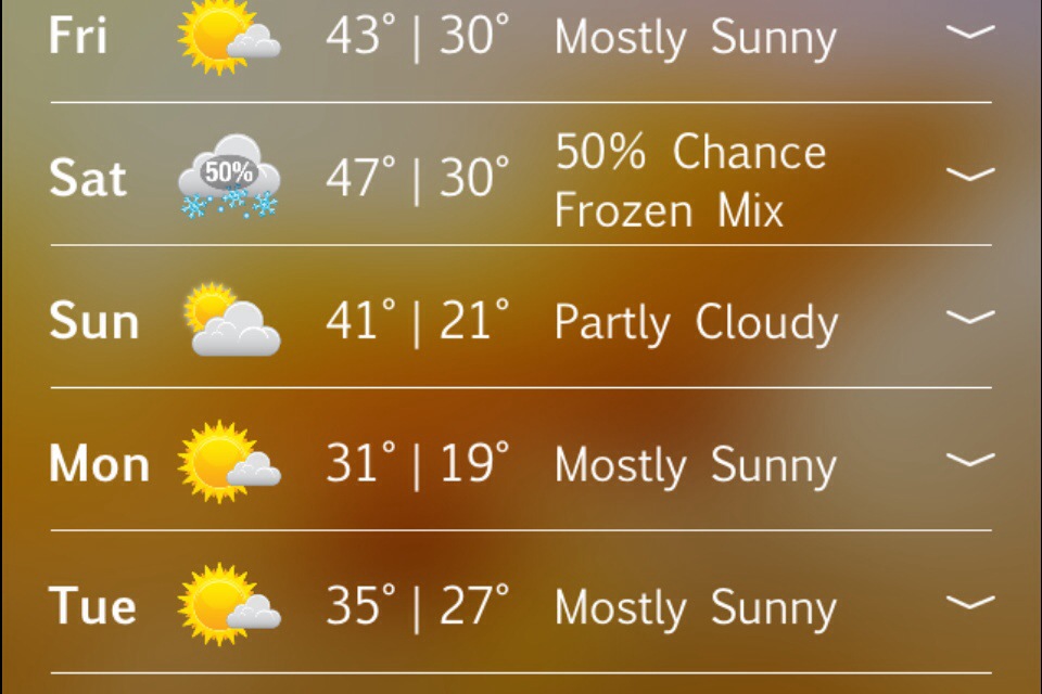
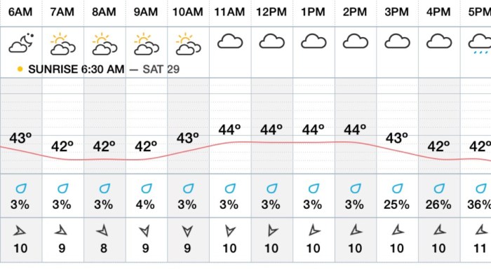
Sun and clouds  early Saturday then it goes all down hill from there.. Temps drop through the 40’s late Sat aft with heavy rains Saturday Night and Sunday … Lows Saturday Night around 37-43 degrees .. Sunday’s highs in the low 40’s cool and raw with periods of rain..
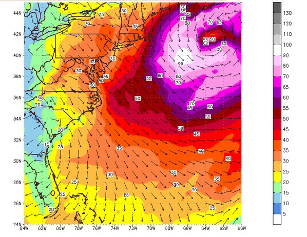
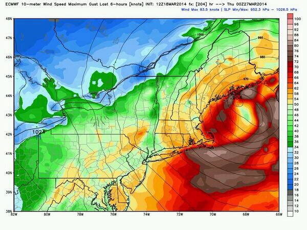
Winds begin to pick up later Saturday afternoon and ESP Saturday Night through Sunday from the NE at 25-35mph sustained with gusts close to 50mph!
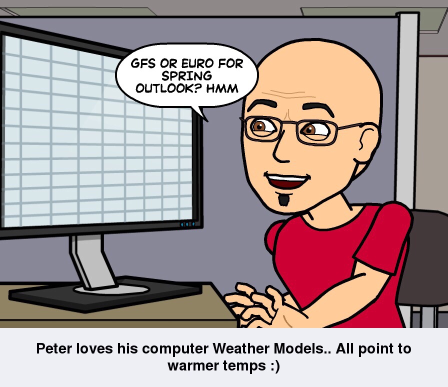
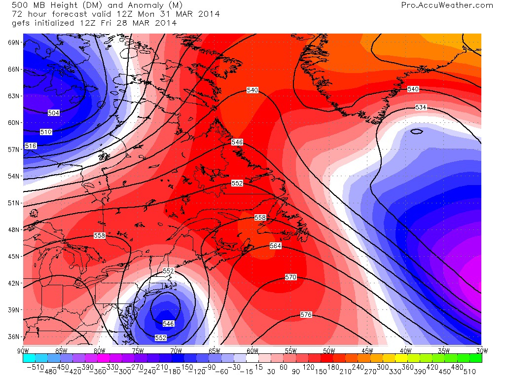
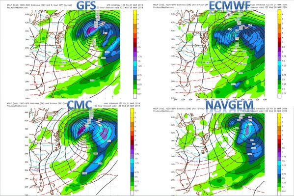
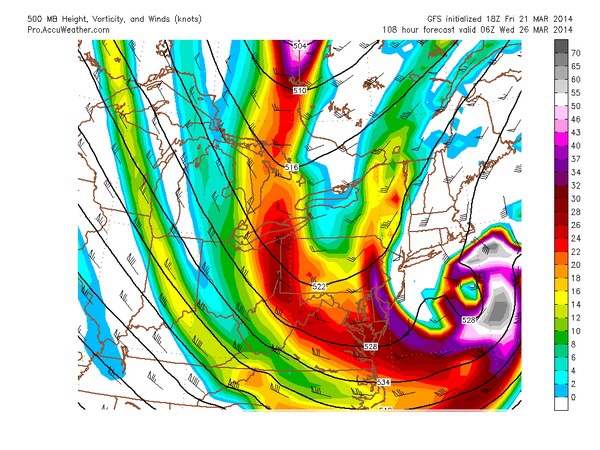
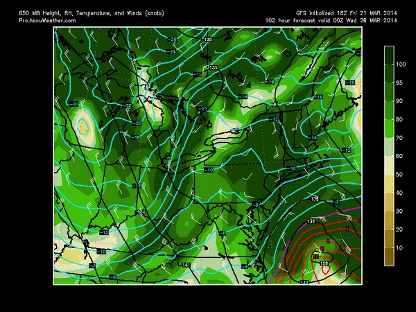
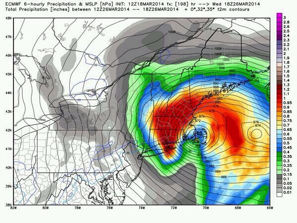
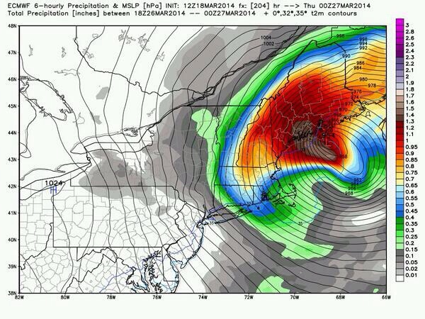
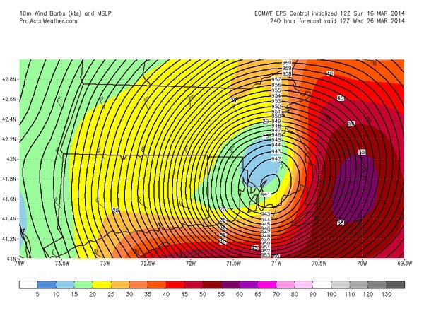
Depending on the position and strength of the low pressure system winds could be stronger then what I’m currently forecasting …Cut off low pressure will be trapped in the upper levels off our coastline south of Cape Cod due to the developing Blocking going on up in the North Atlantic . The “Greenland Block ” .. Via thanks to my pal Anthony for sharing this great graph ..

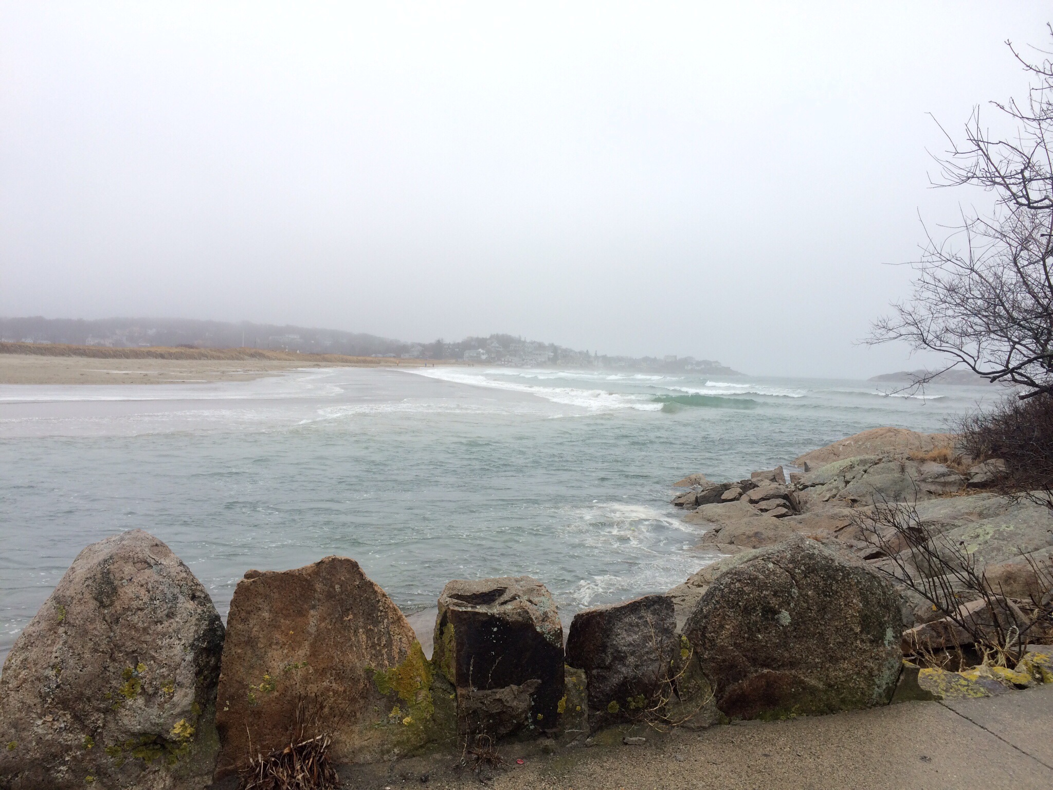
We also need to watch for excessive tide cycles with an onshore fetch for more then 48hrs .. Piling waves and water up on the coastline cycle after cycle .. Coastal Flooding will become a concern across Eastern Ma Coastal Communities minor to perhaps moderate with significant beach erosion also possible .. So something to watch very carefully ..

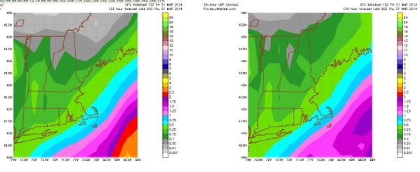
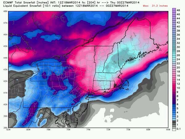
As Far as QPF amounts go , looking at a Widespread 2-4″ of rain with isolated locally higher amounts possible …

Worst Saturday Night Into Sunday …

Now the Wintery Aspect to this storm ..Will be carefully watching colder air drawing south Sunday Night and Monday from Northern New England and SE Canada .. It’s this cold air that may change our rain over to sleet then snow Sunday Night into Monday … Early guess would be for me to call for 2-4″ of snow , but that’s being premature and I need to see if there will be any precipitation left over on the back side of our departing low pressure system .. If it departs at all ..

No panic this isn’t a block buster or powerful storm / but it will be strong and we have managed much stronger storms then what this one will bring !
Thanks again for viewing …
Have a Great Weekend !
GMG
Weatherman
Peter Lovasco

20140328-185604.jpg

20140328-191612.jpg

20140328-191630.jpg

20140328-191642.jpg

Friday March 28th , 2014 Cape Ann Weather…

Marine Forecast…
GALE WARNING ! through early Evening!
Fri S winds 10 to 15 kt…increasing to 15 to 20 kt in the afternoon. Gusts up to 30 kt. Seas 3 to 5 ft. A chance of showers. Vsby 1 to 3 nm.
Fri Night SW winds 15 to 20 kt with gusts up to 30 kt… Becoming W 10 to 15 kt after midnight. Seas 3 to 5 ft. Patchy fog. A chance of showers. Vsby 1 to 3 nm.

Video Cast ….

Hourly Forecast…

20140327-195150.jpg

20140327-195217.jpg

20140327-195326.jpg

20140327-195343.jpg

Thursday March 27th , 2014 Cape Ann Weather..

Marine Forecast …
GALE WARNING! Through this Evening.
Thu NW winds 20 to 25 kt with gusts up to 35 kt…becoming W 10 to 15 kt with gusts up to 25 kt in the afternoon. Seas 4 to 7 ft. Light freezing spray.
Thu Night SW winds 10 to 15 kt with gusts up to 25 kt. Seas 2 to 4 ft.
Thanks For Viewing… 🙂
GMG
Weatherman Peter Lovasco

Video Cast….

Hourly Forecast…

20140326-211341.jpg

20140326-211356.jpg

20140326-211410.jpg

Wednesday March 26th , 2014 Cape Ann Weather…

Marine Forecast
Storm Warning
Hurricane Force Wind Warning much further off shore !
Wed N winds 25 to 35 kt…becoming NW 30 to 35 kt in the afternoon. Gusts up to 55 kt. Seas 8 to 13 ft. Areas of blowing snow. Snow. Vsby 1 nm or less.
Wed Night NW winds 30 to 35 kt with gusts up to 50 kt… Diminishing to 25 to 30 kt with gusts up to 40 kt after midnight. Seas 9 to 12 ft. Light freezing spray likely.

Major Powerful Nor’Easter just missing us by 100 miles … For the worsts impacts …that Being said some light snow showers will occur with 1-2″ possible . North east winds 25-35 with gusts over 50-55mph expected highs in the 30’s… Winds turn North late day 20-30 mph with gusts to 50-55mph..
Wednesday Night clearing temps drop down into the 20’s busy NW winds gusting to 35-40 mph…

So we missed the big one ! But that’s a good thing , because this would of been very damaging had it gotten closer to us .. we warm up Friday close to 60 degrees .. And looks like a wet cool raw weekend … More later have a great day .. Thanks for viewing …
GMG
Weatherman
Peter Lovasco

20140325-225733.jpg

20140325-225757.jpg

20140325-225956.jpg

Tuesday March 25th , 2014 Cape Ann Weather..

Marine Forecast …
Tue SW winds 5 to 10 kt…becoming S 10 to 15 kt with gusts up to 20 kt in the afternoon. Seas 1 foot or less.
Tue Night SE winds 10 to 15 kt…becoming NE 15 to 20 kt with gusts up to 35 kt after midnight. Seas 4 to 6 ft. Snow. Vsby 1 nm or less.

Video Cast…

Hourly Forecast…

20140324-205621.jpg

20140324-205645.jpg

20140324-205951.jpg

Monday March 24th , 2014 Cape Ann Weather..

Marine Forecast…
Mon NW winds 15 to 20 kt…diminishing to 10 to 15 kt in the afternoon. Seas 2 to 4 ft.
Mon Night NW winds 10 to 15 kt with gusts up to 20 kt… Becoming W 5 to 10 kt after midnight. Seas 2 to 3 ft.

Monday Forecast… Today will see mostly sunny skies with frigid temps for Spring 20’s will do it .. North West winds 10-15mph… Monday night
Very cold lows in the teens with a west wind 10-15mph …clear skies and wind chills in the single digits . Tuesday sun first thing in the morning will fade by late morning early afternoon in response to storm system coming up from the south . Highs in the 30’s with light south winds 5-10mph.. Clouds continue to increase late day with a few flurries possible .
Tuesday night overcast with temps in the 20’s to lower 30’s late night snows possible …North East Winds gusting 25-30mph !
Wednesday is the big storm or big miss? Lots of questions over the weekend as this storm system has potential to be epic and dangerous. Most models ECMWF / GFS / CMC / UKMET / SERFS / RPM all appear now to be further offshore with phasing and track .. How ever the intensity and closeness of the upper levels and 500mb to our coast are cause for alarm.. This storm is forecasted to “BOMB” off our coast by 150-200 miles down to 940’s mb’s .. When storms reach this much intensity they some times wobble west or loop north west . We need to be weary on this exact track as any change in track by 50 miles or so could mean a whole different impact to our area…
As of now I’m seeing a light impact 2-5″ of snow fall I’m predicting for Cape Ann , most for Gloucester / Rockport .. Winds will be NE sustained 25-30mph with gusts to 45 at least …Coastal flooding very minor with splash over on the Wednesday AM high tide …. Let’s thank our lucky stars that this monster is primarily a miss , with worst of storm over CC the Islands and far SE Mass coast …

Of course there’s still 48 hrs for models to change or trend back west once again . As long as this Monster stays out of the 40N 70W Bench Mark then will be speared . Keep this thought however in you’re minds.. Storms this intense can and do have surprises with them and again with 500mb and upper level low close by to our coast I can not rule out a closer track . Marginal for error is 50-100 miles … So any deviation to the left or north west and then we get into the meat of the beast with Hurricane Force Winds and 1-2′ ft of snow along with Major Coastal Flooding…
Thanks for viewing…
Peter Lovasco
GMG
Weatherman

20140323-191908.jpg

Saturday March 22nd , 2014 Cape Ann Weather..

Marine Forecast…
Gale Watch…
Sat S winds 10 to 15 kt with gusts up to 20 kt…increasing to 20 to 25 kt with gusts up to 35 kt in the afternoon. Seas 2 to 4 ft.
Sat Night W winds 20 to 25 kt with gusts up to 30 kt… Diminishing to 10 to 15 kt with gusts up to 20 kt after midnight. Seas 2 to 4 ft.

Video Cast ….

Weather Maps / Graphs from my bud Anthony Siciliano .. We are in constant contact with one another regarding model data and winter storms / tropical season .. Thanks again Anthony… Great graphs and maps.. Folks he’s the best around as far as graphs / maps and forecasting goes for the south shore area.. Glad to have him on my side 🙂 ..
.

20140321-231043.jpg

20140321-231116.jpg

20140321-231144.jpg

20140321-231158.jpg

20140321-231211.jpg

20140321-231454.jpg

Thursday March 20th Cape Ann Weather..

Marine Forecast…
Small Craft Advisory
Thu S winds 10 to 15 kt…becoming W in the afternoon. Gusts up to 20 kt. Seas 3 to 5 ft. Rain likely. Vsby 1 to 3 nm.
Thu Night W winds 10 to 15 kt…increasing to 15 to 20 kt after midnight. Gusts up to 25 kt. Seas 2 to 4 ft.

Morning showers with clouds / late day sunshine highs 55-60 degrees!
Thursday Night temps in upper 30’s to lower 40s….
K folks that’s all I got …  .. Catch ya later … Have a great Thursday ….

20140319-231959.jpg

20140319-232012.jpg

20140319-232224.jpg
Thanks for viewing …
Peter Lovasco
GMG
Weatherman

Wednesday March 19th , 2014 Cape Ann Weather ..

Marine Forecast ….
Wed E winds 10 to 15 kt. Seas 2 to 3 ft.
Wed Night SE winds 10 to 15 kt with gusts up to 25 kt. Seas 2 to 4 ft. Rain. Vsby 1 to 3 nm.
High tide 1:33AM / 9.6 / 1:58PM / 9.3
Low tide 7:44AM / -.04 / 8:00PM / 0.0
Sunrise 6:44AM Sunset 6:55pm
Moon :
Waning gibbous
Visible: 97% ↓
Age: 16 Days

Video Cast ….

20140318-224742.jpg

20140318-224818.jpg
Computer model maps of March 25th / 26th .. Shows track / strength / winds / snow amounts .. Not a forecast just what the ECMWF is showing .. Could it happen sure , will it not sure at this time … To early to speculate .. Enjoy …

20140318-225042.jpg

20140318-225054.jpg

20140318-225106.jpg

20140318-225118.jpg

20140318-225138.jpg

Tuesday March 18th , 2014 Cape Ann Forecast..

Marine Forecast ..
Tue NE winds 5 to 10 kt. Seas around 2 ft.
Tue Night NE winds 5 to 10 kt. Seas around 2 ft.
Video Forecast…

Hourly Forecast ….

20140317-153255.jpg
Extended Forecast….

20140317-153354.jpg
One computer model on Steroids !!

20140317-153451.jpg

20140317-153837.jpg

Monday March 17th , 2014 Cape Ann Weather..

Marine Forecast…
Mon N winds 10 to 15 kt. Gusts up to 20 kt in the morning. Seas 2 to 4 ft.
Mon Night N winds around 10 kt. Seas 2 to 3 ft.

Today mostly sunny with some high clouds highs in the upper 20’s to lower 30’s.. North winds around 10mph ..
Monday night mostly clear with lows in the teens to lower 20’s .. Light north east winds 5-10 mph …
Tuesday sun and clouds 33 degrees with east winds 10-15 mph..
Hourly Forecast …

20140316-170849.jpg
Extended Forecast…

20140316-170940.jpg
Long Range outlook from the NWS Boston , frigid late March with a new “Polar Vortex ” … Here’s a look at late March …

20140316-171154.jpg
Thanks for viewing .. Here’s a few comics for St.Patricks Day … Enjoy ..
Peter Lovasco
GMG
Weatherman

20140316-171350.jpg

20140316-171411.jpg

20140316-171430.jpg

20140316-171445.jpg